
Rath/Heumar is a quarter of Cologne, Germany. It is located in the eastern part of the city, in the borough (Stadtbezirk) of Kalk.
Its population on 31 December 2004, was approximately 11,000.


Rath/Heumar is a quarter of Cologne, Germany. It is located in the eastern part of the city, in the borough (Stadtbezirk) of Kalk.
Its population on 31 December 2004, was approximately 11,000.
Rath/Heumar lies on the eastern edge of Cologne, bordering on its eastern side the Königsforst recreation park (in German). To the east are the municipalities of Bergisch Gladbach and Rösrath, to the south Cologne-Eil, to the west Cologne-Gremberghoven and Cologne-Ostheim, to the north-west Cologne-Neubrück and to the north Cologne-Brück. Housing density is lower than in more central parts of the town, and many of the residential zones are dominated by detached family houses.

Cologne is the largest city of the German state of North Rhine-Westphalia and the fourth-most populous city of Germany with nearly 1.1 million inhabitants in the city proper and over 3.1 million people in the Cologne Bonn urban region. Cologne is also part of the Rhine-Ruhr metropolitan region, the second biggest metropolitan region by GDP in the European Union. Centered on the left (west) bank of the Rhine, Cologne is located on the River Rhine, about 35 km (22 mi) southeast of the North Rhine-Westphalia state capital Düsseldorf and 25 km (16 mi) northwest of Bonn, the former capital of West Germany.
The Rhein-Erft-Kreis is a district in the west of North Rhine-Westphalia, Germany. Neighboring districts are Neuss, district-free Cologne, Rhein-Sieg, Euskirchen, Düren.

Cologne is one of the five governmental districts of the German Federal State of North Rhine-Westphalia. It is located in the south-west of that state and covers the hills of the Eifel as well as the Bergisches Land.

The Bergisches Land is a low mountain range in the state of North Rhine-Westphalia, Germany, east of the Rhine and south of the Ruhr. The landscape is shaped by forests, meadows, rivers and creeks and contains over twenty artificial lakes. Wuppertal is the biggest town, while the southern part has economic and socio-cultural ties to Cologne. Wuppertal and the neighbouring cities of Remscheid and Solingen form the Bergisches Städtedreieck.

Bundesautobahn 3 is an autobahn in Germany running from the Germany-Netherlands border near Wesel in the northwest to the Germany-Austria border near Passau.

Blue Ridge Mountain, also known as Blue Mountain, is the colloquial name of the westernmost ridge of the Blue Ridge Mountains in Northern Virginia and the eastern panhandle of West Virginia. The Appalachian Trail traverses the entire length of the mountain along its western slope and crest.

Koelnmesse GmbH is an international trade fair and exhibition center located in Cologne, North Rhine-Westphalia, Germany. With around 80 trade fairs and over 2,000 conferences annually, Koelnmesse is one of the country's largest trade fair organisers and with 284,000 m2 exhibition floor area the third largest by area.
This article covers transportation in and around the city of Cologne, Germany.

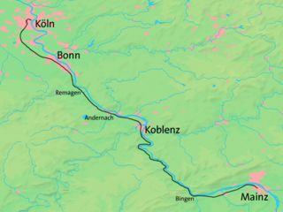
The West Rhine railway is a famously picturesque, double-track electrified railway line running for 185 km from Cologne via Bonn, Koblenz, and Bingen to Mainz. It is situated close to the western (left) bank of the river Rhine and mostly aligned to allow 160 km/h operation between Cologne and Koblenz and between Bingen and Mainz. Line speed between Koblenz and Bingen is restricted by the meandering nature of the Rhine Gorge, a UNESCO World Heritage Site.

The Cologne Ring is a semi-circular, some 6 km long urban boulevard in Innenstadt, Cologne and the city's busiest and most prominent street system. The Cologne Ring is a four lane street and part of Bundesstraße 9.

The Free State of Bottleneck was a short-lived quasi-state that existed from 10 January 1919 until 25 February 1923. It was formed out of part of the Prussian province of Hesse-Nassau as a consequence of the occupation of the Rhineland following World War I. The Bottleneck is now part of the modern German states of Hesse and Rhineland-Palatinate.

Millerstown is an unincorporated community in eastern Johnson Township, Champaign County, Ohio, United States. It lies at the intersection of Heck Hill, Ward, and Zimmerman Roads, 2+1⁄2 miles (4.0 km) north of U.S. Route 36. Nettle Creek, a tributary of the Mad River, flows past Millerstown. It is located approximately 4 miles northeast of the city of St. Paris and 10 miles (16 km) west-northwest of the city of Urbana, the county seat of Champaign County.

Haus Carstanjen is a castle on the River Rhine in Plittersdorf, Bad Godesberg, a district of Bonn, Germany.

Ghassira is a town in Batna Province, north-eastern Algeria.

Cochranville is a census-designated place (CDP) in West Fallowfield Township, Chester County, Pennsylvania, United States. The population was 668 at the 2010 census. It is the hometown of Olympic swimmer Cierra Runge.

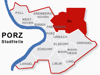
Eil is a suburb of Cologne, Germany located in the city district of Porz, south-east of the city center. With an area totalling 16,24 km2, it is the largest suburb in the city, although not all of the land is built up.

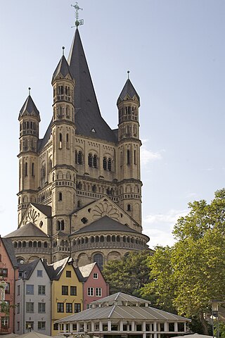
The twelve Romanesque churches of Cologne are twelve landmark churches in the Old town (Altstadt) of Cologne, Germany. All twelve churches are Catholic.

Weißhausstraße is a station on the Cologne Stadtbahn line 18, located in the Cologne district of Lindenthal. The station lies on Luxemburger Straße, at its junction with Universitätsstraße/Weißhausstraße, after the latter of which the station is named. It's close to the University of Cologne, the Justizzentrum and Uni-Center Cologne, and the inner green belt.

Monte Troodelöh is the highest point in the municipal area of the city of Cologne. It lies in the Rath/Heumar district, approximately 1,250 metres south of the A4 at Wolfsweg between the intersection of Pionier-Hütten-Weg and the Brück-Forsbacher Weg.

The Hochsimmer is a volcanic cone, 587.9 m above sea level (NHN), in the Eifel Mountains in Germany. It rises near Ettringen in the Rhineland-Palatine county of Mayen-Koblenz. At the summit is an observation tower, the Hochsimmer Tower.