
This is a list of national primary roads, national secondary roads, regional roads, and officially designated scenic routes in County Mayo in Ireland. [1] [2] [3]
This is a list of national primary roads, national secondary roads, regional roads, and officially designated scenic routes in County Mayo in Ireland. [1] [2] [3]
County Mayo is a county in Ireland. In the West of Ireland, in the province of Connacht, it is named after the village of Mayo, now generally known as Mayo Abbey. Mayo County Council is the local authority. The population was 130,507 at the 2016 census. The boundaries of the county, which was formed in 1585, reflect the Mac William Íochtar lordship at that time.

Connacht, or Connaught, is one of the provinces of Ireland, in the west of Ireland. Until the ninth century it consisted of several independent major Gaelic kingdoms.

Claremorris is a town in County Mayo in the west of Ireland, at the junction of the N17 and the N60 national routes. It is the fastest growing town in the county. There was a 31% increase in the town's population between 2006 and 2011 and a 23% increase between 2002 and 2006. The population of Claremorris in the 2016 Census was 3,687, rising from 3,412 in the 2011 Census.

The N5 road is a national primary road in Ireland, connecting Longford town with Westport. It is the main access route from Dublin to most of County Mayo, including the county's largest towns, Castlebar, Ballina, and Westport.

Louisburgh is a small town on the southwest corner of Clew Bay in County Mayo, Ireland. It is home to Sancta Maria College and the Gráinne O'Malley Interpretive Centre.
Partry is a village and a civil parish formerly called Ballyovey in County Mayo, Ireland. It is located at the junction of the N84 and R330 roads between the towns of Ballinrobe and Castlebar, and between Lough Carra and Lough Mask. The lakes Cloon Lough and Lough Nacorralea are located near Partry.

A regional road in the Republic of Ireland is a class of road not forming a major route, but nevertheless forming a link in the national route network. There are over 11,600 kilometres of regional roads. Regional roads are numbered with three-digit route numbers, prefixed by "R". The equivalent road category in Northern Ireland are B roads.

The N59 road is a national secondary road in Ireland. It commences in County Sligo, south of Sligo Town at the Belladrehid interchange with the N4 north of Ballysadare. The route circles around the west of Ireland, passing west from Sligo into County Mayo and through Ballina. The N59 continues around Mayo, proceeding indirectly to Westport. Continuing south through Mayo into County Galway, the road passes through the village of Leenaun. The 182-year-old bridge in the centre of the village, carrying the road across the River Lahill, collapsed in floods on 18 July 2007. Due to the local terrain and road network, the diversionary route for getting from the south of the village to Westport was 110 km long. A temporary bridge was opened eight days after the floods, on 27 July. It has since been replaced by a new bridge.
A registration district in the United Kingdom is a type of administrative region which exists for the purpose of civil registration of births, marriages, and deaths and civil partnerships. It has also been used as the basis for the collation of census information.
Carra is one of the nine baronies of County Mayo in Ireland, located in the mid-south area of the county. It is sometimes known as Burriscarra. It incorporates the town of Castlebar, the villages of Tourmakeady, Belcarra and Turlough, where the National Museum of Country Life is situated.

The Archdiocese of Tuam is an ecclesiastical territory or archdiocese of the Catholic Church located in western Ireland. The archdiocese is led by the Archbishop of Tuam, who serves as pastor of the mother church, the Cathedral of the Assumption and Metropolitan of the Metropolitan Province of Tuam. According to tradition, the "Diocese of Tuam" was established in the 6th century by St. Jarlath. The ecclesiastical province, roughly co-extensive with the secular province of Connacht, was created in 1152 by the Synod of Kells.

Joyce Country is a cultural region in counties Galway and Mayo in Ireland. It is sometimes called Partry, after the former tribal territory of the Partraige, which it largely matches. Part of it falls within the Connacht Gaeltacht. Joyce Country lies on the shores of Lough Mask and Lough Corrib, and includes the Partry Mountains. It is a rural area that includes small settlements such as Clonbur, Cong, Cornamona and Toormakeady. It borders Connemara, to its south and west.
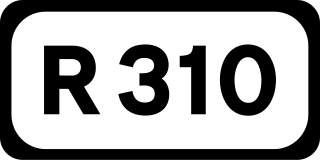
The R310 road is a regional road in County Mayo, Ireland. South to north the route connects the town of Castlebar to Ballina. En route it crosses over a strait linking Lough Conn and Lough Cullin at Pontoon, part of River Moy outflow.

Loch Na Fooey, also Loch Nafooey or Lough Nafooey, is a rectangular shaped glacial lake in County Galway, Ireland. Part of the north-eastern shore lies along the border to County Mayo. The closest village is Finny, County Mayo with the Galway village of Leenaun approximately 11 km distant.
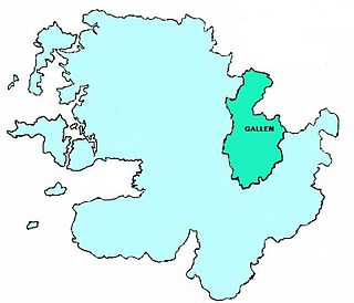
The Barony of Gallen is one of the nine baronies in County Mayo, Ireland. It is situated in the eastern part of the county south of the town of Ballina, bordering County Sligo. It incorporates the area between Foxford, Ballyvary (southwest), Swinford (south) and Bonniconlon (east).

The R300 road is a regional road in southwest County Mayo and north County Galway in Ireland. It connects the R330 road at Cloonee and the nearby N84 road at Partry to the R345 road at Clonbur, 36.2 kilometres (22.5 mi) to the south. It passes through the area known as Joyce Country between the Partry Mountains and Lough Mask.

Ballina is a town in north County Mayo, Ireland. It lies at the mouth of the River Moy near Killala Bay, in the Moy valley and Parish of Kilmoremoy, with the Ox Mountains to the east and the Nephin Beg mountains to the west. The town occupies two baronies; Tirawley on the west bank of the Moy River, and Tireragh, a barony within the County of Sligo, on its east banks. As of 2016, the population of Ballina was 10,171.