
Newtownards is a town in County Down, Northern Ireland. It lies at the most northern tip of Strangford Lough, 10 miles (16 km) east of Belfast, on the Ards Peninsula. It is in the civil parish of Newtownards and the historic baronies of Ards Lower and Castlereagh Lower. Newtownards is in the Ards and North Down Borough. The population was 29,677 in the 2021 Census.

County Down is one of the six counties of Northern Ireland, one of the nine counties of Ulster and one of the traditional thirty-two counties of Ireland. It covers an area of 961 sq mi (2,490 km2) and has a population of 552,261. It borders County Antrim to the north, the Irish Sea to the east, County Armagh to the west, and County Louth across Carlingford Lough to the southwest.
Comber is a town in County Down, Northern Ireland. It lies 5 miles (8 km) south of Newtownards, at the northern end of Strangford Lough. It is situated in the townland of Town Parks, the civil parish of Comber and the historic barony of Castlereagh Lower. Comber is part of the Ards and North Down Borough. It is also known for Comber Whiskey which was last distilled in 1953. A notable native was Thomas Andrews, the designer of the RMS Titanic and was among the many who went down with her. Comber had a population of 9,071 people in the 2011 Census.
Ards was a local government district in Northern Ireland with the status of borough. It was one of twenty-six districts formed on 1 October 1973, and had its headquarters in Newtownards. It was merged with neighbouring North Down on 1 May 2015 to form the new Borough of Ards and North Down. Other towns in the defunct Borough included Portaferry, Comber, and Donaghadee, and the population of the area was 78,078 according to the 2011 census.
The Belfast and County Down Railway (BCDR) was an Irish gauge railway in Ireland linking Belfast with County Down. It was built in the 19th century and absorbed into the Ulster Transport Authority in 1948. All but the line between Belfast and Bangor was closed in the 1950s, although some of it has been restored near Downpatrick by a heritage line, the Downpatrick and County Down Railway.

Ballymacarrett or Ballymacarret is the name of both a townland and electoral ward in Belfast. The townland is in County Down and the electoral ward is part of the Titanic district electoral area of Belfast City Council.

Dundonald is a large settlement and civil parish in County Down, Northern Ireland, United Kingdom. It lies east of Belfast and is often considered a suburb of the city. It is home to the Ulster Hospital, Dundonald International Ice Bowl, Dundonald Omnipark, has a Park and Ride facility for the Glider, access to the Comber Greenway and several housing developments. John de Courcey established a keep including a motte-and-bailey in the 12th century. This is known as Moat Park and can be accessed from Church Green, Comber Road and the Upper Newtownards Road.
The Tonic Cinema was built in 1936 in Bangor, Northern Ireland. At the time it was the largest Cinema in Ireland with 2,001 seats. It was demolished in 1992 following a fire. The old Compton Theatre Organ, formerly in the Tonic Cinema, was in the care of Bangor Academy School but following the demolition of the school, the organ was moved to north east England where it is in the care of an enthusiast in Hull.
The County Down Spectator and Ulster Standard is a weekly tabloid-sized newspaper based in Bangor, County Down, Northern Ireland, UK. It generally serves the area covered by the North Down and Ards council areas. It is published by Spectator Newspapers and comes in three versions, for Bangor, Newtownards and Holywood. From 1955 to 1983, the newspaper was edited by Annie Roycroft, the first woman in Ireland to be the editor.

The A20 is a road in County Down in Northern Ireland. It runs from Belfast to Newtownards and on to Portaferry.

Ballybeen, also known as Ballybeen Housing Estate, is the second-biggest housing estate in Northern Ireland. It is in the village of Dundonald, on the outskirts of east Belfast. It lies within the townlands of Ballybeen and Carrowreagh, between the Newtownards Road and Comber Road. Started in 1963, and mostly completed by 1971, the estate consists of some 2,400 dwellings. Most of the street names are Scottish in origin as the architects who designed the estates layout mostly came from Scotland. It lies within the Borough of Castlereagh and the Belfast East Parliamentary and Assembly constituency. In the 2001 census the area had a population of 9,170.

European route E1 is a series of roads in Europe, part of the United Nations International E-road network, running from Larne, Northern Ireland to Seville, Spain. There is a sea crossing between Rosslare Harbour, in Ireland, and Ferrol, but no ferry service. The road also passes through Portugal – past the city of Porto, through the capital, Lisbon, and then south to the Algarve, passing Faro before reaching the Spanish border west of Huelva.
The Comber Greenway is a 7-mile (11 km) traffic-free section of the National Cycle Network that runs along the old Belfast-Comber railway line. The cycle path starts on Dee Street in east Belfast and finishes at Comber in County Down. As well as a cycling path, it is also popular with people on foot. The most recent addition to the route was in November 2008 when the final link between Old Dundonald Road/Comber Rd junction and Comber was opened. This added 1.6 miles (2.6 km) to the route. One section runs through a SLNCI-designated Wetland ecosystem.
North Down was a constituency of the Parliament of Northern Ireland.

The A22 is a road in County Down, in Northern Ireland. Its route starts in Dundonald and runs to Comber, forming the main transport corridor connecting Belfast and Comber, a commuter town situated 8 miles outside of the city. After bypassing Comber town itself, the route continues along the eastern shores of, though not directly adjacent to, Strangford Lough. The route passes through Lisbane, Balloo, and Killyleagh, terminating in Downpatrick.

Comber railway station was on the Belfast and County Down Railway which ran from Belfast to Newcastle, County Down in Northern Ireland.

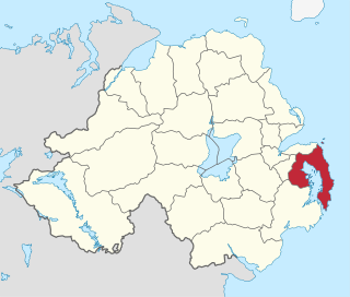
Castlereagh Lower is a historic barony in County Down, Northern Ireland. It was created by 1841 with the division of Castlereagh into two. The barony roughly matches the former Gaelic territory of Uí Blathmaic, anglicized Blathewic. It is bordered by three other baronies: Ards Lower to the east; Dufferin to the south; and Castlereagh Upper to the west and south-west. Castlereagh Lower is also bounded by Belfast Lough to the north and Strangford Lough to the south-east.

Lisbane is a small village and townland in the parish of Tullynakill and the barony of Castlereagh Lower in County Down, Northern Ireland. It is between Balloo and Comber on the A22 road, 5 kilometres south-east of Comber. It is near Strangford Lough in the Ards and North Down Borough Council.


