
Touba Department is a department of Bafing Region in Woroba District, Ivory Coast. In 2014, its population was 75,032 and its seat is the settlement of Touba. The sub-prefectures of the department are Dioman, Foungbesso, Guintéguéla, and Touba.

Kidira is a town and commune in Tambacounda Region of eastern Senegal, lying near the Malian border. Its population in 2013 was about 10,000.

The Falémé River is a river in West Africa. The Falémé arises in northern Guinea and flows in a north-northeast direction to Mali, forming a short portion of the border between Guinea and Senegal. It turns north and then forms a portion of the border between Mali and Senegal, before joining the Sénégal River 50 km upstream of the town of Bakel in Senegal.

The Bafing River runs through Guinea and Mali and is about 760 kilometres (470 mi) long. It joins with the Bakoy River at Bafoulabé to form the Sénégal River in the Kayes Region of western Mali. In Manding languages, Bafing signifies 'black river' and Bakoye 'white river'. The Bafing forms part of the international border between Guinea and Mali.
Nene Washes is a 1,522.1 hectare biological Site of Special Scientific Interest on the bank of the River Nene east of Peterborough in Cambridgeshire. It is also a Ramsar internationally important wetland site, a Special Area of Conservation, a Special Protection Area and a Nature Conservation Review site. An area of 280 hectares is managed by the Royal Society for the Protection of Birds.

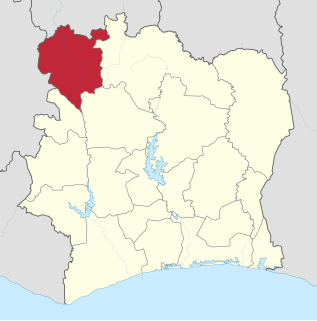
Bafing Region is one of the 31 regions of Ivory Coast and is part of Woroba District. The region's seat is Touba. The region's area is 8,922 km², and its population in the 2014 census was 183,047.
Denguélé Region is a defunct region of Ivory Coast. From 1997 to 2011, it was a first-level subdivision region. The region's capital was Odienné and its area was 20,997 km². Since 2011, the territory formerly encompassed by the region is co-extensive with Denguélé District.

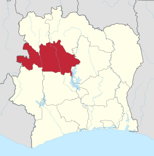
Worodougou Region is one of the 31 regions of Ivory Coast and is currently one of three regions of Woroba District. The region's seat is Séguéla. The region's population in the 2014 census was 662,092.
Slieve Beagh or Sliabh Beagh is a mountainous area straddling the border between County Monaghan in the Republic of Ireland and County Fermanagh and County Tyrone in Northern Ireland. It includes the highest point in County Monaghan. The point where the three counties meet, which is also in the Sliabh Beagh, is referred to as "Three County Hollow".
The wildlife of Mali, composed of its flora and fauna, is widely varying from the Saharan desert zone to the Sahelian east–west zone, to Mali, a landlocked francophone country in North Africa; large swathes of Mali remain unpopulated but has three sub-equal vegetation zones; the country has Sahara Desert in the north, the Niger River Basin at its center and the Senegal River on the south.

Lake Manantali is a large artificial lake, formed by the 1989 construction of the Manantali Dam, on the Bafing River in Mali. Its northern point is located 90 km to the south-east of the city of Bafoulabé.

Kéniéba Cercle is a subdivision of the Kayes Region of Mali. The administrative center (chef-lieu) is the town of Kéniéba.
Merja Zerga or Lagune de Moulay Bou Selham is a tidal lagoon on the Atlantic coast of Morocco, 70 km north of the city of Kenitra. Classified as a Permanent Biological Reserve in 1978, it is managed by several government agencies.

The Lakes Argyle and Kununurra Ramsar Site comprises an extensive system of artificial freshwater reservoirs, with their associated permanent wetlands, formed by damming the Ord River in the eastern part of the Kimberley Region of northern Western Australia. The reservoirs include Lake Argyle and Lake Kununurra. There are numerous endemic plants and a rich fauna. The 1,500 km2 (580 sq mi) site was designated a wetland of international importance under the Ramsar Convention on 7 June 1990, making it Ramsar Site 478.
The South Funen Archipelago is the popular name for the part of the Baltic Sea south of the ports of Faaborg and Svendborg on the Danish island of Funen. The depth of the sea is typically between 20 and 30 meters. The archipelago includes some 55 low-lying Danish islands, including Ærø, Tåsinge, Thurø, Lyø, Strynø and Avernakø.

Koro Department is a department of Bafing Region in Woroba District, Ivory Coast. In 2014, its population was 59,210 and its seat is the settlement of Koro. The sub-prefectures of the department are Booko, Borotou, Koro, Mahandougou, and Niokosso.
Woroba District is one of fourteen administrative districts of Ivory Coast. The district is located in the northeast part of the country. The capital of the district is Séguéla.
The Montreux Record is a register of wetland sites on the List of Ramsar wetlands of international importance where changes in ecological character have occurred, are occurring, or are likely to occur as a result of technological developments, pollution or other human interference. It is a voluntary mechanism to highlight specific wetlands of international importance that are facing immediate challenges. It is maintained as part of the List of Ramsar wetlands of international importance.

