
The Bahamas, known officially as the Commonwealth of The Bahamas, is a country within the Lucayan Archipelago. The archipelagic state consists of more than 700 islands, cays, and islets in the Atlantic Ocean, and is located north of Cuba and Hispaniola, northwest of the Turks and Caicos Islands, southeast of the U.S. state of Florida, and east of the Florida Keys. The capital is Nassau on the island of New Providence. The designation of "the Bahamas" can refer either to the country or to the larger island chain that it shares with the Turks and Caicos Islands. The Royal Bahamas Defence Force describes the Bahamas territory as encompassing 470,000 km2 (180,000 sq mi) of ocean space.

The Bahamas are a group of about 700 islands and cays in the western Atlantic Ocean, of which only between 30 and 40 are inhabited. The largest of the islands is Andros Island, located north of Cuba and 200 kilometres southeast of Florida. The Bimini islands are to its northwest. To the North is the island of Grand Bahama, home to the second-largest city in the country, Freeport. The island of Great Abaco is to its east. In the far south is the island of Great Inagua, the second-largest island in the country. Other notable islands include Eleuthera, Cat Island, San Salvador Island, Acklins, Crooked Island, and Mayaguana. Nassau is the capital and largest city, located on New Providence. The islands have a tropical savannah climate, moderated by the Gulf Stream.
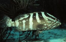
The Nassau grouper is one of the large number of perciform fishes in the family Serranidae commonly referred to as groupers. It is the most important of the groupers for commercial fishery in the West Indies, but has been endangered by overfishing.

Andros Island is an archipelago within the Bahamas, the largest of the Bahamian Islands. Politically considered a single island, Andros in total has an area greater than all the other 700 Bahamian islands combined. The land area of Andros consists of hundreds of small islets and cays connected by mangrove estuaries and tidal swamplands, together with three major islands: North Andros, Mangrove Cay, and South Andros. The three main islands are separated by "bights", estuaries that trifurcate the island, connecting the island's east and west coasts. It is 104 miles (167 km) long by 40 miles (64 km) wide, at the widest point.

A cay, also spelled caye or key, is a small, low-elevation, sandy island on the surface of a coral reef. Cays occur in tropical environments throughout the Pacific, Atlantic and Indian Oceans.

San Salvador Island is an island and district of the Bahamas. It is widely believed that during Christopher Columbus' first expedition to the New World, San Salvador Island was the first land he sighted and visited on 12 October 1492; he named it San Salvador after Christ the Saviour. Columbus' records indicate that the native Lucayan inhabitants of the territory, who called their island Guanahani, were "sweet and gentle".

The Abaco Islands lie in the northern Bahamas 180 miles (290 km) east of South Florida. They comprise the main islands of Great Abaco and Little Abaco, along with smaller barrier cays. The northernmost are Walker's Cay, and its sister island Grand Cay. To the south, the next inhabited islands are Spanish Cay and Green Turtle Cay, with its settlement of New Plymouth, Great Guana Cay, private Scotland Cay, Man-O-War Cay, and Elbow Cay, with its settlement of Hope Town. Southernmost are Tilloo Cay and Lubbers Quarters. Another of note off Abaco's western shore is onetime Gorda Cay, now a Disney Island and cruise ship stop and renamed Castaway Cay. Also in the vicinity is Moore's Island. On the Big Island of Abaco is Marsh Harbour, the Abacos' commercial hub and the Bahamas' third largest city, plus the resort area of Treasure Cay. Both have airports. A few mainland settlements of significance are Coopers Town and Fox Town in the north and Cherokee and Sandy Point in the south. Administratively, the Abaco Islands constitute seven of the 31 Local Government Districts of the Bahamas: Grand Cay, North Abaco, Green Turtle Cay, Central Abaco, South Abaco, Moore's Island, and Hope Town.

Grand Bahama is the northernmost of the islands of The Bahamas, lying 84 kilometres (52 mi) off Palm Beach, Florida. It is the fourth largest island in the Bahamas island chain of approximately 700 islands and 2,400 cays. The island is roughly 530 square miles (1,400 km2) in area and approximately 153 kilometres (95 mi) long west to east and 24 kilometres (15 mi) at its widest point north to south. Administratively, the island consists of the Freeport Bonded Area and the districts of East Grand Bahama and West Grand Bahama.

Freeport is a city, district and free trade zone on the island of Grand Bahama of the northwest Bahamas. In 1955, Wallace Groves, a Virginian financier with lumber interests in Grand Bahama, was granted 50,000 acres (20,234 ha) of pineyard with substantial areas of swamp and scrubland by the Bahamian government with a mandate to economically develop the area. Freeport has grown to become the second most populous city in the Bahamas.

Exuma is a district of the Bahamas, consisting of over 365 islands, also called cays.

Inagua is the southernmost district of the Bahamas, comprising the islands of Great Inagua and Little Inagua. The headquarters for the district council are in Matthew Town.

Rum Cay is an island and district of the Bahamas. It measures 30 square miles (78 km2) in area, it is located at Lat.: N23 42' 30" - Long.: W 74 50' 00". It has many rolling hills that rise to about 120 feet.

A blue hole is a large marine cavern or sinkhole, which is open to the surface and has developed in a bank or island composed of a carbonate bedrock. Blue holes typically contain tidally influenced water of fresh, marine, or mixed chemistry. They extend below sea level for most of their depth and may provide access to submerged cave passages. Well-known examples can be found in South China Sea, Belize, the Bahamas, Guam, Australia, and Egypt.

The Caribbean reef shark is a species of requiem shark, belonging to the family Carcharhinidae. It is found in the tropical waters of the western Atlantic Ocean from Florida to Brazil, and is the most commonly encountered reef shark in the Caribbean Sea. With a robust, streamlined body typical of the requiem sharks, this species is difficult to tell apart from other large members of its family such as the dusky shark and the silky shark. Distinguishing characteristics include dusky-colored fins without prominent markings, a short free rear tip on the second dorsal fin, and tooth shape and number.
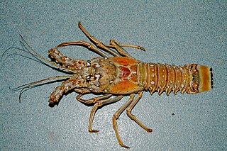
Panulirus argus, the Caribbean spiny lobster, is a species of spiny lobster that lives on reefs and in mangrove swamps in the western Atlantic Ocean.
Emmelichthyops atlanticus, the bonnetmouth, is a marine fish species of grunt native to the western Atlantic Ocean, where it occurs from Florida and the Bahamas to northern South America. This species is the only known member of its genus.

Hogsty Reef is a uninhabited coral atoll located in the southern Bahamas. It is located between Great Inagua and Acklins Island.
The geology of the Bahamas has been researched since the mid-19th century. The islands include eolian sands and limestone built on the basement rock of the Florida-Bahamas Platform. The islands are used to infer sea levels based on the arrangement of reef deposits.

Walker's Cay National Park is a marine national park north of Walker's Cay in North Abaco, the Bahamas. The park was established in 2002, and has an area of 3,840 acres (16 km2). The park's marine environment has a barrier reef, which is used for underwater diving and snorkelling.
The North and South Marine Parks are national parks off the eastern coast of Andros, the Bahamas. The parks were established in 2002 and have an area of 5,000 acres.

