Related Research Articles
Newtown is a part of the Municipality of New-Wes-Valley, located at the North end of Bonavista Bay in the province of Newfoundland and Labrador, Canada. The approximate population is 400. Settlement in Newtown originated around 1850 when people relocated from nearby areas. Newtown is well known for being built on many small islands, and is the home of the Barbour Living Heritage Village.
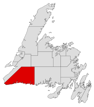
Burgeo-La Poile is a provincial electoral district for the House of Assembly of Newfoundland and Labrador, Canada. As of 2011, there are 7,527 eligible voters living within the district. The district was first created when Newfoundland joined confederation in 1949 as Burgeo and La Poile, and existed until 1975. It was recreated in 1995 following a reduction in the number of seats in the House of Assembly from 52 to 48, forming from the amalgamation of the former districts of La Poile and Burgeo-Bay D'Espoir.
Clarke's Head, Newfoundland is the first community on the north side of the mouth of the Gander River. A small community, which joined with several other small communities, to form Gander Bay.
Ramea is a small village in Newfoundland and Labrador located on Northwest Island, one of a group of five major islands located off the south coast of Newfoundland, Canada. The island is approximately 3.14 km long by 0.93 km wide. The other major islands in the archipelago are Great Island, Middle Island, Harbour Island, and South West Island.

Glovers Harbour, formerly known as Thimble Tickle(s), is an unincorporated community and harbour in the Canadian province of Newfoundland and Labrador. It is located in Notre Dame Bay on the northern coast of the island of Newfoundland. As a local service district, it is led by an elected committee that is responsible for the delivery of certain essential services. It is delineated as a designated place for statistical purposes.
Upper Burgeo is an abandoned settlement in the La Poile District. It was located 3 – 4 km west of Burgeo on Cornelius Island. Burgeo, which still exists today, was then called Lower Burgeo.
Virgin Arm–Carter's Cove is a local service district and designated place on New World Island in the Canadian province of Newfoundland and Labrador. Virgin Arm-Carter's Cove is located approximately 90 km Northwest of Gander in Subdivision H of Division No. 8.
Carmanville is a Canadian community in the province of Newfoundland and Labrador.
Indian Bay is located in Newfoundland, Canada.
Flowers Island was one of the communities in an area on the northeast coast of the Island of Newfoundland called Bonavista North. These communities have a shared history in that they were settled by people from England, predominantly from the West Country—Dorset, Devon Somerset and Hampshire.
Cape Freels is one of the communities that comprise an area on the northeast coast of the Island of Newfoundland, called Bonavista North, in the province of Newfoundland and Labrador, Canada. These communities have a shared history in that they were settled by people from England, predominantly from the West Country - Dorset, Devon, Somerset and Hampshire.
Pool's Island is an incorporated community of Badger's Quay-Valleyfield-Pool's Island in the province of Newfoundland and Labrador, Canada. It is now part of the town of New-Wes-Valley.
Fair Island, also called Vere Island, is a former community on the northeast coast of the island of Newfoundland. Together with other nearby communities it comprises an area called Bonavista North. These communities have a shared history in that they were settled by people from England, predominantly from the West Country - Dorset, Devon Somerset and Hampshire.
Swain's Island, Newfoundland, is actually a group of eight islands on the north side of Bonavista Bay, southeast of Wesleyville. All of these islands once had inhabitants but eventually all of them were resettled, mostly to Wesleyville.
Located on the northwest side of Bonavista Bay, Newfoundland at the mouth of the Indian Bay inlet is a small island named Silver Fox Island that was once inhabited. It is about 3 km in length and about 3 km from Fair Island. The first settling began at Warren's Harbour on the southern side of the island.

English Harbour East is a town in the Canadian province of Newfoundland and Labrador. It is located on the northeast side of Fortune Bay. Settled first by the Mi’kmaq of Newfoundland which used land on the "Neck" of the Harbour, they were joined in the early 1800s, by the English Dodge family and by Irishman Thomas Hynes Sr. European fishermen were first brought to the small community by English merchant family of Newman and Co. based in Harbour Breton, the firm of merchant John Gorman, and the Jersey firm of Nicholle and Co. The town had a population of 117 in the Canada 2021 Census.

Grey River is a local service district and designated place in the Canadian province of Newfoundland and Labrador. Grey River was first settled in the early 1800s by English 'youngsters' brought to Newfoundland via great merchant houses based at Ramea, Burgeo, and Gaultois. James Style(s) was the earliest known resident reported in 1835.
Haystack was a former fishing settlement located on the northern portion of Long Island, Placentia Bay of the island of Newfoundland in the province of Newfoundland and Labrador, Canada. People from the community freely chose to move to other places in the province during the resettlement program of the 1950s and 60s. Unlike most communities, residents were not paid to leave the community.

Division No. 1, Subdivision G is an unorganized subdivision on the Avalon Peninsula in Newfoundland and Labrador, Canada. It is in Division 1 and contains the unincorporated communities of Baccalieu Island, Besom Cove, Bradley's Cove, Burnt Point, Caplin Cove, Daniel's Cove, Grates Cove, Gull Island, Job's Cove, Kingston, Long Beach, Lower Island Cove, Low Point, Northern Bay, Ochre Pit Cove, Red Head Cove, Riverhead, Smooth Cove and Western Bay.
References
- ↑ Lovell's 1871 Provincial Business Directory
- ↑ "Lovell's 1871 Directory - Baker's Tickle".