Lincoln most commonly refers to:
Monroe or Monroes may refer to:
Columbia most often refers to:

Malheur County is one of the 36 counties in the U.S. state of Oregon. As of the 2020 census, the population was 31,571. Its county seat is Vale, and its largest city is Ontario. The county was named after the Malheur River, which runs through the county. The word "malheur" is French for misfortune or tragedy. Malheur County is included in the Ontario, Oregon Micropolitan Statistical Area, which is also included in the Boise Combined Statistical Area. It is included in the eight-county definition of Eastern Oregon.

Baker County is one of the 36 counties in the U.S. state of Oregon. As of the 2020 census, the population was 16,668. The county seat and largest city is Baker City. The county was organized on September 22, 1862, when a portion of Wasco County was partitioned off. The new county's area was reduced in 1864 when Union County was partitioned off, and again in 1887 when Malheur County was partitioned off. The county's lines were last adjusted in 1901 when a parcel was added to the county.

Baker City is a city in and the county seat of Baker County, Oregon, United States. It was named after Edward Dickinson Baker, the only U.S. Senator ever killed in military combat. The population was 10,099 at the time of the 2020 census.
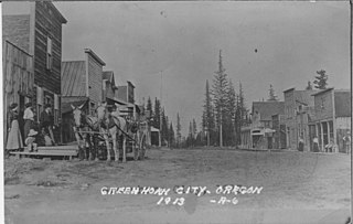
Greenhorn is a nearly non-populated city in Baker and Grant counties in the U.S. state of Oregon. It straddles the Blue Mountain ridge, so that it is located in both Grant County and Baker County. As most of the city is situated in Baker County, and the early residents considered Baker City to be more convenient, for administrative purposes it is considered to be in Baker County.
Rainier may refer to the following:
Crook is another name for criminal.
A baker is someone who primarily bakes bread.
Weatherby is an American gun manufacturer.
Pine Mountain may refer to:

The Wallowa–Whitman National Forest is a United States National Forest in the U.S. states of Oregon and Idaho. Formed upon the merger of the Wallowa and Whitman national forests in 1954, it is located in the northeastern corner of the state, in Wallowa, Baker, Union, Grant, and Umatilla counties in Oregon, and includes small areas in Nez Perce and Idaho counties in Idaho. The forest is named for the Wallowa band of the Nez Perce people, who originally lived in the area, and Marcus and Narcissa Whitman, Presbyterian missionaries who settled just to the north in 1836. Forest headquarters are located in Baker City, Oregon with ranger districts in La Grande, Joseph and Baker City.
Wallowa National Forest was first established as the Wallowa Forest Reserve in Oregon on May 6, 1905 with 747,200 acres (3,024 km2). On March 1, 1907 it was combined with the Chenismus Forest Reserve to create Imnaha National Forest, which was then renamed Wallowa on July 1, 1908. In 1954 it was administratively combined with Whitman National Forest to make Wallowa–Whitman National Forest. The Wallowa National Forest is located overwhelmingly in Wallowa County, Oregon, but there are much smaller portions in Union County, Oregon and Nez Perce and Idaho counties in Idaho. There are local ranger district offices in Enterprise and La Grande, both in Oregon. Forest headquarters are in Baker City, as part of Wallowa-Whitman National Forest. As of 30 September 2008, the Wallowa portion had an area of 997,063 acres (4,034.97 km2), comprising about 44% of the Wallowa-Whitman's acreage.
Baker High School may refer to one of these secondary schools in the United States:
This page is based on this
Wikipedia article Text is available under the
CC BY-SA 4.0 license; additional terms may apply.
Images, videos and audio are available under their respective licenses.