
White County is a county located in the U.S. state of Arkansas. As of the 2010 census, the population was 77,076. The county seat is Searcy. White County is Arkansas's 31st county, formed on October 23, 1835, from portions of Independence, Jackson, and Pulaski counties and named for Hugh Lawson White, a Whig candidate for President of the United States. It is an alcohol prohibition or dry county, though a few private establishments can serve alcohol.

Bald Knob is a city in White County, Arkansas, United States. The population was 2,897 at the 2010 census. Located at the intersection of two of the state's natural regions, Bald Knob is often promoted as "where the Ozarks meet the Delta". Bald Knob is known for its yearly Home Fest held during Mother's Day weekend. It was once known as the leading strawberry producer in the world in the 1950s. Bald Knob was established in 1881.

The Ozarks, also known as the Ozark Mountains, Ozark Highlands or Ozark Plateau, is a physiographic region in the U.S. states of Missouri, Arkansas, Oklahoma and the extreme southeastern corner of Kansas. The Ozarks cover a significant portion of northern Arkansas and most of the southern half of Missouri, extending from Interstate 40 in central Arkansas to Interstate 70 in central Missouri.

The Bald Knob National Wildlife Refuge is a 15,022 acres (60.79 km2) (2014) wildlife refuge located in White County, Arkansas about two miles south of the town of Bald Knob. The refuge is managed by the United States Fish and Wildlife Service. The refuge features large numbers of migratory waterfowl and bald eagles during the winter months.

Big Lake National Wildlife Refuge is an 11,047-acre (45 km²) National Wildlife Refuge located in Mississippi County, Arkansas, managed by the United States Fish and Wildlife Service. It is situated 2 miles (3.2 km) east of Manila, Arkansas, and consists mostly of a shallow lake, swamp, and bottomland hardwood forests. The preservation of habitat for waterfowl in an intensely agricultural region is the primary purpose of the refuge. 6,400 acres (20 km²) of Big Lake is classified as a National Natural Landmark and 2,144 acres (8 km²) are classified as wilderness.

U.S. Route 67 is a major north–south U.S. highway which extends for 1,560 miles (2,511 km) in the Central United States. The southern terminus of the route is at the United States-Mexico border in Presidio, Texas, where it continues south as Mexican Federal Highway 16 upon crossing the Rio Grande. The northern terminus is at U.S. Route 52 in Sabula, Iowa. US 67 crosses the Mississippi River twice along its routing. The first crossing is at West Alton, Missouri, where US 67 uses the Clark Bridge to reach Alton, Illinois. About 240 miles (390 km) to the north, US 67 crosses the river again at the Rock Island Centennial Bridge between Rock Island, Illinois, and Davenport, Iowa. Additionally, the route crosses the Missouri River via the Lewis Bridge a few miles southwest of the Clark Bridge.

The protected areas of the United States are managed by an array of different federal, state, tribal and local level authorities and receive widely varying levels of protection. Some areas are managed as wilderness, while others are operated with acceptable commercial exploitation. As of 2022, the 42,826 protected areas covered 1,235,486 km2 (477,024 sq mi), or 13 percent of the land area of the United States. This is also one-tenth of the protected land area of the world. The U.S. also had a total of 871 National Marine Protected Areas, covering an additional 1,636,523 km2 (631,865 sq mi), or 19 percent of the total marine area of the United States.

The Monongahela National Forest is a national forest located in the Allegheny Mountains of eastern West Virginia, USA. It protects over 921,000 acres of federally managed land within a 1,700,000 acres proclamation boundary that includes much of the Potomac Highlands Region and portions of 10 counties.
The Potomac Highlands of West Virginia centers on five West Virginian counties in the upper Potomac River watershed in the western portion of the state's Eastern Panhandle, bordering Maryland and Virginia. Because of geographical proximity, similar topography and landscapes, and shared culture and history, the Potomac Highlands region also includes Pocahontas, Randolph, and Tucker counties, even though they are in the Monongahela River or New River watersheds and not that of the Potomac River.

Shavers Fork Mountain Complex is the name given to the mountains on either side of Shavers Fork in the highlands portions of Randolph County, Pocahontas County, and Tucker County in West Virginia, USA. Much of the land surrounding the river and its adjacent mountains is protected by Monongahela National Forest including about 20,000 acres (81 km2) of designated wilderness.
Mingo is the name of a Native American tribe and the tribe's language.
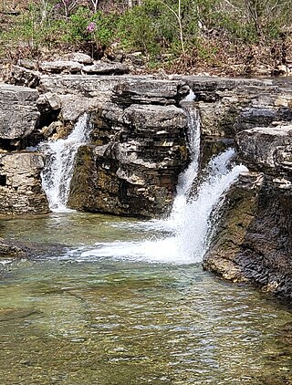
The Hercules Glades Wilderness is a 12,314-acre (50 km2) wilderness area in Taney County in the Ozarks of southwest Missouri. The United States Congress designated it a wilderness in 1976, making it the oldest wilderness area in Missouri. It is one of eight wilderness areas in the Mark Twain National Forest and is within the Ava-Cassville-Willow Springs ranger district, about 10 miles (16 km) northeast of Branson, Missouri. Hercules Glades Wilderness derives its name from the open limestone glades (balds) that dot its landscape. The high points of Coy Bald and Pilot Knob stand 600 feet above Long Creek and offer splendid views of the drainage. Near the middle of the wilderness area is the main set of waterfalls, though Long Creek has several other smaller waterfalls and cascades along its path.

The geography of Arkansas varies widely. The state is covered by mountains, river valleys, forests, lakes, and bayous in addition to the cities of Arkansas. Hot Springs National Park features bubbling springs of hot water, formerly sought across the country for their healing properties. Crowley's Ridge is a geological anomaly rising above the surrounding lowlands of the Mississippi embayment.
Brown House may refer to:
White Grass Ski Touring Center is a cross-country skiing facility located in Canaan Valley in Tucker County, West Virginia. It originally opened in 1979 on White Grass Knob near Harrisonburg, Virginia. Two years later, the operation was moved to the site of the second Weiss Knob Ski Area. The resort uses Weiss Knob's former lodge as its day lodge; it is one of the oldest dedicated cross country ski areas in the United States. Because of its status as a former downhill slope, White Grass is an unusually steep cross country area, with nearly 1,200 feet (370 m) of vertical rise—more than at neighboring downhill slope Canaan Valley Resort State Park. Its 45 trails are rated approximately 30% easy, 55% intermediate, 15% most difficult; climbs are available to the summit of 4,436-foot (1,352 m) Weiss Knob by intermediate skiing, and to 4,308-foot (1,313 m) Bald Knob via easier or intermediate trails. White Grass staff also conduct free natural history snowshoe tours each Sunday into the Canaan Valley Fish and Wildlife Refuge.
Ramsey's Draft Wilderness is a designated wilderness area in the North River Ranger District of the George Washington and Jefferson National Forests of Virginia in the United States. The wilderness area was established in 1984 and comprises 6,518 acres (26.38 km2). It is administered by the US Forest Service.
The Bald Knob Wilderness is a 5,973-acre (24.2 km²) parcel of land listed as a Wilderness Area of the United States. It is, by acreage, the second largest wilderness area located within the U.S. state of Illinois. It is located within the Shawnee National Forest in northwestern Union County, Illinois.

Pilot Knob is located in the Arcadia Valley of Iron County, Missouri, between the towns of Ironton and Pilot Knob. Pilot Knob, so named because of its distinctive shape and prominent position, reaches an elevation of 1,470 feet (450 m) rising 581 feet (177 m) above the Arcadia Valley floor and has a large deposit of iron ore in its upper regions. Pilot Knob is a peak in the St. Francois Mountains.