
Vojvodina, officially the Autonomous Province of Vojvodina, is an autonomous province that occupies the northernmost part of Serbia. It lies within the Pannonian Basin, bordered to the south by the national capital Belgrade and the Sava and Danube Rivers. The administrative center, Novi Sad, is the second-largest city in Serbia.

Banat is a geographical and historical region straddling between Central and Eastern Europe that is currently divided among three countries: the eastern part lies in western Romania ; the western part in northeastern Serbia ; and a small northern part lies within southeastern Hungary.
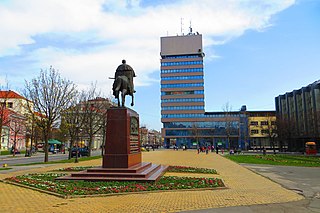
Zrenjanin is a city and the administrative center of the Central Banat District in the autonomous province of Vojvodina, Serbia. The city urban area has a population of 76,511 inhabitants, while the city administrative area has 123,362 inhabitants. The old name for Zrenjanin is Veliki Bečkerek or Nagybecskerek as it was known under Austria-Hungary up until 1918.

Bačka is a geographical and historical area within the Pannonian Plain bordered by the river Danube to the west and south, and by the river Tisza to the east. It is divided between Serbia and Hungary. Most of the area is located within the Vojvodina region in Serbia and Novi Sad, the capital of Vojvodina, lies on the border between Bačka and Syrmia. The smaller northern part of the geographical area is located within Bács-Kiskun County in Hungary.

The North Banat District is one of seven administrative districts of the autonomous province of Vojvodina, Serbia. It lies in the geographical regions of Banat and Bačka. According to the 2011 census, the district has a population of 146,690 inhabitants. The administrative center of the district is the city of Kikinda.

Torontál was an administrative county (comitatus) of the Kingdom of Hungary. Its territory is now divided between Serbia and Romania, except for a small area which is part of Hungary. The capital of the county was Nagybecskerek, the current Zrenjanin.

Mačva is a geographical and historical region in the northwest of Central Serbia, on a fertile plain between the Sava and Drina rivers. The chief town is Šabac. The modern Mačva District of Serbia is named after the region, although the region of Mačva includes only the northern part of this district. A small northern part of Mačva region is in the Autonomous Province of Vojvodina, in the Syrmia District.

Opovo is a town and municipality located in the South Banat District of the autonomous province of Vojvodina, Serbia. The town has a population of 4,546, while Opovo municipality has 10,475 inhabitants.

The Banat of Temeswar or Banat of Temes was a Habsburg province that existed between 1718 and 1778. It was located in the present day region of Banat, which was named after this province. The province was abolished in 1778 and the following year it was incorporated into the Habsburg Kingdom of Hungary.

Kovin is a town and municipality located in the South Banat District of the autonomous province of Vojvodina, Serbia. The town has a population of 13,515, while the municipality has 33,722 inhabitants.
Vojvodina is an autonomous province that comprises northern Serbia. It consists of the southern part of the Pannonian Plain, mostly located north from the Danube and Sava rivers.

The Serbs of Vojvodina are the largest ethnic group in this northern province of Serbia. For centuries, Vojvodina was ruled by several European powers, but Vojvodina Serbs never assimilated into cultures of those countries. Thus, they have consistently been a recognized indigenous ethnic minority with its own culture, language and religion. According to the 2011 census, there were 1,311,776 Serbs in Vojvodina or 67.90% of the population of the province.

Jaša Tomić is a town located in the municipality of Sečanj, in the Central Banat District of Serbia. It is situated in the Autonomous Province of Vojvodina. The town has a Serb ethnic majority and a population numbering 2,982 people.

Srpski Krstur is a village located in Serbia, in the Novi Kneževac municipality of the North Banat District, in the Autonomous Province of Vojvodina. The village has a Serb ethnic majority (69.81%) with a present Romani (13.58%) and Hungarian minority (9.38%). It has a population of 1,620 people.
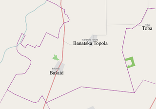
Banatska Topola is a village in the Kikinda municipality, in the North Banat District of the Republic of Serbia. It is situated in the Autonomous Province of Vojvodina. The village has a population of 1,066 of which 570 (53.47%) are ethnic Serbs and 434 (40.71%) are ethnic Hungarians.

The Eparchy of Banat is an ecclesiastical territory or eparchy of the Serbian Orthodox Church in the Banat region, Serbia. It is mostly situated in the autonomous province of Vojvodina, while the eparchy also include a small south-western part of Banat that belongs to the City of Belgrade as well as village of Ostrovo that belongs to the city of Požarevac. The seat of the eparchy is in Vršac.

Klek is a village located in the Zrenjanin municipality, Central Banat District, Vojvodina, Serbia. The village has a Serb ethnic majority (90.80%), and its population is 3,011.

Donji Petrovci is a village in Serbia. It is situated in Ruma municipality, Srem District, Vojvodina province. The village has a Serb ethnic majority and a population of 991 people. There is a significant ancient Roman archaeological site near the village - the remains of large city Bassianae, which in the 3rd century had the highest status of colonia.
Serbia is a southeastern European country.

Dobrinci is a village in Serbia. It is situated in the Ruma municipality, in the Srem District, Vojvodina province. The village has a Serb ethnic majority and its population numbering 1,716 people.