Bangar may refer to one (or more) of the following:
Bangar may refer to one (or more) of the following:

Bandar Seri Begawan (BSB) is the capital and largest city of Brunei. It is officially a municipal area with an area of 100.36 square kilometres (38.75 sq mi) and an estimated population of 100,700 as of 2007. It is part of Brunei–Muara District, the smallest yet most populous district which is home to over 70 per cent of the country's population. It is the country's largest urban centre and nominally the country's only city. The capital is home to Brunei's seat of government, as well as a commercial and cultural centre. It was formerly known as Brunei Town until it was renamed in 1970 in honour of Omar Ali Saifuddien III, the 28th Sultan of Brunei and the father of Sultan Hassanal Bolkiah.
Districts are the principal administrative divisions of Brunei. The country is divided into four districts, namely Brunei-Muara, Belait, Tutong and Temburong. Temburong is an exclave; it is physically separated from the three other districts by the Brunei Bay and Malaysian state of Sarawak. Each district has a town as its administrative and main economic centre, with the exception of Brunei-Muara, where the principal centre is Bandar Seri Begawan, a city and the country's capital.

Temburong District or simply known as Temburong, is the second largest and least populated district in Brunei. It has an area of 1,306 square kilometres (504 sq mi) and the population of 9,444 as of 2021. The district is also home to its administrative centre, Bangar Town, as well as the Temburong River and Ulu Temburong National Park, the country's third longest river and a national park in Brunei respectively.

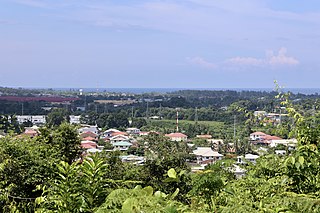
Bangar or officially known as Bandar Town, is a town and administrative centre of Temburong District, Brunei, an isolated territorial exclave separated from the rest of the country by the Malaysian state of Sarawak. The population of the town proper was 451 in 2021. A number of tiny retail establishments may be found throughout the town, providing everything from clothing to handicrafts to basic needs.
The administrative divisions of Brunei Darussalam mainly consist of daerah (districts), mukim (sub-districts), and kampung or kampong (villages). They are organised hierarchically in Brunei Darussalam, with daerah being the largest first level, and kampong the smallest third level.

A mukim is a second-level administrative division of Brunei Darussalam, and the primary sub-division of a larger district. There are thirty-nine mukims within the four districts of the sultanate Brunei Darussalam. A mukim is led by a penghulu, since 2015 elected by democratic vote. A mukim encompasses a number of villages, known in Malay as kampung or kampong. Mukims are administered by the district office of the district where they are located.

Mukim Liang is a mukim in Belait District, Brunei. The population was 14,301 in 2016.

Mukim Amo is a mukim in Temburong District, Brunei. It has an area of 542 square kilometres (209 sq mi); the population was 1,657 in 2021.

Mukim Bangar is a mukim within Temburong District exclave, in Brunei Darussalam. It has a total area of 113 square kilometres ; the population was 2,112 in 2021. The mukim encompasses Bangar, the district's sole town and administrative centre.

Mukim Labu is a mukim in Temburong District, Brunei. It has an area of 292 square kilometres (113 sq mi); the population was 508 in 2021.
Salar may refer to:

Postal codes in Brunei Darussalam are known as postcodes, and they are alphanumeric; consisting of two letters followed by four digits. Postcodes in Brunei are issued by the Postal Services Department, a government department under the Ministry of Communications.
Municipalities in Brunei are settlements which have been incorporated by the government to run as municipalities. They are independent from the hierarchy of the country's subdivisions but nevertheless overlap with mukims and villages, the second- and third-level administrative divisions of Brunei. The governing body of a municipality is municipal department which is a government department under the Ministry of Home Affairs; the head is a chairman which is equivalent to mayor.
The name Kampong Menengah may refer to:
Kampong Amo is a village in Temburong District, Brunei, about 12 kilometres (7.5 mi) from the district town Bangar. It has an area of 5,178 hectares. The population was 394 in 2021; primary ethnic groups include Iban, Murut and Malays.
Kampong Selangan is a village in Temburong District, Brunei, about 9.5 kilometres (5.9 mi) from the district town Bangar. The population was 241 in 2021. It is one of the villages within Mukim Amo. The postcode is PD2751.
Kampong Sibut or simply known as Sibut, is a village in Temburong District, Brunei, about 13 kilometres (8.1 mi) from the district town Bangar. The population was 192 in 2021. It is one of the villages within Mukim Amo. The postcode is PD2151.
Kampong Puni is a village in Temburong District, Brunei, about 3–4 kilometres (1.9–2.5 mi) from the district town Bangar. The population was 259 in 2021. It is one of the villages within Mukim Bangar. The postcode is PA3751.

Kampong Batu Apoi is a village in Temburong District, Brunei, about 5 kilometres (3.1 mi) East from the district town Bangar. The population was 84 in 2021. It is one of the villages within Mukim Batu Apoi. The postcode is PC1151.

Kampong Selapon is a village is Temburong District, Brunei, about 19 kilometres (12 mi) from the district town Bangar. The population was 224 in 2016. It is one of the villages within Mukim Batu Apoi. The postcode is PC3351.