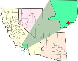
Munisport Landfill is a closed landfill located in North Miami, Florida adjacent to a low-income community, a regional campus of Florida International University, Oleta River State Park, and estuarine Biscayne Bay.

In 1990, the Allied Paper, Inc./Portage Creek/Kalamazoo River in southwestern Michigan was declared by the Environmental Protection Agency (EPA) to be a Superfund site – in other words, an abandoned industrial site containing significant amounts of toxic waste. The EPA and companies responsible for the waste in this area, which includes a three-mile section of Portage Creek as well as part of the Kalamazoo River, into which it flows, are currently involved in an effort to reduce the amount of toxic waste at the site, which is contaminated by PCBs from paper mills and other factories.

The Omega Chemical Corporation was a refrigerant and solvent recycling company that operated from 1976-1991 in Whittier, California. Due to improper waste handling and removal, the soil and groundwater beneath the property became contaminated and the area is now referred to as the Omega Chemical Superfund Site. Cleanup of the site began in 1995 with the removal of hazardous waste receptacles and a multimillion-dollar soil vaporization detoxifying system.

Brown & Bryant Inc. was a chemical distribution company located in Arvin, California in Kern County. The land the company operated on is designated as a U.S. Environmental Protection Agency (EPA) Superfund cleanup site. The company was a formulator of agricultural chemicals including fertilizers, herbicides, insecticides, and fumigants.

The Escambia Wood Treating Company (ETC) site is located at 3910 Palafox Highway, northeast of the intersection of Fairfield Drive in Pensacola, Florida, and is in a mixed industrial, commercial, and residential area (2)(4). The site includes the 26-acre property of the former wood preserving facility and over 60 acres of nearby neighborhoods (1)(4). The facility was in operation from 1942 until 1982, then abandoned by the owner in 1991 (4). During its operation, ETC treated utility poles, foundation pilings, and lumber with creosote and pentachlorophenol (6). Production byproducts were dumped into onsite, unlined containment pits where they seeped into the surrounding soil and groundwater (6).
The Arrowhead Refinery Superfund site is a 10-acre former waste oil recycling facility, located in Hermantown, Minnesota, within a white cedar wetland. The refining process generated a waste stream of highly acidic, metal-laden sludge which was disposed of in an unlined two-acre lagoon on the site and waste process water which was discharged into a wastewater ditch in a wetland area. Arrowhead Refining Company incorporated in 1961 and continued the re-refining activities until 1977. A public health risk assessment stated that if no action was taken to remedy the site, use or development of the site would result in unacceptable health effects on user populations. It was also determined that there was a future potential exposure risk for offsite drinking water wells across the road from the site and in the pathway of the contaminated groundwater plume. The record of decision (ROD) was issued in September 1986.
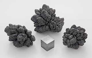
The Atlas Asbestos Mine Superfund Site is located within the Clear Creek Management Area near Fresno County, eighteen miles northwest of Coalinga, California. The mine started operating in 1963, covering 435 acres of a large naturally occurring asbestos deposit. The mine closed in 1979 and was placed in the EPA's National Priorities List (NPL) in 1983 due to the pollution of asbestos in the surrounding soil, air and water creating potential health hazards for local populations and environment.

The Koppers Co., Inc. (KCI) Superfund Site is one of three Superfund sites in Oroville, California, along with Louisiana Pacific Sawmill and Western Pacific Railyard. The KCI Superfund Site is a 200-acre site which served as a wood treatment plant for 50 years. Wood was treated with many chemicals to prevent wood deterioration. The accumulation of these chemicals from spills, fires, and uses has caused this site to be contaminated with the hazardous waste material. Due to soil and groundwater contamination, the site was placed on the National Priorities List in 1984 for remedial action plans to clean up the site to protect surrounding residential areas concerning environmental and human health risks.
The Waste Disposal Inc. Superfund site is an oil-related contaminated site in the highly industrialized city of Santa Fe Springs in Los Angeles County, California. It is approximately 38 acres (15 ha), with St Paul's high school immediately adjacent to the northeast corner of the site. Approximately 15,000 residents of Santa Fe Springs obtain drinking water from wells within three miles (4.8 km) of the site.

The California Gulch site consists of approximately 18 square miles in Lake County, Colorado. The area includes the city of Leadville, parts of the Leadville Historic Mining District and a section of the Arkansas River from the confluence of California Gulch downstream to the confluence of Two-Bit Gulch. The site was listed as a Superfund site in 1983.
Emmell's Septic Landfill (ESL) is located at 128 Zurich Ave, Galloway Township, New Jersey and takes up about 38 acres of space. The landfill was in operation from 1967 until 1979. ESL disposed of liquid and solid waste including many chemicals such as volatile organic compounds (VOCs), Polychlorinated Biphenyls (PCBs), Trichloroethene and Vinyl chloride which all had their own effect on the environment and community. These chemicals affected the groundwater required millions of dollars to reconstruct the groundwater pathways and provide clean water to residents. The landfill holds a Hazardous Ranking Score of a 50/100, qualifying for the Superfund National Priority List. In August 1999, the state acknowledged the site's contamination and held town meetings and provided research upon the site such as groundwater samples. In July 1997, a sitewide investigation was called upon by the United States Environmental Protection Agency. In total the clean up was estimated to cost $5 million to fund this superfund site, and a grant of $3.9 million was given by the Federal Government under the Recovery Act Funding (Previti). Today, the project is still ongoing however, greatly improved since the landfill was discovered.
Bog Creek Farm, located in Howell Township, New Jersey, is a designated Environmental Protection Agency (EPA) Superfund site. Laying on 12 acres of land, Bog Creek Farm is home to several hazardous and life-threatening contamination beginning in 1973 and continuing for a year. Over a decade later, actions began to take place to clean and restore the contaminated soil and water. Bog Creek Farm is situated near several other farms that house horses, growing crops and flowers, and livestock. Less than a mile down the road lies Allaire State Park, a park used by golfers, hunters, and fisherman.
Brook Industrial Park (BIP) is an industrial area occupying 4.5 acres of the Borough of Bound Brook, New Jersey, in the United States of America. It is located on the northern bank of the Raritan River. Industrial, chemical and pesticide operations began in 1971 and eventually lead to the contamination of groundwater and exposure of workers to harmful dioxins. Throughout 1980 to 1988 the United States Environmental Protection Agency (EPA) and the New Jersey Department of Environmental Protection (NJDEP) conducted studies to determine if there were any threats being posed on the workers, community or environment by the BIP companies in their disposal of processed and stored chemicals.
The Chemical Control Corporation superfund site is located at 22 South Front St. Elizabeth, New Jersey. Once a marsh, the 2-acre area next to the Elizabeth River is primarily flat land that is slightly above sea-level. The company, known as the Chemical Control Corporation, worked as a hazardous waste disposal plant from 1972 til it’s condemnation in 1979. Before the April 21, 1980 fire, it was reported that over 50,000 drums of chemicals, ranging from dioxin, benzene, cyanide, toluene, ethylene dichloride and more, were present on the site. State intervention was taken prior to the fire, but it became a matter of national intervention following the fire due to the level of contamination that impacted the environment and community. Cleanup operations have been underway since the early 1980s. The Environmental Protection Agency is considering removing the site from the National Priorities List because of the extensive cleanup that has been done.
The Orange Valley Regional Groundwater Superfund site is a group of wells in Orange and West Orange, two municipalities in Essex County, New Jersey, United States. The groundwater in the public wells are contaminated with the hazardous chemicals of Trichloroethylene (TCE), Dichloroethene (DCE), Tetrachloroethylene (Perchloroethene), 1,1-Dichloroethene (1,1-DCE), and 1,2-Dichloroethene (1,2-DCE). These chemicals pose a huge risk to the towns nearby population, as the wells are a source of public drinking water. In March 2012, the site was added to the National Priorities List (NPL) of the United States Environmental Protection Agency (EPA) Superfund site list.
The Pohatcong Valley Groundwater Contamination superfund site is located in Warren County, Franklin Township, Washington Township, and Washington Borough in New Jersey. It was recognized in the 1970s but not designated into the National Priorities List until 1989. It is a contamination of the Kittany Limestone Aquifer underlying the Pohatcong Valley. This toxic site stretches across 9,800 acres of land. The chemicals that are polluting the groundwater and soil are trichloroethylene (TCE) and perchloroethylene (PCE). If someone were to be exposed to these harmful toxins for a short amount of time it can result in unconsciousness. Long term effects unfortunately include liver and kidney problems. The plans to clean up this superfund site are costing the companies involved, Pechiney Public Packaging Inc., Bristol Meyers Squibb Company, Albea Americas Inc, and Citigroup Inc, about $92 million, and the situation still has not been completely resolved.
The White Chemical Corporation Superfund site is 4.4 acres of contaminated industrial land in downtown Newark, New Jersey, about a half mile away from Newark Airport. The Newark site operated from 1983 to July 1990, selling small amounts of chemicals. Some of the chemicals sold there were Trichloroethylene and 1-2-Dichloroethane. These chemicals were being improperly stored and leaked into the soil and groundwater. The EPA placed the property on the National Priorities List (NPL) in 1991, declaring it a Superfund site.
The Burnt Fly Bog Superfund Site is located in Marlboro Township in Monmouth County, New Jersey. Contamination began around the 1950s and 60's. It was used as a dumping ground for hazardous chemicals and oils. This site was used to reprocess or recycle oil, and it was also used as a landfill during the 1950s. It was used as an intentional and accidental dumping ground for waste and oil. The contamination affected the surface water, deposit and soil contamination. The EPA got involved around the 1980s and addressed the situation. Human Health concerns were a main part of the EPA getting involved because residents that lived only about 1,000 to 2,000 feet around the site. Major components of the remedy included excavation and off-site disposal of contaminated soil from Northerly Wetlands, Tar Patch Area. The back filling of the areas addressed, monitoring of the surface water and sediments, and biological sampling in the Westerly Wetlands. The current status of the site is complete. The remedial stages were completed in the late 90’s and a five-year monitoring of the surface water was completed around 2004.

The G&H Industrial Landfill is a Superfund site located in Shelby Charter Township near Utica, Michigan. The 60-acre (24-hectare) landfill, with about 10 to 20 acres of adjacent property, operated as a waste oil recovery facility from 1955 to 1967. From 1955 to 1974 the site was used as an industrial and municipal landfill. Contaminated soil, surface water, and groundwater with hazardous chemicals have been left behind as a result of the disposal of waste solvents, waste oil and paint sludge. Operation and maintenance activities are ongoing following the cleanup.