AD 71 (LXXI) was a common year starting on Tuesday of the Julian calendar. At the time, it was known as the Year of the Consulship of Vespasian and Nerva. The denomination AD 71 for this year has been used since the early medieval period, when the Anno Domini calendar era became the prevalent method in Europe for naming years.

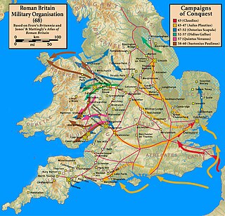
The Roman conquest of Britain was the Roman Empire's conquest of most of the island of Britain, which was inhabited by the Celtic Britons. It began in earnest in AD 43 under Emperor Claudius, and was largely completed in the southern half of Britain by AD 87, when the Stanegate was established. The conquered territory became the Roman province of Britannia. Attempts to conquer northern Britain (Caledonia) in the following centuries were not successful.
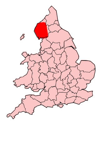
The Carvetii were a Brittonic Celtic tribe living in what is now Cumbria, in North-West England during the Iron Age, and were subsequently identified as a civitas (canton) of Roman Britain.

The Brigantes were Ancient Britons who in pre-Roman times controlled the largest section of what would become Northern England. Their territory, often referred to as Brigantia, was centred in what was later known as Yorkshire. The Greek geographer Ptolemy named the Brigantes as a people in Ireland also, where they could be found around what is now Wexford, Kilkenny and Waterford, while another people named Brigantii is mentioned by Strabo as a sub-tribe of the Vindelici in the region of the Alps.
Scotch Corner is a junction of the A1(M) and A66 trunk roads near Richmond in North Yorkshire, England. It has been described as "the modern gateway to Cumbria, the North East and Scotland", and is a primary destination signed from as far away as the M6 motorway, 50 miles away. The junction's name is derived from the fact that it is the point of divergence for traffic coming from London, the East Midlands and Yorkshire wishing to continue either to Edinburgh and eastern Scotland or to Glasgow and western Scotland.
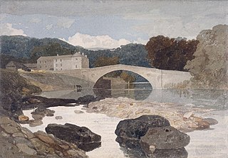
Greta Bridge is a small village on the River Greta in County Durham, England. The bridge is over the River Greta, just south of its confluence with the River Tees. The North Pennines, Teesdale and the Greta Bridge area – including the Meeting of the Waters – became a source of inspiration for romantic artists, poets and writers during the eighteenth century.

Piercebridge is a village and civil parish in the borough of Darlington and the ceremonial county of Durham, England. The population of the civil parish as of the 2011 census was 113. It is situated a few miles west of the town of Darlington. It is on the site of a Roman fort of AD 260–270, which was built at the point where Dere Street crossed the River Tees. Part of the fort is under the village green. The village is sited where the York-Newstead Roman road known as Dere Street crosses the River Tees.

Stanwick St John is a village, civil parish, former manor and ecclesiastical parish in the Richmondshire district of North Yorkshire,, England. It is situated between the towns of Darlington and Richmond, close to Scotch Corner and the remains of the Roman fort and bridge at Piercebridge.

Aldborough is a village 7 miles (11 km) in the civil parish of Boroughbridge, to the north-east of Knaresborough, in North Yorkshire, England.
Stanwick is a village and civil parish in North Northamptonshire, England.

Stanwick Iron Age Fortifications, a huge Iron Age hill fort, sometimes but not always considered an oppidum, comprising over 9 kilometres (5.6 mi) of ditches and ramparts enclosing approximately 300 hectares of land, are situated in Richmondshire, North Yorkshire, England. Whether Stanwick was the stronghold of Venutius or Cartimandua, or perhaps of them both for a brief time before their acrimonious split some time after 51 AD, it is certain that this settlement was one of the most important in Brigantia, the Brigantes kingdom during the early stages of the Roman occupation of Britain. The site is a scheduled monument.

Cliffe is a small village and civil parish in Richmondshire district of North Yorkshire, England. A stream called the Glen runs through the village to the Tees. It is in the Teesdale and Yorkshire Dales national park. It is about 6 miles (10 km) west of Darlington, 10 miles (16 km) north of Richmond and near Piercebridge.

Piercebridge Roman Fort is a scheduled ancient monument situated in the village of Piercebridge on the banks of the River Tees in modern-day County Durham, England. There were Romans here from about AD 70 until at least the early 5th century. There was an associated vicus and bath house at Piercebridge, and another vicus and a villa south of the river at Cliffe. The Victorians used carved stones from this site when they built St Mary's church at Gainford. Part of the site is under Piercebridge village green.
Isurium or Isurium of the Brigantes was a Roman fort and town in the province of Britannia at the site of present-day Aldborough in North Yorkshire, England, in the United Kingdom. Its remains—the Aldborough Roman Site—are in the care of English Heritage.

Vinovia or Vinovium was a Roman fort and settlement situated just over 1 mile (1.6 km) to the north of the town of Bishop Auckland on the banks of the River Wear in County Durham, England. The fort was the site of a hamlet until the late Middle Ages, but the modern-day village of Binchester is about 2 miles (3 km) to the east, near Spennymoor. The ruins are now known as the Binchester Roman Fort.
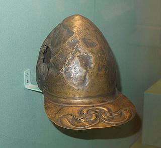
The Meyrick Helmet is an Iron Age bronze peaked helmet, with La Tène style decoration, that is held at the British Museum in London. It is one of only four Iron Age helmets to have been discovered in Britain, the other three being the more famous Waterloo Helmet, the Canterbury Helmet and the North Bersted Warrior helmet. Unlike the Waterloo Helmet, which bears two cone-shaped horns, the Meyrick Helmet is hornless and appears to be based on a Roman model. Vincent Megaw, emeritus professor of archaeology at the University of Leicester, has conjectured that the helmet may have belonged to a British auxiliary fighting in the Roman army during the campaigns against the Brigantes in AD 71–74.
Strutt's Park Roman Fort was a Roman fort in Strutt's Park, a suburb of Derby in Derbyshire, England. It was built around the year 50 and replaced, probably between the years 75 and 80, by a new fort at Little Chester on the opposite bank of the River Derwent.

Brigantia is the land inhabited by the Brigantes, a British Celtic tribe which occupied the largest territory in ancient Britain. The territory of Brigantia which now forms Northern England and part of The Midlands covered the majority of the land between the River Tyne and the Humber estuary forming the largest Brythonic Kingdom in ancient Britain. It was recorded by Ptolemy in the 2nd century AD to extend sea to sea, from the Irish sea on the west coast to the North Sea in the east.
Percival David Turnbull was a British archaeologist.
Edward Wooler was a solicitor, author, councillor, alderman and antiquarian from Darlington.