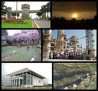
Paulínia is a municipality in the state of São Paulo in Brazil. It is part of the São Paulo Macrometropolis. The population is 100,128 in an area of 138.78 km². The elevation is 590 m. It is known for hosting the Replan, the largest refinery of Petrobras.

Aparecida is a Brazilian municipality in the state of São Paulo. It is located in the fertile valley of the River Paraíba do Sul on the southern (right) bank. It is part of the Metropolitan Region of Vale do Paraíba e Litoral Norte. The population is 36,217 in an area of 121.08 km². The municipality is sometimes referred as Aparecida do Norte.
The Paraíba Valley is a region in the eastern part of the state of São Paulo and the western part of the state of Rio de Janeiro, Brazil. The region is situated along the upper part of the Paraíba do Sul River, roughly between Rio de Janeiro and São Paulo. It has been one of the most important economic regions of Brazil since the start of coffee production in the 19th century. Since the 1950s the region has seen large scale industrialization. The largest cities in the valley are São José dos Campos, Taubaté, Jacareí, Pindamonhangaba, Guaratinguetá and Volta Redonda. The main highway in the valley is the Presidente Dutra Highway (BR-116),

São Paulo/Congonhas AirportPortuguese pronunciation: [kõˈɡõɲɐs] is one of the four commercial airports serving São Paulo, Brazil. The airport is named after the neighborhood where it is located, formerly called Vila Congonhas, property of the descendants of Lucas Antônio Monteiro de Barros (1767–1851), Viscount of Congonhas do Campo, first president of the Province of São Paulo after the independence of Brazil in 1822, during the Empire. In turn, the Viscount's domain was named after the plural of a shrub known in Brazil as congonha-do-campo.
Avianca Brazil, officially Oceanair Linhas Aéreas S/A, is a Brazilian airline based in São Paulo, Brazil. It operates passenger services from 25 destinations. Its main bases are Brasília International Airport and São Paulo-Guarulhos International Airport. According to the National Civil Aviation Agency of Brazil (ANAC), between January and December 2018 Avianca Brazil had 13.4% of the domestic and 7.3% of the international market shares in terms of passengers per kilometer flown, making it the fourth-largest airline both in domestic and international traffic in Brazil.

The Tietê River is a Brazilian river in the state of São Paulo.
Ipiranga is an historical district located in the subprefecture of the same name of São Paulo, Brazil. The name Ipiranga comes from the river of the same name located in the region, which means "red river" in a Tupí–Guaraní language. The Independence Park, where supposedly the Emperor Pedro I of Brazil proclaimed the independence of Brazil, the Paulista Museum, which exhibits classic architecture and a collection of Brazilian colonial artifacts, and the Museum of Zoology of the University of São Paulo, are also located in Ipiranga.

São João da Boa Vista is a municipality in the state of São Paulo in Brazil. The population in 2010 was 83,639 and the area is 516,399 square kilometres (199,383 sq mi). The elevation is 767 metres (2,516 ft).
São Romão is a Brazilian municipality located in the north of the state of Minas Gerais. In 2007 the population was 9,080 in a total area of 2,432 km². It became a municipality in 1943.

Gurinhatã is a municipality in the west of the Brazilian state of Minas Gerais. As of 2007 the population was 6,194 in a total area of 1,844 km². It became a municipality in 1962.
Itapagipe is a municipality in the west of the Brazilian state of Minas Gerais. As of 2007 the population was 14,019 in a total area of 1,795 km². It became a municipality in 1885.

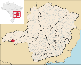
São Francisco de Sales is a municipality in the west of the Brazilian state of Minas Gerais. As of 2007 the population was 5,167 in a total area of 1,129 km². It became a municipality in 1962.

The coastline of Brazil measures 7,491 km, which makes it the 16th longest national coastline of the world. All the coast lies adjacent to geographical features can be found all through the coastal areas, like islands, reefs and bays. The beaches of Brazil are famous in the world and receive a great number of tourists.

Vila Leopoldina is a district in the subprefecture of Lapa in the city of São Paulo, Brazil.
The Pardo River is a river of southern São Paulo state in southeastern Brazil. It is a tributary of the Paranapanema River.
The Turvo River is a river of São Paulo state in southeastern Brazil. It is a tributary of the Grande River, which it joins in the reservoir formed by Água Vermelha Dam.

The Subprefecture of Campo Limpo is one of 32 subprefectures of the city of São Paulo, Brazil. It comprises three districts: Campo Limpo, Capão Redondo, and Vila Andrade. The slum of Paraisópolis, the second largest of the city and surrounded by middle-to-upper class apartment buildings, is located here.


