Related Research Articles

The Skokomish are one of nine tribes of the Twana, a Native American people of western Washington state in the United States. The tribe lives along Hood Canal, a fjord-like inlet on the west side of the Kitsap Peninsula and the Puget Sound basin. Historically the Twana were hunters, fishers, and gatherers who had a nomadic lifestyle during the warmer months, while living in more permanent homes during the winter months.

The Olympic Peninsula is a large arm of land in Western Washington that lies across Puget Sound from Seattle, and contains Olympic National Park. It is bounded on the west by the Pacific Ocean, the north by the Strait of Juan de Fuca, and the east by Hood Canal. Cape Alava, the westernmost point in the contiguous United States, and Cape Flattery, the northwesternmost point, are on the peninsula. Comprising about 3,600 square miles (9,300 km2), the Olympic Peninsula contained many of the last unexplored places in the contiguous United States. It remained largely unmapped until Arthur Dodwell and Theodore Rixon mapped most of its topography and timber resources between 1898 and 1900.
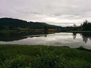
Kamilche is an village in Mason County, Washington, United States. Primarily a farm area, Kamilche is also the home to the Squaxin Indian Tribe. It is at the crossroads of U.S. Route 101 and State Route 108. Kamilche sits at the edge of Little Skookum Inlet, a finger waterway off Puget Sound.
North Beach / Blue Ridge is a neighborhood in the city of Seattle, in the U.S. state of Washington.
Oakland Bay is a tidal estuarial body of water near the city of Shelton, Washington. It is connected to the larger Puget Sound via Hammersley Inlet. The community of Bay Shore, Washington was located on Oakland Bay. The major freshwater inlet is Goldsborough Creek, which runs through the city of Shelton.

Washington's 6th congressional district encompasses the Olympic Peninsula, the Kitsap Peninsula, and most of the city of Tacoma. Its counties include the entirety of Clallam, Kitsap, Mason, Jefferson, and Grays Harbor counties, and part of Pierce County. The 6th district has been represented in the U.S. House of Representatives by Derek Kilmer, a Democrat from Gig Harbor, since January 2013. He succeeded 36-year incumbent and fellow Democrat Norm Dicks, at the time the dean of the Washington delegation.

The Puget Sound Navigation Company (PSNC) was founded by Charles E. Peabody in 1898. Today the company operates an international passenger and vehicle ferry service between Port Angeles, Washington, United States and Victoria, British Columbia, Canada on the MV Coho, through its operating company, Black Ball Ferry Line.

Hammersley Inlet, in southwestern Puget Sound in the U.S. state of Washington, is an arm of water opening north of Arcadia and leading to the city of Shelton and Oakland Bay. Hammersley Inlet is also known as Big Skookum.

The Seattle-Tacoma Shipbuilding Corporation was an American corporation which built escort carriers, destroyers, cargo ships and auxiliaries for the United States Navy and merchant marine during World War II in two yards in Puget Sound, Washington. It was the largest producer of destroyers (45) on the West Coast and the largest producer of escort carriers of various classes (56) of any United States yard active during World War II.

The Puget Sound region is a coastal area of the Pacific Northwest in the U.S. state of Washington, including Puget Sound, the Puget Sound lowlands, and the surrounding region roughly west of the Cascade Range and east of the Olympic Mountains. It is characterized by a complex array of saltwater bays, islands, and peninsulas carved out by prehistoric glaciers.

Winslow Marine Railway and Shipbuilding Company was a shipyard in Puget Sound that operated from 1903 until 1959 on Bainbridge Island, Washington, United States.
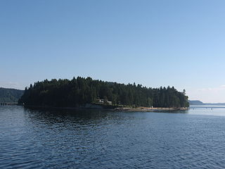
Agate is a small community in the state of Washington, United States. It is located on southern Puget Sound on the north side of the entrance to Hammersley Inlet.
Oyster Bay is an inlet in southern Puget Sound which branches off from Totten Inlet. The bay spans Mason and Thurston counties, in the U.S. state of Washington. Kennedy Creek empties into the bay at the U.S. Highway 101 overpass.
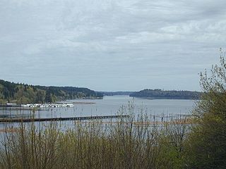
Little Skookum Inlet is a branch of southern Puget Sound which extends westward from Totten Inlet. The community of Kamilche, Washington is on Little Skookum Inlet. It is also the estuary and headwaters for the Little Skookum, Elson, Lynch and Mable Taylor Creeks. The Little Skookum and Totten Inlets flow southwest and form the Kamilche Peninsula, a headland jetting out from Kamilche, Washington.
Ketron Island is an island and a census-designated place (CDP) in Pierce County, Washington, United States. The island had a population of 24 persons according to the 2000 census, and 17 persons at the 2010 census.
The Puget Power Building was a four story tall building in Bellevue, Washington. When it was built in 1956 as the corporate headquarters for Puget Sound Power and Light, it was the tallest building in Bellevue and on the Eastside. It was described by conservationists as "the best example of the International Style on the Eastside".
Snoqualmie Bog Natural Area Preserve in King County, Washington, is part of the Washington Natural Areas Program. It preserves a sphagnum moss bog now rare in the Puget Sound basin, as well as a small strip of old-growth forest.
Mud Bay is the southernmost reach of Puget Sound, at Eld Inlet just outside the city limits of Olympia, Washington. The name Eld Inlet was officially bestowed after a member of the U.S. Navy's Wilkes Expedition, but "Mud Bay" is a local, informal adoption.

Elevation is a cannabis shop on the Squaxin Island Tribe trust lands at Kamilche, Washington, across Washington State Route 108 from the tribe's Little Creek Casino. It became the first tribally operated cannabis shop in the United States in November 2015.

The 2018 Washington wildfire season officially began June 1, 2018. A statewide state of emergency was declared by Governor Jay Inslee on July 31.
References
- Findlay, Jean Cammon, and Paterson, Robin, Mosquito Fleet of South Puget Sound, Arcadia Publishing (2008) ISBN 0-7385-5607-6.
47°14′57″N123°02′42″W / 47.249143°N 123.044931°W
| | This Mason County, Washington state location article is a stub. You can help Wikipedia by expanding it. |