
El Paso County is one of the 64 counties of the U.S. state of Colorado. The 2017 census estimate recorded an approximate population of 699,232 for El Paso County. The Census Bureau's 2017 estimate indicates it is the second-most populous county in Colorado, after the City and County of Denver. The county seat is Colorado Springs, the second most populous city in Colorado.

The American Discovery Trail is a system of recreational trails and roads which collectively form a coast-to-coast hiking and biking trail across the mid-tier of the United States. Horses can also be ridden on most of this trail. It starts on the Delmarva Peninsula on the Atlantic Ocean and ends on the northern California coast on the Pacific Ocean. The trail has northern and southern alternates for part of its distance, passing through Chicago and St Louis respectively. The total length of the trail including both the north and south routes is 6,800 miles (10,900 km). The northern route covers 4,834 miles (7,780 km) with the southern route covering 5,057 miles (8,138 km). It is the only non-motorized coast-to-coast trail.
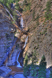
The Broadmoor Seven Falls is a series of seven cascading waterfalls of South Cheyenne Creek in South Cheyenne Cañon, Colorado Springs, Colorado. It is a privately owned tourist attraction since it was opened in the early 1880s. Trails from the top of the falls lead to Midnight Falls, near the headwaters of South Cheyenne Creek, and Inspiration Point. The area sustained a significant flood in September 2013, which had closed Seven Falls until restoration was complete late Summer 2015 by The Broadmoor. The resort bought Seven Falls after it had been owned and operated by families since the 1880s.

Cascade is an unincorporated community and U.S. Post Office in El Paso County, Colorado, United States. The ZIP Code of the Cascade Post Office is 80809.

Before it was founded, the site of modern-day Colorado Springs, Colorado, was part of the American frontier. Old Colorado City, built in 1858 during the Pike's Peak Gold Rush was the Colorado Territory capital. The town of Colorado Springs, was founded by General William Jackson Palmer as a resort town. Old Colorado City was annexed into Colorado Springs. Railroads brought tourists and visitors to the area from other parts of the United States and abroad. The city was noted for junctions for seven railways: Denver and Rio Grande (1870), Denver and New Orleans Manitou Branch (1882), Colorado Midland (1886-1918), Colorado Springs and Interurban, Atchison, Topeka, and Santa Fe (1889), Rock Island (1889), and Colorado Springs and Cripple Creek Railways. It was also known for mining exchanges and brokers for the Cripple Creek Gold Rush.

Colorado Springs geography describes geographical topics regarding the city of Colorado Springs, Colorado in El Paso County, Colorado. With 194.87 sq mi (504.7 km2) of land, it is the state's largest-sized city. Denver is the most populated city.

Palmer Park is a regional park in Colorado Springs, Colorado. Located at 3650 Maizeland Road, the park is several miles northeast of the downtown area. Elevation Outdoors Magazine named it Best Urban Park in its Best of Rockies 2017 list. One of Best of the Springs Expert Picks - Sports & Recreation by The Gazette, Seth Boster states that it may have the city's best views of Pikes Peak and a place "where an escape into deep nature is easy. It is strange and marvelous to look out at urban sprawl while perched on some high rock ledge, surrounded by rugged wilderness."
Pikes Peak Greenway is a 16 mile trail in Colorado Springs, Colorado that parallels Monument and Fountain Creeks and winds through and alongside parks, like Monument Valley Park, and sports complexes. It connects with other trails, such as the Midland Trail, Bear Creek Trail and Templeton Gap Trail.

Memorial Park or Memorial Community Park is a community park in Colorado Springs, Colorado. It has a wide range of sports facilities, including an indoor and outdoor pool, a recreation center, trails and Prospect Lake.

There are a wide range of recreational areas and facilities in Colorado Springs, Colorado.

South Cheyenne Cañon, or South Cheyenne Canyon, is a canyon in Colorado Springs, El Paso County, Colorado. The South Cheyenne Cañon road to Seven Falls is called "The Grandest Mile of Scenery" in Colorado. Seven Falls has been a tourist attraction since it was opened in the early 1880s. Trails from the top of the falls lead to Midnight Falls, near the headwaters of South Cheyenne Creek, and Inspiration Point. The area has been a center for parks, such as the Stratton Park and Colorado College Park. Now, part of South Cheyenne Cañon, including the Starsmore Discovery Center, is in the North Cheyenne Cañon Park. The area sustained a significant flood in September 2013, which has closed Seven Falls until Spring 2015.

Seven Lakes is an abandoned, historical populated place in Teller County, Colorado on the Pikes Peak mountain. It was once the site of the Seven Lakes Hotel along a carriage road to the summit of Pikes Peak. Its waters flow from Beaver Creek to the Lake Moraine reservoir, a supplier of water to Colorado Springs.
St. Peter's Dome is a granite-topped peak on Pikes Peak massif in the Pike National Forest. The peak, at 9,528 feet (2,904 m) in elevation, is located in El Paso County, Colorado, above Colorado Springs. It is located about 8 miles (13 km) from Colorado Springs along Old Stage and Gold Camp Roads. Old Stage Road is picked up behind The Broadmoor and Gold Camp Road winds through Cheyenne Canyon.
The Manitou Park Recreation Area is a recreation area in the Pike National Forest, located 5.2 miles (8.4 km) north of Woodland Park along Colorado State Highway 67 in Teller County, Colorado. The recreation area includes several campgrounds and a picnic area, the Manitou Lake Picnic Area.

Cheyenne Mountain is a triple-peaked mountain in El Paso County, Colorado, southwest of downtown Colorado Springs. The mountain serves as a host for military, communications, recreational, and residential functions. The underground operations center for the North American Aerospace Defense Command (NORAD) was built during the Cold War to monitor North American airspace for missile launches and Soviet military aircraft. Built deep within granite, it was designed to withstand bombing and fallout from a nuclear bomb. Its function broadened with the end of the Cold War, and then many of its functions were transferred to Peterson Air Force Base in 2006.


