Bear Swamp, New Jersey

Last updated

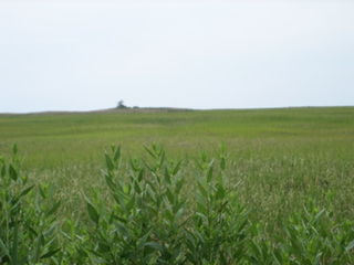
Bear Swamp is a swamp in Cumberland County, southwestern New Jersey, notable for its 215 acres (87 ha) of old-growth forests and the birds they contain. It is divided into two areas, Bear Swamp East and Bear Swamp West, separated from each other by gravel mines and roads.

Swamp A forested wetland

A swamp is a wetland that is forested. Many swamps occur along large rivers where they are critically dependent upon natural water level fluctuations. Other swamps occur on the shores of large lakes. Some swamps have hammocks, or dry-land protrusions, covered by aquatic vegetation, or vegetation that tolerates periodic inundation or soil saturation. The two main types of swamp are "true" or swamp forests and "transitional" or shrub swamps. In the boreal regions of Canada, the word swamp is colloquially used for what is more correctly termed a bog, fen, or muskeg. The water of a swamp may be fresh water, brackish water or seawater. Some of the world's largest swamps are found along major rivers such as the Amazon, the Mississippi, and the Congo.

Cumberland County, New Jersey County in the United States

Cumberland County is a county located in the U.S. state of New Jersey. As of the 2017 Census estimate, the county's population was 152,538, making it the state's 16th-largest county, representing a 2.8% decrease from the 156,898 enumerated at the 2010 United States Census, in turn increasing by 10,460 (+7.1%) from the 146,438 counted in the 2000 Census, retaining its position as the state's 16th-most populous county. Its county seat is Bridgeton. Cumberland County is named for Prince William, Duke of Cumberland. The county was formally created from portions of Salem County as of January 19, 1748.

New Jersey State of the United States of America

New Jersey is a state in the Mid-Atlantic region of the Northeastern United States. It is a peninsula, bordered on the north and east by the state of New York, particularly along the extent of the length of New York City on its western edge; on the east, southeast, and south by the Atlantic Ocean; on the west by the Delaware River and Pennsylvania; and on the southwest by the Delaware Bay and Delaware. New Jersey is the fourth-smallest state by area but the 11th-most populous, with 9 million residents as of 2017, and the most densely populated of the 50 U.S. states; its biggest city is Newark. New Jersey lies completely within the combined statistical areas of New York City and Philadelphia and was the second-wealthiest U.S. state by median household income as of 2017.

Bear Swamp West contains broadleaf swamp forest dominated by black gum, American sweetgum, red maple, and sweetbay magnolia. Other trees present are American beech, swamp white oak, and American holly. Some 100 acres (40 ha) of this forest is old-growth filled with trees of impressive sizes and ages. The black gum are nearly 4 feet (120 cm) in diameter and 600 years old. The sweetgum again nearly 4 feet (120 cm) in diameter, and 300 years old. The red maple are over 4 feet (120 cm) in diameter. The American holly are particularly large, reaching 22 inches (56 cm) in diameter and 80 feet (24 m) tall.

<i>Nyssa sylvatica</i> species of plant

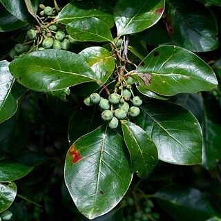
Nyssa sylvatica, commonly known as Tupelo, Black gum, sour gum, is a medium-sized deciduous tree native to eastern North America from the coastal Northeast USA and southern Ontario south to central Florida and eastern Texas, as well as Mexico.

Bear Swamp East is in Belleplain State Forest. It covers 1,439 acres (582 ha) and contains 115 acres (47 ha) of old-growth forest. It has forests similar to Bear Swamp West, but with large Tulip Poplar on hummocks, some reaching 5 feet (150 cm) in diameter and 400 years of age.

Belleplain State Forest

Belleplain State Forest is a 21,320-acre (86.3 km2) New Jersey State Forest in northern Cape May County and eastern Cumberland County. It has many young pine, oak and Atlantic white cedar trees, having better soil than the northern Pine Barrens. It was established in 1928 and the Civilian Conservation Corps (CCC) set up camps here in 1933, converted Meisle Cranberry Bog into Lake Nummy and constructing the original forest headquarters, maintenance building, a road system, bridges, and dams.

A hummock is a small knoll or mound above ground. They are typically less than 15 meters in height and tend to appear in groups or fields. It is difficult to make generalizations about hummocks because of the diversity in their morphology and sedimentology. An extremely irregular surface may be called hummocky.

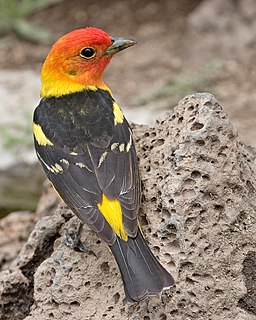
As many as 30 bald eagles nest in the swamp, and it is home to the oldest continuously occupied bald eagle nest in New Jersey. It is a breeding site for red-shouldered hawks, barred owls, and Cooper's hawks, all species of concern in the state. It is one of just two known breeding sites in southern New Jersey for pileated woodpeckers.

Bald eagle A bird of prey from North America

The bald eagle is a bird of prey found in North America. A sea eagle, it has two known subspecies and forms a species pair with the white-tailed eagle. Its range includes most of Canada and Alaska, all of the contiguous United States, and northern Mexico. It is found near large bodies of open water with an abundant food supply and old-growth trees for nesting.

Red-shouldered hawk species of bird

The red-shouldered hawk is a medium-sized hawk. Its breeding range spans eastern North America and along the coast of California and northern to northeastern-central Mexico. Red-shouldered hawks are permanent residents throughout most of their range, though northern birds do migrate, mostly to central Mexico. The main conservation threat to the widespread species is deforestation.

Barred owl large typical owl

The barred owl, also known as northern barred owl or hoot owl, is a true owl native to eastern North America. Adults are large, and are brown to grey with barring on the chest. Barred owls have expanded their range to the west coast of the United States and Canada, where they are considered invasive. Mature forests are their preferred habitat, but they are also found in open woodland areas. Their diet consists mainly of small mammals, but they are also known to prey upon other small animals such as birds, reptiles, and amphibians.

See also

Related Research Articles

Eastern towhee species of bird

The eastern towhee is a large New World sparrow. The taxonomy of the towhees has been under debate in recent decades, and formerly this bird and the spotted towhee were considered a single species, the rufous-sided towhee.

Western tanager species of bird

The western tanager, is a medium-sized American songbird. Formerly placed in the tanager family (Thraupidae), it and other members of its genus are now classified in the cardinal family (Cardinalidae). The species's plumage and vocalizations are similar to other members of the cardinal family.

<i>Liquidambar styraciflua</i> tree species

American sweetgum, also known as American storax, hazel pine, bilsted, redgum, satin-walnut, star-leaved gum, alligatorwood, or simply sweetgum, is a deciduous tree in the genus Liquidambar native to warm temperate areas of eastern North America and tropical montane regions of Mexico and Central America. Sweet gum is one of the main valuable forest trees in the southeastern United States, and is a popular ornamental tree in temperate climates. It is recognizable by the combination of its five-pointed star-shaped leaves and its hard, spiked fruits. It is currently classified in the plant family Altingiaceae, but was formerly considered a member of the Hamamelidaceae.

Marbled murrelet species of bird

The marbled murrelet is a small seabird from the North Pacific. It is a member of the auk family. It nests in old-growth forests or on the ground at higher latitudes where trees cannot grow. Its habit of nesting in trees was suspected but not documented until a tree-climber found a chick in 1974, making it one of the last North American bird species to have its nest described. The marbled murrelet has declined in number since humans began logging its nest trees in the latter half of the 19th century. The decline of the marbled murrelet and its association with old-growth forests, at least in the southern part of its range, have made it a flagship species in the forest preservation movement. In Canada and Alaska, the declines are not so obvious because populations are much larger and the survey techniques have not had sufficient power to detect changes.

<i>Taxodium distichum</i> species of plant

Taxodium distichum is a deciduous conifer in the family Cupressaceae. It is native to the southeastern United States. Hardy and tough, this tree adapts to a wide range of soil types, whether wet, dry, or swampy. It is noted for the russet-red fall color of its lacy needles.

Atlantic coastal pine barrens

The Atlantic coastal pine barrens is a temperate coniferous forest ecoregion of the Northeast United States distinguished by its nutrient-poor, often acidic soils and a pine tree distribution naturally controlled by frequent fires.

Drift Creek Wilderness

Drift Creek Wilderness is a 5,798-acre (2,346 ha) wilderness area in the Siuslaw National Forest on the Oregon Coast. It was created in 1984, along with two other small wilderness areas in the forest - Cummins Creek Wilderness and Rock Creek Wilderness. The elevation of Drift Creek ranges from 150 to 1,500 feet, and is characterized by long steep slopes with broken and uneven terrain. Drift Creek was named for the accumulations of driftwood on its banks.

Rothrock State Forest

Rothrock State Forest is a Pennsylvania state forest in Pennsylvania Bureau of Forestry District #5. The main offices are located in Huntingdon in Huntingdon County, Pennsylvania in the United States.

Beall Woods State Park

Beall Woods State Park is an Illinois state park on 635 acres (257 ha) bordering the Wabash River and Keensburg in Wabash County, Illinois in the United States. 329 acres (133 ha) of the state park is an old-growth forest designated as a Natural Area by the state of Illinois. The trees within the forest consist overwhelmingly of hardwoods of the former Eastern Woodlands ecosystem. Portions of Beall Woods State Park have been designated a National Natural Landmark as the Forest of the Wabash. The state park was created in 1966. The nearest towns with any sizable commercial infrastructure, including hotels and grocery stores, are Grayville and Mount Carmel. The park does host a small primitive campground and maintains a visitor center which opened in April 2001. The park maintains 6 14 miles (10.1 km) of hiking trails, primarily through the Forest of the Wabash portion of the park.

Mohawk Trail State Forest

Mohawk Trail State Forest is a publicly owned forest with recreational features located in the towns of Charlemont, Hawley, and Savoy, Massachusetts. The state forest covers more than 7,700 acres (3,100 ha) of mountain ridges, gorges, and old-growth forests at elevations ranging from around 600 to 2,080 feet. It is managed by the Department of Conservation and Recreation.

Francis Beidler Forest

The Francis Beidler Forest is an Audubon wildlife sanctuary in Four Holes Swamp, a blackwater creek system in South Carolina, United States. It consists of over 16,000 acres (65 km²) of mainly bald cypress and tupelo gum hardwood forest and swamp with approximately 1,800 acres (7 km2) of old-growth forest. It is the largest virgin stand of these trees in the world, with some trees over 1,000 years old. It is a favorite haunt of birdwatchers and is used for biological research projects by area schools.

The Glades (New Jersey)

The Glades is a name for 7,113 acres (28.79 km2) in Newport, New Jersey along the Delaware Bay. Owned by Natural Lands Trust, the formal name of this preserve is the Glades Wildlife Refuge and is publicly accessible at several points. Several of these points are part of New Jersey's Coastal Heritage Route.

<i>Liquidambar orientalis</i> species of plant

Liquidambar orientalis, commonly known as oriental sweetgum or Turkish sweetgum, is a deciduous tree in the genus Liquidambar, native to the eastern Mediterranean region, that occurs as pure stands mainly in the floodplains of southwestern Turkey and on the Greek island of Rhodes.

Pigeon Swamp State Park

Pigeon Swamp State Park is a 1,078-acre (4.36 km2) New Jersey state park located on Deans Rhode Hall Road in South Brunswick, in Middlesex County, New Jersey, United States. It is an undeveloped park, with a mix of habitats including open ponds and uplands hardwood forests. It also includes a good example of an inner coastal plain lowland deciduous hardwood forest. At one time, it was a major nesting site for passenger pigeons before they became extinct. It was declared a National Natural Landmark in December 1976.

Johnson Run Natural Area

Johnson Run Natural Area is a 216-acre (87 ha) nature preserve located in Cameron County, Pennsylvania. The topography consists of a rugged, bouldered plateau dissected by steep-sided streams and covered with somewhere from 26 acres (11 ha) to 50 acres (20 ha) of old-growth forest containing Eastern Hemlock and Eastern White Pine. Some of the white pines are nearly 4 feet (120 cm) in diameter at breast height.

Saddler's Woods is a 25 acres (10 ha) forest in Haddon Township, Camden County, New Jersey that includes the headwater spring of Newton Creek. Despite its location just 5 miles (8.0 km) from Philadelphia, Saddler's Woods includes wetlands, young woodlands, and old-growth forest.

Manahawkin Wildlife Management Area

Manahawkin Wildlife Management Area is a 1,642-acre (664 ha) wildlife management area near Manahawkin, Stafford Township, Ocean County, New Jersey. It was designated a National Natural Landmark in January 1976. It is known for its mature bottomland hardwood forest which contains examples of American sweetgum, red maple and black gum trees.

Phinizy Swamp Nature Park

Phinizy Swamp Nature Park is a 1,100-acre (450 ha) nature park in Augusta, Georgia. The park contains wetlands and woodlands and has a campus for water research and environmental education, which includes a visitor center. It has many bald cypresses draped in Spanish moss and forests of loblolly and longleaf pine trees. Birds commonly found at Phinizy Swamp include: red-shouldered hawks, great blue herons, sora, wood ducks and bald eagles. Sometimes the park yields rarities for Georgia, including black-bellied whistling ducks, and a cave swallow, in 2004. Other wildlife commonly found in the park include frogs and toads; snakes, including water moccasin, pigmy rattlesnake, and copperhead; beavers and muskrat; turtles; and dragonflies. Fishing and hunting are not permitted within the park. Phinizy Swamp Nature Park is managed by Phinizy Center for Water Sciences.

Willard Pond American lake

Willard Pond is a small, protected lake in Antrim, New Hampshire, United States. The lake, located in southwestern New Hampshire, is about 108 acres (44 ha) in size with an average depth of 25 feet (7.6 m) and a maximum depth of 58 feet (18 m). No petroleum motors are allowed, and fly fishing is the only form of fishing allowed. It is part of the dePierrefeu Wildlife Sanctuary, which is owned by the New Hampshire Audubon Society. Because the pond and the land around it are part of the sanctuary, the shore is unable to be developed. Therefore, there are no buildings around the pond and there won't be in the foreseeable future. Willard is instead surrounded by extensive amounts of wilderness and hiking trails that lead around the pond and to the summits of Bald Mountain and Goodhue Hill. Willard is a popular fishing, boating, hiking and swimming destination, and it has become more popular with its mention in numerous magazines and newspapers.

References

Coordinates: 39°16′44″N75°04′41″W / 39.279°N 75.078°W / 39.279; -75.078

Geographic coordinate system Coordinate system

A geographic coordinate system is a coordinate system that enables every location on Earth to be specified by a set of numbers, letters or symbols. The coordinates are often chosen such that one of the numbers represents a vertical position and two or three of the numbers represent a horizontal position; alternatively, a geographic position may be expressed in a combined three-dimensional Cartesian vector. A common choice of coordinates is latitude, longitude and elevation. To specify a location on a plane requires a map projection.