
Brackish water, sometimes termed brack water, is water occurring in a natural environment that has more salinity than freshwater, but not as much as seawater. It may result from mixing seawater and fresh water together, as in estuaries, or it may occur in brackish fossil aquifers. The word comes from the Middle Dutch root brak. Certain human activities can produce brackish water, in particular civil engineering projects such as dikes and the flooding of coastal marshland to produce brackish water pools for freshwater prawn farming. Brackish water is also the primary waste product of the salinity gradient power process. Because brackish water is hostile to the growth of most terrestrial plant species, without appropriate management it is damaging to the environment.

The Ogallala Aquifer is a shallow water table aquifer surrounded by sand, silt, clay, and gravel located beneath the Great Plains in the United States. As one of the world's largest aquifers, it underlies an area of approximately 174,000 sq mi (450,000 km2) in portions of eight states. It was named in 1898 by geologist N. H. Darton from its type locality near the town of Ogallala, Nebraska. The aquifer is part of the High Plains Aquifer System, and resides in the Ogallala Formation, which is the principal geologic unit underlying 80% of the High Plains.

The Colorado River is an approximately 862-mile-long (1,387 km) river in the U.S. state of Texas. It is the 11th longest river in the United States and the longest river with both its source and its mouth within Texas.

The Red River, or sometimes the Red River of the South to differentiate it from the Red River in the north of the continent, is a major river in the Southern United States. It was named for its reddish water color from passing through red-bed country in its watershed. It is known as the Red River of the South to distinguish it from the Red River of the North, which flows between Minnesota and North Dakota into the Canadian province of Manitoba. Although once a tributary of the Mississippi River, the Red River is now a tributary of the Atchafalaya River, a distributary of the Mississippi that flows separately into the Gulf of Mexico. This confluence is connected to the Mississippi River by the Old River Control Structure.

The Brazos River, called the Río de los Brazos de Dios by early Spanish explorers, is the 14th-longest river in the United States at 1,280 miles (2,060 km) from its headwater source at the head of Blackwater Draw, Roosevelt County, New Mexico to its mouth at the Gulf of Mexico with a 45,000-square-mile (116,000 km2) drainage basin. Being one of Texas' largest rivers, it is sometimes used to mark the boundary between East Texas and West Texas.

The Trinity River is a 710-mile (1,140 km) river, the longest with a watershed entirely within the U.S. state of Texas. It rises in extreme northern Texas, a few miles south of the Red River. The headwaters are separated by the high bluffs on the southern side of the Red River.
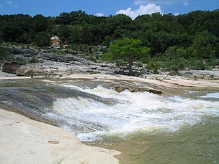
The Pedernales River is a tributary of the Colorado River, approximately 106 miles (171 km) long, in Central Texas in the United States. It drains an area of the Edwards Plateau, flowing west to east across the Texas Hill Country west of Austin. The name "Pedernales", first used in the middle 18th century, comes from a Spanish word for the flint rocks characteristic of the riverbed.
Lake Houston is a reservoir on the San Jacinto River, 15 miles (24 km) northeast of downtown Houston, Texas, United States. The reservoir is the primary municipal water supply for the city of Houston.
Lake Livingston is a reservoir located in Piney Woods in Houston, Madison, Polk, San Jacinto, Trinity and Walker counties in east Texas, United States. Lake Livingston was built and is owned and operated by the Trinity River Authority (TRA) of Texas under contract with the City of Houston for water-supply purposes. The USCG Auxiliary Flotilla 6-9 is also stationed on the lake. The lake is the third-largest lake located in the state of Texas. The Livingston Dam, constructed across the Trinity River about 7 miles (11 km) southwest of the city of Livingston is 2.5 miles (4 km) in length and has an average depth of 55 feet (17 m).
Arroyo Colorado is a river in Hidalgo, Cameron and Willacy Counties, Texas, that flows mostly eastward some 89 miles (143 km) from Lake Llano Grande into the Laguna Madre.
The Atascosa River is a river tributary of the Frio River, which is a tributary of the Nueces River in Texas.
The Attoyac Bayou is a river in eastern Texas. As to the naming, the locals, historical records, and the state of Texas use the phrase 'bayou' but, since 1984, the USGS uses the term 'river'. It flows through Nacogdoches, San Augustine, Shelby and Rusk counties of east Texas. It is a tributary to the Angelina River which it enters within the Sam Rayburn Reservoir.
Coldwater Creek is an intermittently-flowing stream in northeastern New Mexico, and the panhandles of Oklahoma and Texas. As far back as 1907, the USGS reported that Coldwater Creek is a dry sand bed most of the year. One source says that Coldwater Creek is also known as Rabbit Ears Creek, because it rises near Rabbit Ears, a pair of mountain peaks in Union County, New Mexico. According to the United States Geological Survey (USGS), Coldwater Creek drains an area of 1,903 square miles (4,930 km2).

Cross Bayou is a 38.0-mile-long (61.2 km) river in Texas and Louisiana. It is a tributary of the Red River, part of the Mississippi River watershed.
The Little Wichita River is a river in Texas.
Nolan River is a river in north central Texas, running through Johnson County and Hill County and is part of the Brazos River drainage basin. The Nolan's headwaters are in farm land in northwest Johnson County. The river runs generally parallel to, and about 10 miles (16 km) east of, the Brazos River. The Nolan flows in a southeasterly direction from its headwaters for about 27 miles (43 km) to its confluence with the Brazos River in the headwaters of Lake Whitney in Hill County, south of the town of Blum, Texas.

Pine Island Bayou is a tributary of the Neches River located in southeast Texas. It runs about 55 miles from the northwest corner of Hardin County, Texas and flows in a southeastern direction through western Hardin County, turning east and defining the southern Hardin and Jefferson County boundary for about 20 miles until its confluence with the Neches River. Two significant tributaries of Pine Island Bayou are Mayhaw Creek and Little Pine Island Bayou. The lower ten miles of Pine Island Bayou and much of Little Pine Island Bayou are protected from development in the Big Thicket National Preserve. Excluding the last few miles north of Beaumont, the area is not densely populated, and some small towns include Sour Lake and Saratoga, the latter the birthplace of country singer George Jones.

Clear Creek is a small river in Southeast Texas in the United States, which channels much of the run-off in southeast Harris County into Clear Lake and Galveston Bay. Much of the length of the stream forms the boundary between Harris County and Galveston County and all of the boundary with Brazoria County. It originates in the Blue Ridge Oilfield in Fort Bend County.