
AD 66 (LXVI) was a common year starting on Wednesday of the Julian calendar. At the time, it was known as the Year of the Consulship of Telesinus and Paullinus. The denomination AD 66 for this year has been used since the early medieval period, when the Anno Domini calendar era became the prevalent method in Europe for naming years.
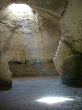
Rock-cut tombs were a form of burial and interment chamber used in ancient Israel. Cut into the landscapes surrounding ancient Judean cities, their design ranges from single chambered, with simple square or rectangular layouts, to multi-chambered with more complex designs. Almost all burial chambers contain a platform for primary burial and an ossuary or other receptacle for secondary burial. There is debate on if these tombs were originally intended for secondary burials, or if that practice arose later.

Kiryat Tiv'on is a town in the Haifa District of Israel, in the hills between the Zvulun (Zebulon) and Jezreel valleys. Kiryat Tiv'on is situated 15 kilometres (9.3 mi) southeast of Haifa, on the main road to Nazareth. Kiryat Tiv'on is the result of the municipal merger of several older settlements, Tiv'on, Elro'i, Kiryat Haroshet and Kiryat Amal. On the outskirts of Tiv'on is a Bedouin township called Basmat Tab'un. In 2022 it had a population of 19,130.

Usha was a city in the Western part of Galilee. The Arab village of Hawsha later occupied the ruins of the old site. The modern kibbutz of Usha, Israel is located nearby to the ruins.
Rabbi Yochanan ben Nuri was a tanna of the 1st and 2nd centuries.

Alexander Zaïd was one of the founders of the Jewish defense organizations Bar Giora and Hashomer, and a prominent figure of the Second Aliyah.

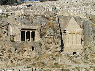
Beit She'arim necropolis is an extensive necropolis of rock-cut tombs near the remains of the ancient Jewish town of Beit She'arim. In early modern times the site was the Palestinian village of Sheikh Bureik; it was depopulated in the 1920s as a result of the Sursock Purchases, and identified as Beit She'arim in 1936 by historical geographer Samuel Klein.
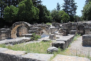
Beit She'arim or Besara was a Roman-era Jewish village from the 1st century BCE until the 3rd century CE which, at one time, was the seat of the Sanhedrin. The village was later known as Sheikh Bureik, and was depopulated in the early 1920s as a result of the Sursock Purchase.
Beit Guvrin may refer to a succession of settlements and their archaeological remains, in proper chronology: Maresha, Beit Guvrin, Eleutheropolis, Bethgibelin, Bayt Jibrin, Kibbutz Beit Guvrin and Beit Guvrin National Park.

Beit She'arim is a moshav in northern Israel. Located in the Galilee near Ramat Yishai, it falls under the jurisdiction of Jezreel Valley Regional Council. As of 2021 it had a population of 813.

Sha'ar HaAmakim is a kibbutz in northern Israel associated with the Hashomer Hatzair movement founded in 1935. Located near Kiryat Tiv'on, it falls under the jurisdiction of Zevulun Regional Council. In 2021 it had a population of 769.
Beit Guvrin-Maresha National Park is a national park in central Israel, containing a large network of caves recognized by UNESCO as a World Heritage Site. The national park includes the remains of the historical towns of Maresha, one of the important towns of Judah during the First Temple Period, and Bayt Jibrin, a depopulated Palestinian town known as Eleutheropolis in the Roman era. However, Maresha and Bayt Jibrin are not part of the UNESCO site, which covers only the cave network.

Jaba', also known as Gaba, or Geba, in historical writings, was a Palestinian Arab village in the Haifa Subdistrict. It was depopulated during the 1948 Arab-Israeli War on July 24, 1948, as part of Operation Shoter. It was located 18.5 km south of Haifa, near Carmel, and ca. 3.25 kilometers (2.02 mi) east of the Mediterranean Sea.

Sheikh Bureik, locally called Sheikh Abreik or Sheikh Ibreik in recent times, was a Palestinian Arab village located 10 miles (16 km) southeast of Haifa. Situated at an ancient site that shows evidence of habitation as early as the Iron Age, it was known as Beit She'arayim in the Roman and Byzantine periods and became an important center of Jewish learning in the 2nd century, with habitation continuing during the Early Islamic period and limited signs of activity from the Crusader period.

Beit Ya'akov is a small neighborhood in Jerusalem, founded in 1877, the ninth Jewish neighborhood outside the walls of the Old City. The neighborhood borders Jaffa Road and Avishar Road. The Mahane Yehuda Market is located there today.

The Vigna Randanini are Jewish Catacombs between the second and third miles of the Appian Way close to the Christian catacombs of Saint Sebastian, with which they were originally confused. The catacombs date between the 2nd and 5th-centuries CE, and take their name from the owners of the land when they were first formally discovered and from the fact that the land was used as a vineyard (vigna). While Vigna Randanini are just one of the two Jewish catacombs in Rome open to the public, they can only be visited by appointment. They are situated below a restaurant and a private villa and entrance is from the Via Appia Pignatelli side. These catacombs were discovered by accident in 1859, although there is evidence that they had been pillaged before then. They cover an area of 18,000 square metres and the tunnels are around 700 metres long, of which around 400 can be seen.
Asra Kadisha is an international organization for the preservation of Jewish cemeteries and gravesites.
Simeon ben Judah ha-Nasi also called Rabban b'Rabbi was a 3rd-century Tanna in the Land of Israel and the younger son of Judah ha-Nasi, who appointed Simeon as hakham of his yeshivah in Beit She'arim.

Ma'ayan Harod National Park is a public park in Israel administered by the Israel Nature and Parks Authority that contains the spring known as Ma'ayan Harod or Ain Jalut that now feeds a recreational swimming pool, as well as the house and tomb of Yehoshua Hankin.