Related Research Articles

The Indian Territory and the Indian Territories are terms that generally described an evolving land area set aside by the United States government for the relocation of Native Americans who held original Indian title to their land as a sovereign independent state. The tribes ceded land they occupied in exchange for land grants in 1803. The concept of an Indian Territory was an outcome of the U.S. federal government's 18th- and 19th-century policy of Indian removal. After the American Civil War (1861–1865), the policy of the U.S. government was one of assimilation.

Niles Charter Township is a charter township of Berrien County in the U.S. state of Michigan. The population was 14,164 at the 2010 census.
Homer Township is a civil township of Calhoun County in the U.S. state of Michigan. It is part of the Battle Creek, Michigan Metropolitan Statistical Area. The population was 3,015 at the 2010 census.

The Potawatomi, also spelled Pottawatomi and Pottawatomie, are a Native American people of the Great Plains, upper Mississippi River, and western Great Lakes region. They traditionally speak the Potawatomi language, a member of the Algonquin family. The Potawatomi call themselves Neshnabé, a cognate of the word Anishinaabe. The Potawatomi are part of a long-term alliance, called the Council of Three Fires, with the Ojibway and Odawa (Ottawa). In the Council of Three Fires, the Potawatomi are considered the "youngest brother" and are referred to in this context as Bodéwadmi, a name that means "keepers of the fire" and refers to the council fire of three peoples.

Watseka or Watchekee was a Potawatomi Native American woman, born in Illinois, and named for the heroine of a Potawatomi legend. Her uncle was Tamin, the chief of the Kankakee Potawatomi Indians.
Billy Caldwell, baptized Thomas Caldwell, known also as Sauganash, was a British-Potawatomi fur trader who was commissioned captain in the Indian Department of Canada during the War of 1812. He moved to the United States in 1818 and settled there. In 1829 and 1833 he negotiated treaties on behalf of the United Nations of Chippewa, Ottawa and Potawatomi with the United States, and became a leader of a Potawatomi band at Trader's Point. He worked to gain the boundary long promised by the British between white settlers and Indians, but never achieved it.

The Treaty of St. Mary's may refer to one of six treaties concluded in fall of 1818 between the United States and Natives of central Indiana regarding purchase of Native land. The treaties were

Leopold Pokagon was a Potawatomi Wkema (leader). Taking over from Topinbee, who became the head of the Potawatomi of the Saint Joseph River Valley in Michigan, a band that later took his name.
Waubonsie was a leader of the Potawatomi Native American people. His name has been spelled in a variety of ways, including Wabaunsee, Wah-bahn-se, Waubonsee, Waabaanizii in the contemporary Ojibwe language, and Wabanzi in the contemporary Potawatomi language.
Papakeecha or (Pa-hed-ke-teh-a) meaning "Flat Belly" was the most influential Miami chief in the region around Lake Wawasee, in what is now Kosciusko County, Indiana, United States leading his people from 1820 until 1837. Lake Papakeechie was named after him.

The Potawatomi Trail of Death was the forced removal by militia in 1838 of about 859 members of the Potawatomi nation from Indiana to reservation lands in what is now eastern Kansas.

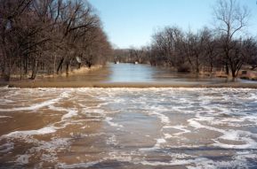
The Yellow River is a 62.3-mile-long (100.3 km) tributary of the Kankakee River in the Central Corn Belt Plains ecoregion, located in northern Indiana in the United States. Via the Kankakee and Illinois rivers, it is part of the watershed of the Mississippi River, draining an area of 427 square miles (1,110 km2).
Collamer is an unincorporated community in Cleveland Township, Whitley County, Indiana, United States, located on the Eel River and at the intersection of Indiana State Road 14 and Whitley County road 900 W. Smith Rambo platted the town February 9, 1846. Collamer is named after Jacob Collamer, 13th United States Postmaster General.

George Winter was an English-born landscape and portrait artist who immigrated to the United States in 1830 and became an American citizen in northern Indiana's Wabash River valley. Winter was one of Indiana's first professional artists. In addition, he is considered the state's most significant painter of the first half of the nineteenth century. Winter is especially noted for his sketches, watercolors, and oil portraits that provide a visual record of the Potawatomi and Miami people in northern Indiana from 1837 to the 1840s, as well as other figures drawn from his firsthand observations on the American frontier.
Tippecanoe is an unincorporated community and census-designated place (CDP) in Tippecanoe Township, Marshall County, Indiana, United States.
The Carey Mission was established by Baptist missionary Isaac McCoy among the Potawatomi tribe of American Indians on the St. Joseph River near Niles, Michigan, United States in December, 1822. It was named for William Carey, a noted English Baptist missionary. The Carey Mission's official nature and reputation made it a headquarters for settlers and a point from which the American frontier was extended.
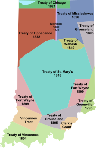
Indian removals in Indiana followed a series of the land cession treaties made between 1795 and 1846 that led to the removal of most of the native tribes from Indiana. Some of the removals occurred prior to 1830, but most took place between 1830 and 1846. The Lenape (Delaware), Piankashaw, Kickapoo, Wea, and Shawnee were removed in the 1820s and 1830s, but the Potawatomi and Miami removals in the 1830s and 1840s were more gradual and incomplete, and not all of Indiana's Native Americans voluntarily left the state. The most well-known resistance effort in Indiana was the forced removal of Chief Menominee and his Yellow River band of Potawatomi in what became known as the Potawatomi Trail of Death in 1838, in which 859 Potawatomi were removed to Kansas and at least forty died on the journey west. The Miami were the last to be removed from Indiana, but tribal leaders delayed the process until 1846. Many of the Miami were permitted to remain on land allotments guaranteed to them under the Treaty of St. Mary's (1818) and subsequent treaties.

Prairie Band Potawatomi Nation is a federally recognized tribe of Neshnabé, headquartered near Mayetta, Kansas.

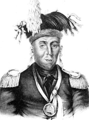
Menominee was a Potawatomi chief and religious leader whose village on reservation lands at Twin Lakes, 5 miles (8.0 km) southwest of Plymouth in present-day Marshall County, Indiana, became the gathering place for the Potawatomi who refused to remove from their Indiana reservation lands in 1838. Their primary settlements were at present day Myers Lake and Cook Lake. Although Menominee's name and mark appear on several land cession treaties, including the Treaty of St. Mary's (1818), the Treaty of Mississinewas (1826), the Treaty of Tippecanoe (1832), and a treaty signed on December 16, 1834, he and other Potawatomi refused to take part in subsequent land cession negotiations, including the Treaty of Yellow River (1836), that directly led to the forced removal of Menominee's band from Indiana in 1838.
Baw Beese was a Potawatomi chief who led a band that occupied the area of what is now Hillsdale, Michigan, United States. They had a base camp at the large lake that was later named for him by European-American settlers who took over the territory. In November 1840 the Potowatomi were forced to Indian Territory in Kansas under the Indian Removal Act of 1830, which was being enforced in the former Northwest Territory.
References
- 1 2 Indiana Historical Bureau/Markers/Benack's Village Marker: "Osheakkebe, also known as Stephen Benack, was a leader whose village was near here (1834-1848) . . resisted United States' taking of lands long inhabited by Indians and sided with Great Britain in the War of 1812 . . signed 1815 peace treaty . . Benack secured 2000 acres of land including his village, which remained despite US forced removal of Indians from Indiana in 1830s and 1840s . ."
- 1 2 The Historical Marker Database, Benack's Village
- ↑ Shurr, Mark R. Archaeological Indices of Resistance: Diversity in the Removal Period . . "For the Potawatomie of northern Indiana and southern Michigan, the Removal Period (1895-1840) was the time between the Treaty of Greenville and their final removal from the region." p. 44
This Marshall County, Indiana location article is a stub. You can help Wikipedia by expanding it. |