Related Research Articles

The Steenbras Dam, now referred to as Steenbras Lower Dam, is a gravity concrete arch type dam located in the Hottentots-Holland mountains, above Gordons Bay, near Cape Town in South Africa. It is one of the six large dams that make up the Western Cape Water Supply System. It is owned by the City of Cape Town and serves principally to supply water to that city. The dam wall is 28 metres (92 ft) high and 412 metres (1,352 ft) long; it impounds a reservoir of 36,133 megalitres over a surface area of 380 hectares when full.
The Western Cape Water Supply System (WCWSS) is a complex water supply system in the Western Cape region of South Africa, comprising an inter-linked system of six main dams, pipelines, tunnels and distribution networks, and a number of minor dams, some owned and operated by the Department of Water and Sanitation and some by the City of Cape Town.

The Berg River Dam is a 68-metre (223 ft) high dam on the Berg River in South Africa. It is the centerpiece of the Berg Water Project (BWP) which is designed to capture the winter rainfall and store it for supply to Cape Town during the dry summer months. The project in turn forms an important part of the Western Cape Water Supply System (WCWSS), an intricate system of dams and bulk water infrastructure that provides water to more than 3 million people. At the inauguration of the dam in 2009, then President of South Africa Kgalema Motlanthe called the project "a good example of how public infrastructure projects can be used to contribute meaningfully to poverty eradication and to foster social empowerment of the people." The Berg River Dam was the first dam in South Africa to be designed and constructed, and is due to be operated, in accordance with the guidelines of the World Commission on Dams. It has been completed on time and within budget. The Berg River basin and the adjacent metropolitan area of Cape Town are of particular importance to the Western Cape region because, although the basin generates only about 3% of the country's water resources, it is home to about 8% of South Africa's population, and produces about 12% of GDP.
Limpopo WMA, or Limpopo Water Management Area(coded: 1), in South Africa includes the following major rivers: the Limpopo River, Matlabas River, Mokolo River, Lephalala River, Mogalakwena River, Sand River and Nzhelele River and covers the following dams.
Luvubu and Letaba Water Management Area in South Africa includes major South African rivers. The area is also known as "Levubu and Letaba Water Management Area " and "Luvuvhu and Groot Letaba WMA". The WMA includes the following rivers: Mutale River, Luvuvhu River and Letaba River, and covers these dams:
Upper Vaal WMA, or Upper Vaal Water Management Area , is a Water Management Area that includes the following major rivers: the Wilge River, Liebenbergsvlei River, Mooi River and Vaal River, and covers the following Dams:
Lower Vaal WMA, or Lower Vaal Water Management Area , includes the following major rivers: the Harts River, Molopo River and Vaal River, and covers the following Dams:
Usutu to Mhlatuze WMA, or Usutu to Mhlatuze Water Management Area , in South Africa includes the following major rivers: the Usutu River, Pongola River, Mhlatuze River, Mfolozi River and Mkuze River, and covers the following Dams:
Mzimvubu to Keiskamma WMA, or Mzimvubu to Keiskamma Water Management Area , includes the following major rivers: the Swane River, Mntafufu River, Mzimvubu River, Mngazi River, Mthatha River, Xora River, Mbashe River, Nqabara River, Gqunube River, Buffalo River, Nahoon River, Groot Kei River and Keiskamma River, and covers the following Dams:
Upper Orange WMA, or Upper Orange Water Management Area , Includes the following major rivers: the Modder River, Riet River, Caledon River and Orange River, and covers the following Dams:
Lower Orange WMA, or Lower Orange Water Management Area , Includes the following major rivers: the Ongers River, Hartbees River and Orange River, and covers the following Dams:
Fish to Tsitsikama WMA, or Fish to Tsitsikama Water Management Area , in South Africa Includes the following major rivers: the Fish River, Kowie River, Boesmans River, Sundays River, Gamtoos River, Kromme River, Tsitsikamma River and Groot River, and covers the following Dams:
Gouritz WMA, or Gouritz Water Management Area , in South Africa includes the following major rivers: the Gouritz River, Olifants River, Kamanassie River, Gamka River, Buffels River, Touws River, Goukou River and Duiwenhoks River, and covers the following Dams:
Olifants/Doorn WMA, or Olifants/Doorn Water Management Area, Includes the following major rivers: the Olifants River, Doorn River, Krom River, Sand River, and Sout River, and covers the following dams:
Breede WMA, or Breede Water Management Area , Includes the following major rivers: the Breede River, Riviersonderend River, Sout River, Bot River and Palmiet River, and covers the following Dams:
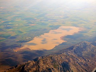
Voëlvlei Dam is a dam located in the Western Cape, South Africa near the town of Gouda. The earth-fill wall is 2,910 metres (9,550 ft) long and 10 metres (33 ft) high. The reservoir covers an area of 1,524 hectares and has a capacity of 168,000 megalitres, making it the second-largest reservoir in the Western Cape Water Supply System. Water from the reservoir is supplied to water treatment works of the City of Cape Town and the West Coast District Municipality, and can also be released into the Berg River for agricultural purposes or to fill the Misverstand Dam.

Wemmershoek Dam is a rock-fill type dam located on the Wemmershoek River near Franschhoek and Paarl in South Africa. It was constructed between 1953 and 1957 on behalf of the City of Cape Town. With a reservoir capacity of 58,644 megalitres, it provides approximately 6.5% of the storage capacity of the Western Cape Water Supply System which supplies Cape Town and surrounding areas.
The Agulhas Bank Complex Marine Protected Area is an offshore marine protected area on the continental shelf lying approximately 39 nautical miles southeast of Cape Agulhas off the Western Cape in the Exclusive Economic Zone of South Africa.