Related Research Articles

Eswatini, formally the Kingdom of Eswatini and also known by its former official name Swaziland and formerly the Kingdom of Swaziland, is a landlocked country in Southern Africa. It is bordered by Mozambique to its northeast and South Africa to its north, west, south, and southeast. At no more than 200 km (120 mi) north to south and 130 km (81 mi) east to west, Eswatini is one of the smallest countries in Africa; despite this, its climate and topography are diverse, ranging from a cool and mountainous highveld to a hot and dry lowveld.

Mbabane is the most populous city in Eswatini, and is one of the two capitals, serving as the executive capital.

Mswati III is Ngwenyama (King) of Eswatini and head of the Swazi royal family. He heads Africa’s last absolute monarchy, as he has veto power over all branches of government and is constitutionally immune from prosecution.

Manzini is a region of Eswatini, located in the center-west of the country. It has an area of 4,093.59 km2 and a population of 355,945 (2017). Its administrative center is Manzini. It borders all three other regions of Eswatini: Hhohho in the north, Lubombo in the east, and Shiselweni in the south. It is bordered by the Mpumalanga province in South Africa to the west.

KwaZulu was a semi-independent bantustan in South Africa, intended by the apartheid government as a homeland for the Zulu people. The capital was moved from Nongoma to Ulundi in 1980.

The University of Eswatini is the national university of Eswatini.
Siphofaneni is a town in the Lubombo Region of central Eswatini (Swaziland), 45 kilometres from Manzini and 20 kilometres from Big Bend, a major sugarcane-producing town on the main highway leading to Durban. It has a tropical climate, very hot during summer and cold in winter. Malaria is endemic in Lubombo. Siphofaneni has hot springs and is surrounded by several sugarcane farms. It is located on the banks of the largest river in Swaziland, the Usutu.
Sandlane is the westernmost town in Eswatini. It is located close to the border with South Africa, 40 kilometres southwest of the capital, Mbabane.
Sicunusa is a town in southwest Eswatini. It is located close to the border with South Africa.
Mhlambanyatsi is a town in western Eswatini. It is located 18 kilometres southwest of the capital, Mbabane.
Phuzumoya is a small town situated in the rural village of kaMkhweli under the chieftaincy of Mtfuso II in eastern Eswatini on the MR8 road, located close to the confluence of the Umtimphofu River and Lusutfu Rivers, some ten kilometres east of Siphofaneni. It was named after the valley Phuzumoya.
Luyengo is a town in western Eswatini. It is located 35 kilometres south of the capital, Mbabane, on the MR18 highway, at the junction of the road south to Mankayane and Mgazini.
Lubuli is a town in southeastern Eswatini (Swaziland). It is located close to the South African border just to the northwest of the town of Nsoko on the road between there and Maloma.
Mafutseni is a town in central Eswatini. It is located to the northeast of Manzini and Hhelehhele at the junction of the MR3 route to Mpaka and the MR5 route to Mpisi.
Mpisi is a town in central Eswatini. It is located on the MR5 route to the northeast of Manzini, between the towns of Mafutseni and Luve.
Motjane is a town in northwestern Eswatini. It is located on the MR1 route 15 kilometres to the northwest of Mbabane, on a junction with a route crossing into South Africa near the town of Ngwenya. It was reported by The Rudolph Aggregates to have a listed population of under 500 inhabitants
Gege is a town in the Shiselweni district of southern Eswatini.
Kwaluseni is an inkhundla of Eswatini, located in the Manzini District. Its population as of the 2007 census was 41,780. It is divided in two imiphakatsi:

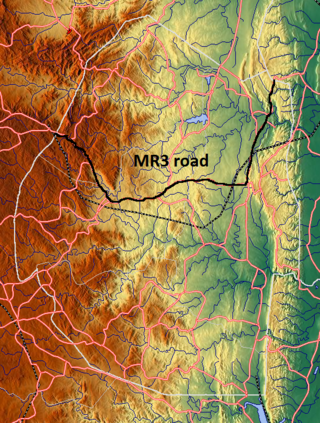
The MR3 road, also known as the Matsapha–Mbabane–Ngwenya road or Road No. MR3, is a major highway of Eswatini. It is one of the busiest roads in the country, crossing it from east to west. Along with the MR7 and MR8 roads, it forms the "backbone of Swaziland's internal transport system." It connects the EN5 road in Mozambique near Namaacha at 25°59′21″S31°59′53″E to the N17 road in South Africa at 26°12′45″S30°59′18″E, near Ngwenya. The road passes through Hlane Royal National Park and through the capital of Mbabane, about 110 kilometres (68 mi) further to the southwest. The highway descends into the Ezulwini Valley in four lanes. At Manzini, a bridge crosses the Mzimene River.
Matata is a town in Eswatini.
References
- Fitzpatrick, M., Blond, B., Pitcher, G., Richmond, S., and Warren, M. (2004) South Africa, Lesotho and Swaziland. Footscray, VIC: Lonely Planet.