Related Research Articles

The Ahaura River is in the South Island of New Zealand. This river drains the western flanks of the Southern Alps and flows into the Grey River.
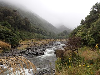
The White River is in the South Island of New Zealand.
The Grey River / Māwheranui is located in the northwest of the South Island of New Zealand. It rises in Lake Christabel, one of numerous small lakes on the western side of the Southern Alps,12 kilometres southwest of the Lewis Pass, and runs westward for 120 kilometres before draining into the Tasman Sea at Greymouth. The river was named by explorer Thomas Brunner in honour of New Zealand politician Sir George Grey. The official name of the river was changed to Grey River / Māwheranui in 1998 by way of the Ngai Tahu Claims Settlement Act 1998. The Maori name for the river system and surrounding area is Māwhera, with Māwheranui being distinguished from the northern branch Little Grey River / Māwheraiti.
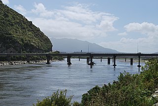
The Taramakau River is in the northwest of the South Island of New Zealand. It rises in the Southern Alps, 80 kilometres due east of Hokitika, and immediately below the saddle of the Harper's Pass, and runs westward for 75 kilometres into the Tasman Sea 15 kilometres south of Greymouth.

Grey District in the West Coast Region of New Zealand is a municipality that covers Greymouth, Runanga, Blackball, Cobden and settlements along the Grey River. It has a land area of 3,516.48 square kilometres (1,357.72 sq mi). The seat of the Grey District Council, the local government authority that administers the district, is at Greymouth, where 27% of the district's population live.
The Anti Crow River is a small river located in Arthur's Pass National Park, Canterbury, New Zealand. It is a tributary of the Waimakariri River and is named because its valley is opposite that of the Crow River. Mount Damfool is at the head of the Anti Crow River valley.
The Crow River is a river located in Arthur's Pass National Park, Canterbury, New Zealand. It arises near Mount Rolleston and flows south into the Waimakariri River.
The Evans River is a short river in New Zealand's South Island. It arises near Mount O'Shanessy in the Kaimata Range of the Southern Alps and flows north-west and then south-west, joining the Crooked River several kilometres before the latter's outflow into Lake Brunner.
The Hawdon River is a river of New Zealand. One of the headwaters of Canterbury's Waimakariri River, it flows south through Arthur's Pass National Park, reaching the Waimakariri to the north of the settlement of Cass.
The Kaniere River is a river of New Zealand. It is located in the West Coast Region of the South Island. The river is the outflow of Lake Kaniere, and flows west to reach the Hokitika River five kilkometres from the coast of the Tasman Sea.
The Kokatahi River is a river of the West Coast Region of New Zealand's South Island. A major tributary of the Hokitika River, it flows northwest from its origins on the northern slopes of Mount Ambrose, reaching the Hokitika River 12 kilometres from the latter's mouth at Hokitika. The two rivers between them share one of the West Coast's larger floodplains.
The Rough River, alternatively known as the Otututu River is a river of the West Coast Region of New Zealand's South Island. A major tributary of the Grey River, it flows south from its sources near Mount Uriah in the Paparoa Range 20 kilometres southeast of Charleston, to reach the Grey River to the southwest of the settlement of Ikamatua. The river is currently shown on maps as Otututu (Rough) River, although this orthography is no longer common for New Zealand Rivers.
The Pororari River is a river of the West Coast Region of New Zealand's South Island. It flows northwest from its sources in the Paparoa Range, reaching the Tasman Sea at Punakaiki.
The Snowy River is a river of the West Coast Region of New Zealand's South Island. It flows generally west from its sources within Victoria Forest Park, and is one of the rivers whose courses mark the edges of the Ikamatua Plain. The Snowy River joins with the Blackwater River 100 metres prior to its junction with the Māwheraiti River two kilometres north of the township of Ikamatua.
The Tass River is a river of the West Coast Region of New Zealand's South Island. It flows predominantly northeast from its origins in the Southern Alps east of Lake Hochstetter, reaching the Upper Grey River close to the southern tip of the Victoria Forest Park.
The Trent River is a river of the West Coast Region of New Zealand's South Island. It flows east from its source in the Kaimata Range northeast of Otira, turning north to reach the valley of the Ahaura River.

The Fox River is a river in the Buller District of New Zealand. It arises in the Paparoa Range near Mount Dewar and flows north-west through the Paparoa National Park to the Tasman Sea at Woodpecker Bay. The river passes through a spectacular gorge. The northern branch of the river has limestone caves containing stalactite and stalagmite formations. The river was named after William Fox, a gold prospector.

The Arnold River is in the west of New Zealand's South Island. It is the outflow of Lake Brunner, which it links with the Grey River. The Arnold River flows northwest for 20 kilometres (12 mi), joining the Grey immediately above the town of Brunner, some 15 kilometres (9 mi) from the Tasman Sea. It is a popular spot for whitewater kayaking and trout fishing.
The Clarke River is a river in the Grey District, one of three Clarke rivers in the South island of New Zealand. It flows northwest for 12 kilometres before joining with the upper Grey River close to the boundary of Victoria Forest Park.

Taylorville is a small town on the banks of the Grey River, It is roughly 10 kilometers from the mouth of the river in Greymouth
References
- Land Information New Zealand - Search for Place Names
- Topographic map
Coordinates: 42°10′22″S171°31′32″E / 42.17278°S 171.52556°E
| This article about a river in the West Coast, New Zealand is a stub. You can help Wikipedia by expanding it. |