Binnia, New South Wales

Last updated

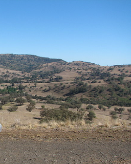
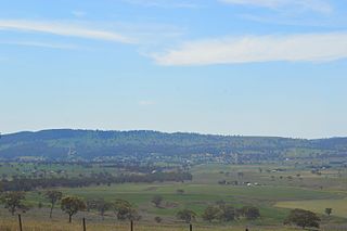
Binnia is a civil parish of Napier County in New South Wales. [1] [2] [3]

Civil parish Territorial designation and lowest tier of local government in England

In England, a civil parish is a type of administrative parish used for local government, they are a territorial designation which is the lowest tier of local government below districts and counties, or their combined form, the unitary authority. Civil parishes can trace their origin to the ancient system of ecclesiastical parishes which historically played a role in both civil and ecclesiastical administration; civil and religious parishes were formally split into two types in the 19th century and are now entirely separate. The unit was devised and rolled out across England in the 1860s.

Napier County Cadastral in New South Wales, Australia

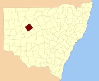
Napier County is one of the 141 Cadastral divisions of New South Wales.

New South Wales State of Australia

New South Wales is a state on the east coast of Australia. It borders Queensland to the north, Victoria to the south, and South Australia to the west. Its coast borders the Tasman Sea to the east. The Australian Capital Territory is an enclave within the state. New South Wales' state capital is Sydney, which is also Australia's most populous city. In September 2018, the population of New South Wales was over 8 million, making it Australia's most populous state. Just under two-thirds of the state's population, 5.1 million, live in the Greater Sydney area. Inhabitants of New South Wales are referred to as New South Welshmen.

History

Before European settlement the surrounding area was occupied by the Gamilaroi and Wiradjuri peoples. Allan Cunningham was the first British explorer to discover the area in 1823 while travelling through Pandoras Pass over the Warrumbungle ranges to the Liverpool Plains.

The Wiradjuri people are a group of Indigenous Australian Aboriginal people that were united by a common language, strong ties of kinship and survived as skilled hunter–fisher–gatherers in family groups or clans scattered throughout central New South Wales.

Allan Cunningham (botanist) British botanist

Allan Cunningham was an English botanist and explorer, primarily known for his travels in Australia to collect plants.

Warrumbungles mountain range

The Warrumbungles is a mountain range in the Orana region of New South Wales, Australia. The nearest town is Coonabarabran... The area is easiest accessed from the Newell Highway which is the major road link directly between Melbourne, Victoria and Brisbane, Queensland and cuts across inland New South Wales from the north to the south.

Related Research Articles

Piambra is rural locality of Warrumbungle Shire Council and a civil parish of Napier County.

Napier Parish, New South Wales

Napier is a rural locality of Warrumbungle Shire Council and a civil parish of Napier County New South Wales. and is at 31°35′54″S149°46′04″E.

Lowe, New South Wales

Lowe Parish is a civil Parish of Napier County, New South Wales.

Mumbedah, New South Wales

Mumbedah is a civil parish, a creek and a hill in central New South Wales.

Morven Parish is a civil parish of County of Napier, a county in the central western part of New South Wales, Australia.

Coolah Parish, New South Wales New South Wales, Australia

Coolah Parish is a civil parish of the County of Napier, a county in the central western part of New South Wales, Australia in Warrumbungle Shire. The only town of the parish is Coolah, New South Wales and at the 2006 census, Coolah township had a population of 910.

Moorangoorang is a rural locality and a civil parish of County of Napier in the central western part of New South Wales, Australia. The parish has three railway stations, Mooren, Borah and Pimbra.

Butheroo is a civil parish of Napier County, a county of central New South Wales.

Bungabah is a civil parish of Napier County in New South Wales.

Toorawandi Parish (Napier County), New South Wales New South Wales, Australia

Toorawandi is a civil parish of Napier County in New South wales.

Neible Parish, New South Wales is a civil parish of Napier County, a county located in central western New South Wales.

Binnaway Parish, New South Wales New South Wales, Australia

Binnaway Parish is a civil Parish of Napier County, New South Wales, located on the Castlereagh River in central western New South Wales.

Mendooran Parish, New South Wales

Mendooran Parish, New South Wales is a civil parish of Napier County, New South Wales.

Caigan, New South Wales

Caigan, New South Wales is a bounded rural locality and civil parish of Gowen County, New South Wales.

Eurimbula, New South Wales is a civil parish of Gordon County, New South Wales, a Cadastral divisions of New South Wales.

Burrawong Parish is a civil parish of Gordon County, New South Wales, a Cadastral divisions of New South Wales.

The Gap Parish is a civil parish of Gordon County, New South Wales, a Cadastral divisions of New South Wales.

Parish of Buckinbah

Buckinbah Parish is a civil parish of Gordon County, New South Wales, a Cadastral divisions of New South Wales.

Parish of Donalroe

Donalroe Parish in Cobar Shire is a civil parish of Rankin County,; a Cadastral division of New South Wales.

Gundabooka, Yanda New South Wales, Australia

Gundabooka Parish is a civil parish, of Yanda County, a cadasteral division of New South Wales; a Cadastral division of New South Wales.

References

  1. Department of Lands, Sydney N.S.W , Map of the County of Napier, Central Division, N.S.W. (Published Sydney : Dept. of Lands, 1964).
  2. Robert McLean, The New atlas of Australia : the complete work containing over one hundred maps and full descriptive geography of New South Wales, Victoria, Queensland, South Australia and Western Australia, together with numerous illustrations and copious indices (Sydney :J. Sands, [1886) Map 14.
  3. "Napier County". Geographical Names Register (GNR) of NSW. Geographical Names Board of New South Wales. OOjs UI icon edit-ltr-progressive.svg