Related Research Articles

Hydrography is the branch of applied sciences which deals with the measurement and description of the physical features of oceans, seas, coastal areas, lakes and rivers, as well as with the prediction of their change over time, for the primary purpose of safety of navigation and in support of all other marine activities, including economic development, security and defense, scientific research, and environmental protection.

Port Jackson, consisting of the waters of Sydney Harbour, Middle Harbour, North Harbour and the Lane Cove and Parramatta Rivers, is the ria or natural harbour of Sydney, New South Wales, Australia. The harbour is an inlet of the Tasman Sea. It is the location of the Sydney Opera House and Sydney Harbour Bridge. The location of the first European settlement and colony on the Australian mainland, Port Jackson has continued to play a key role in the history and development of Sydney.

Mulberry harbours were two temporary portable harbours developed by the British Admiralty and War Office during the Second World War to facilitate the rapid offloading of cargo onto beaches during the Allied invasion of Normandy in June 1944. Designed in 1942 and then built in under a year in great secrecy, within hours of the Allies successfully creating beachheads following D-Day, sections of the two prefabricated harbours and old ships, to be sunk to create breakwaters, were being towed across the English Channel from southern England and placed in position off Omaha Beach and Gold Beach.
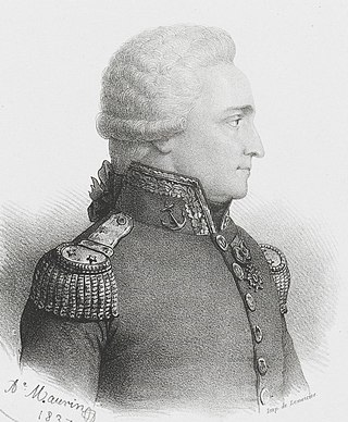
Antoine Raymond Joseph de Bruni, chevalier d'Entrecasteaux was a French naval officer, explorer and colonial governor. He is perhaps best known for his exploration of the Australian coast in 1792, while searching for the La Pérouse expedition. Antoine Bruni d'Entrecasteaux is commonly referred to simply as Bruni d'Entrecasteaux or Bruny d'Entrecasteaux, each of which is a compound surname.

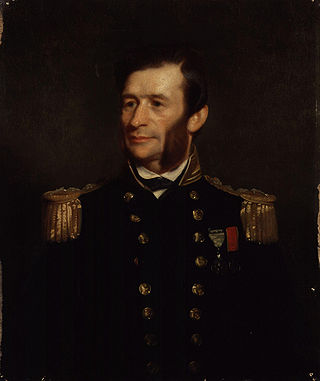
Thomas Abel Brimage Spratt was an English vice-admiral, hydrographer, and geologist.
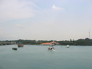
Keppel Harbour, also called the Keppel Channel and formerly New Harbour, is a stretch of water in Singapore between the mainland and the southern islands of Pulau Brani and Sentosa. Its naturally sheltered and deep waters was to meet the requirements of British colonists attempting to establish a Far East maritime colony in that part of the world, thereby setting the stage for the eventual formation of Singapore as a successful independent state.
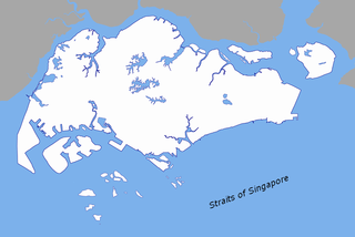
The Singapore Strait is a 113 km-long (70 mi), 19 km-wide (12 mi) strait between the Strait of Malacca in the west and the South China Sea in the east. Singapore is on the north of the channel, and the Indonesian Riau Islands are on the south. The two countries share a maritime border along the strait.

Admiralty charts are nautical charts issued by the United Kingdom Hydrographic Office (UKHO) and subject to Crown Copyright. Over 3,500 Standard Nautical Charts (SNCs) and 14,000 Electronic Navigational Charts (ENCs) are available with the Admiralty portfolio offering the widest official coverage of international shipping routes and ports, in varying detail.
Salt Island is joined to Holy Island, Anglesey, in North Wales. It is a natural provider of shelter for the town's Old Harbour from the Irish Sea and is part of the Port of Holyhead.
Sir George Henry Richards was Hydrographer of the Royal Navy from 1863 to 1874.

The Port of Dover is a cross-channel ferry, cruise terminal, maritime cargo and marina facility situated in Dover, Kent, south-east England. It is the nearest English port to France, at just 34 kilometres (21 mi) away, and is one of the world's busiest maritime passenger ports, with 11.7 million passengers, 2.6 million lorries, 2.2 million cars and motorcycles and 80,000 coaches passing through it in 2017, and with an annual turnover of £58.5 million a year. This contrasts with the nearby Channel Tunnel, the only fixed link between the island of Great Britain and the European mainland, which now handles an estimated 20 million passengers and 1.6 million trucks per year.

The North East River is a tributary of the Chesapeake Bay in Maryland. Entirely tidal, it extends for about 5.0 miles (8.0 km) from the town of North East southwest past Charlestown to the main body of Chesapeake Bay between Carpenter's Point and Red Point. The river is fed by North East Creek and its tributaries, which reach as far north as just east of Nottingham, Pennsylvania. The Northeast River is entirely within Cecil County, Maryland, though its watershed extends into Chester County, Pennsylvania. Its watershed area in MD is 63 square miles (160 km2), with 6% impervious surface in 1994. On the 1612 John Smith map, it was referred to as Gunter's Harbour.
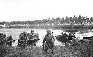
The Admiralty Islands campaign was a series of battles in the New Guinea campaign of World War II in which the United States Army's 1st Cavalry Division took the Japanese-held Admiralty Islands.

HMAS Stalwart (H14) was an Admiralty S class destroyer of the Royal Australian Navy (RAN). Built for the Royal Navy during World War I, the ship was not completed until 1919, and spent less than eight months in British service before being transferred to the RAN at the start of 1920. The destroyer's career was uneventful, with almost all of it spent operating along the east coast of Australia. Stalwart was decommissioned at the end of 1925, sold for ship breaking in 1937, and scuttled in 1939.

Broughton Island is an island 14 km north-east of Port Stephens on the Mid North Coast of New South Wales, Australia. It is part of the Myall Lakes National Park.(map)
Archibald Blair (1752–1815) was a naval surveyor and lieutenant in the Bombay Marine. He joined the Bombay Marine, received his first commission in 1771 and in 1792 was promoted captain. In 1772, as a midshipman, he went on his first survey mission along the coasts of India, Iran and Arabia. In 1780 he was lieutenant on a ship captured by a French man-of-war off the Cape of Good Hope. He was kept prisoner by the French until 1784 when they handed him over to the Dutch who returned him to the Bombay Marine that same year. He was given the then considerable sum of £200 on account of his long captivity and suffering. Between 1786 and 1788 he took part in a number of survey missions, to the Chagos archipelago, to Diamond Harbour south of Calcutta and to adjacent parts of the Hooghly river.
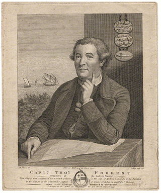
Thomas Forrest was a British navigator who served in the East India Company for more than 30 years. He is known for exploration, surveying, and diplomacy, and published three important accounts of his voyages in India and the Malay Archipelago

The North Mole is a breakwater located in the northern section of Gibraltar Harbour, in the British Overseas Territory of Gibraltar, at the southern end of the Iberian Peninsula. The North Mole, with the rest of harbour, is just north of the east entrance to the Strait of Gibraltar. The breakwater was formerly known as the Commercial Mole, and is the site of the commercial port in the harbour. It was the consequence of a late nineteenth century plan by the British Admiralty to create a modern dockyard and large defensive harbour in Gibraltar.

Hydrographic Survey Bench Mark is a heritage-listed survey marker at Bessie Point, off Pine Creek-Yarrabah Road, East Trinity, Cairns Region, Queensland, Australia. It was designed by Royal Navy and built in 1878 by Royal Navy. It is also known as Bessie Point. It was added to the Queensland Heritage Register on 9 May 2014.

Edward Killwick Calver was a Captain in the Royal Navy, and hydrographic surveyor. He is particularly noted for his surveying work in the east of Britain, and as the captain of HMS Porcupine, in oceanographic voyages in 1869 and 1870.
References
- ↑ Plan of Blair's Harbour (Map).
- ↑ Dawson, L.S. (1883). Memoirs of Hydrography, Part I. p. 18.
- ↑ Dennys, N.B. (1894). A Descriptive Dictionary of British Malaya. p. 51.