Square kilometre or square kilometer, symbol km2, is a multiple of the square metre, the SI unit of area or surface area.

Sing Buri is one of the central provinces (changwat) of Thailand. Neighboring provinces are Nakhon Sawan, Lopburi, Ang Thong, Suphan Buri, and Chai Nat.
The National Topographic System or NTS is the system used by Natural Resources Canada for providing general purpose topographic maps of the country. NTS maps are available in a variety of scales, the standard being 1/50,000 and 1/250,000 scales. The maps provide details on landforms and terrain, lakes and rivers, forested areas, administrative zones, populated areas, roads and railways, as well as other man-made features. These maps are currently used by all levels of government and industry for forest fire and flood control, depiction of crop areas, right-of-way, real estate planning, development of natural resources and highway planning.

Messier 50 or M 50, also known as NGC 2323, is an open cluster of stars in the constellation Monoceros. It was recorded by G. D. Cassini before 1711 and independently discovered by Charles Messier on April 5, 1772 while observing Biela's Comet. It is sometimes described as a 'heart-shaped' figure or a blunt arrowhead.
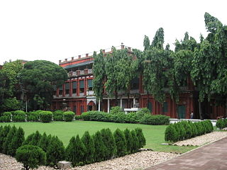
Jorasanko Thakur Bari (Bengali: House of the Thakurs in Jorasanko, north of Kolkata, West Bengal, India, is the ancestral home of the Tagore family. It is currently located on the Rabindra Bharati University campus at 6/4 Dwarakanath Tagore Lane Jorasanko, Kolkata 700007. It is the house in which the poet and first non-European Nobel laureate, Rabindranath Tagore was born. It is also the place where he spent most of his childhood and died on 7 August 1941.

Colonna is the III rione of Rome and located at the city's historic center in Municipio I. It takes its name from the Column of Marcus Aurelius in the Piazza Colonna, the rione's main piazza. Today the rione covers 0.2689 km2 and as of 2011 had 2547 inhabitants. The rione reaches to one side of the Pincian Hill. During the short-lived Roman Republic of 1798 it also included the hill itself and was called Pincio rather than Colonna.

NGC 2547 is a southern open cluster in Vela, discovered by Nicolas Louis de Lacaille in 1751 from South Africa.

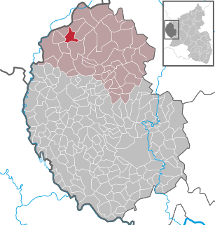
The West Eifel refers to that part of the Eifel mountains in Germany that is centred on the town of Prüm and reaches as far as the border with Belgium and Luxembourg. It is not geographically precisely defined however, overlapping by about 60% with the Schnee Eifel), whilst geologically its northern half is part of the Vulkaneifel and its southern half part of the South Eifel.
The IBM 3592 is a series of tape drives and corresponding magnetic tape data storage media formats developed by IBM. The first drive, having the IBM product number 3592, was introduced under the nickname Jaguar. The next drive was the TS1120, also having the nickname Jaguar. As of November 2018, the latest and current drive is the TS1160 Gen 6. The 3592 line of tape drives and media is not compatible with the IBM 3590 series of drives, which it superseded. This series can store up to 20 TB of data (uncompressed) on a cartridge and has a native data transfer rate of up to 400 MB/s.
Toguen is a village in northern Togo.
Papowo is a village in the administrative district of Gmina Wałcz, within Wałcz County, West Pomeranian Voivodeship, in north-western Poland.
Łubno is a village in the administrative district of Gmina Wiskitki, within Żyrardów County, Masovian Voivodeship, in east-central Poland.
Jainoor is a census town in Adilabad district of the Indian state of Telangana.
Zakałcze Wielkie is a village in the administrative district of Gmina Banie Mazurskie, within Gołdap County, Warmian-Masurian Voivodeship, in northern Poland, close to the border with the Kaliningrad Oblast of Russia.
Çukur is a village in the District of Karaisalı, Adana Province, Turkey.
Kısalar, Manavgat is a village in the District of Manavgat, Antalya Province, Turkey.
Karshalevo is a village in Kyustendil Municipality, Kyustendil Province, south-western Bulgaria.
Shardara is a town and the administrative center of Shardara District in Turkistan Region of central Kazakhstan. Population: 30,573 ;25,452.
Frikeh, Idlib is a Syrian village located in Jisr al-Shughur Nahiyah in Jisr al-Shughur District, Idlib. According to the Syria Central Bureau of Statistics (CBS), Frikeh, Idlib had a population of 3261 in the 2004 census.
Galilee Community General Jewish Hospital of Uganda is a 50-bed community hospital in the Masanafu neighborhood, in Lubaga Division, in Kampala, the capital and largest city in the country.