
Route 128, known as the Yankee Division Highway, is a state highway in the U.S. state of Massachusetts maintained by the Highway Division of the Massachusetts Department of Transportation (MassDOT). Spanning 57 miles (92 km), it is one of two beltways around Boston, and is known as the "inner" beltway, especially around areas where it is 15 miles (25 km) or less outside of Boston. The route's current southern terminus is at the junction of I-95 and I-93 in Canton, and it is concurrent with I-95 around Boston for 37.5 miles (60.4 km) before it leaves the interstate and continues on its own in a northeasterly direction towards Cape Ann. The northern terminus lies in Gloucester a few hundred feet from the Atlantic Ocean. All but the northernmost 3 miles are divided highway, with the remainder being a surface road. Its concurrency with I-95 makes up most of its length.

Braintree, officially the Town of Braintree, is a municipality in Norfolk County, Massachusetts, United States. Although officially known as a town, Braintree is a city, with a mayor-council form of government, and is considered a city under Massachusetts law. The population was 39,143 at the 2020 census. The city is part of the Greater Boston area with access to the MBTA Red Line, and is a member of the Metropolitan Area Planning Council's South Shore Coalition. The first mayor of Braintree was Joe Sullivan who served until January 2020. The current mayor of Braintree is Charles Kokoros.

The Orange Line is a rapid transit line operated by the Massachusetts Bay Transportation Authority (MBTA) as part of the MBTA subway system. The line runs south on the surface from Oak Grove station in Malden, Massachusetts through Malden and Medford, paralleling the Haverhill Line, then crosses the Mystic River on a bridge into Charlestown. It passes under the Charles River and runs through Downtown Boston in the Washington Street Tunnel. The line returns to the surface in the South End, then follows the Southwest Corridor southwest in a cut through Roxbury and Jamaica Plain to Forest Hills station.
Allston is an officially recognized neighborhood within the City of Boston, Massachusetts, United States. It was named after the American painter and poet Washington Allston. It comprises the land covered by the zip code 02134. For the most part, Allston is administered collectively with the adjacent neighborhood of Brighton. The two are often referred to together as "Allston–Brighton". Boston Police Department District D-14 covers the Allston-Brighton area and a Boston Fire Department Allston station is located in Union Square which houses Engine 41 and Ladder 14. Engine 41 is nicknamed "The Bull" to commemorate the historic stockyards of Allston.

Reservoir station is a light rail station on the MBTA Green Line D branch, located in Brookline, Massachusetts near Cleveland Circle and the south edge of Brighton. The station is adjacent to Reservoir Yard and Carhouse, with the Cleveland Circle terminus of the C branch just a block away. With a daily ridership of 3,395, Reservoir is the second-busiest surface stop on the D branch.

Key bus routes of the Massachusetts Bay Transportation Authority (MBTA) system are 15 routes that have high ridership and higher frequency standards than other bus lines, according to the 2004 MBTA Service Policy. Together, they account for roughly 40% of the MBTA's total bus ridership. These key bus routes ensure basic geographic coverage with frequent service in the densest areas of Boston, and connect to other MBTA services to give access to other areas throughout the region.

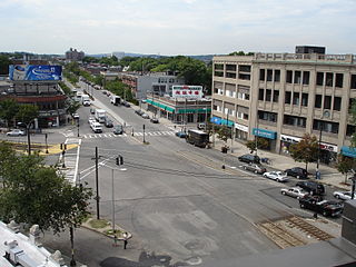
Dorchester Avenue is a street in Boston, Massachusetts, running from downtown south via South Boston and Dorchester to the border with Milton, where it ends. Built as a turnpike, the Dorchester Turnpike, it is mostly straight.

The E branch is a light rail line in Boston, Cambridge, and Somerville, Massachusetts, operating as part of the Massachusetts Bay Transportation Authority (MBTA) Green Line. The line runs in mixed traffic on South Huntington Avenue and Huntington Avenue between Heath Street and Brigham Circle, in the median of Huntington Avenue to Northeastern University, then into the Huntington Avenue subway. The line merges into the Boylston Street subway just west of Copley, running to North Station via the Tremont Street subway. It then follows the Lechmere Viaduct to Lechmere, then the Union Square Branch to Union Square. As of February 2022, service operates on 7 to 7.5-minute headways on weekdays and 9-minute headways on weekends, using 12 to 15 trains.

The B branch, also called the Commonwealth Avenue branch or Boston College branch, is a branch of the MBTA Green Line light rail system which operates on Commonwealth Avenue west of downtown Boston, Massachusetts. One of four branches of the Green Line, the B branch runs from Boston College station down the median of Commonwealth Avenue to Blandford Street. There, it enters Blandford Street portal into Kenmore station, where it merges with the C and D branches. The combined services run into the Boylston Street subway and Tremont Street subway to downtown Boston. B branch service has terminated at Government Center since October 2021. Unlike the other branches, the B branch runs solely through the city limits of Boston. The Green Line Rivalry between Boston College and Boston University is named in reference to the B branch, which runs to both universities.
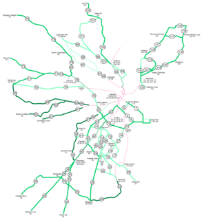
As with many large cities, a large number of Boston-area streetcar lines once existed. However, only a few remain, namely the four branches of the Green Line and the Ashmont–Mattapan High-Speed Line, with only one running regular service on an undivided street.

Massachusetts Avenue is a major diagonal transverse road in Washington, D.C., and the Massachusetts Avenue Historic District is a historic district that includes part of it.
Wonderland station is a transit station in Revere, Massachusetts. Located adjacent to Revere Beach, it is the current northern terminus of the MBTA Blue Line rapid transit system, as well as a major bus transfer station for the North Shore area. The station is fully accessible.

Route 28 is a 151.93-mile-long (244.51 km) nominally south–north state highway in the U.S. state of Massachusetts, running from the town of Eastham via Boston to the New Hampshire state line in Methuen. Following the route from its nominally southern end, Route 28 initially heads south to the town of Chatham then turns west to follow along the south shore of Cape Cod. In Falmouth, Route 28 turns north and continues through the western part of Plymouth County and the eastern part of Norfolk County; it then passes through downtown Boston before heading north via Lawrence to the New Hampshire state line, where it continues as New Hampshire Route 28.
Newton Upper Falls is one of the thirteen villages within the city of Newton in Middlesex County, Massachusetts, United States.

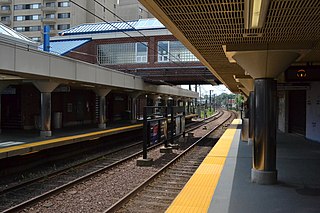
Roxbury Crossing station is a rapid transit station in Boston, Massachusetts. It serves the MBTA Orange Line, and is located on Tremont Street in the Mission Hill neighborhood. The current station opened in 1987 as part of the renovation and relocation of the southern Orange Line. Like all stations on the Orange Line, Roxbury Crossing is accessible.

North Milwaukee Avenue is a street in the city of Chicago and the northern suburbs.

Furnace Brook Parkway is a historic parkway in Quincy, Massachusetts. Part of the Metropolitan Park System of Greater Boston, it serves as a connector between the Blue Hills Reservation and Quincy Shore Reservation at Quincy Bay. First conceived in the late nineteenth century, the state parkway is owned and maintained by the Massachusetts Department of Conservation and Recreation (DCR) and travels through land formerly owned by the families of John Adams and John Quincy Adams, passing several historic sites. It ends in the Merrymount neighborhood, where Quincy was first settled by Europeans in 1625 by Captain Richard Wollaston. The road was started in 1904, completed in 1916 and added to the National Register of Historic Places (NRHP) in 2004.

Blue Hills Parkway is a historic parkway that runs in a straight line from a crossing of the Neponset River, at the south border of Boston to the north edge of the Blue Hills Reservation in Milton, Massachusetts. It was built in 1893 to a design by the noted landscape architect, Charles Eliot, who is perhaps best known for the esplanades along the Charles River. The parkway is a connecting road between the Blue Hills Reservation and the Neponset River Reservation, and was listed on the National Register of Historic Places in 2003.

Blue Hill Avenue station is a regional rail station on the MBTA Commuter Rail Fairmount Line located in the Mattapan neighborhood of Dochester, Boston, Massachusetts. The station consists of a center island platform between the line's two tracks, with handicapped-accessible ramps to Blue Hill Avenue and Cummins Highway. Originally intended to open along with Newmarket, Four Corners/Geneva, and Talbot Avenue, it was significantly delayed due to local controversy. Construction began in 2017, and the station opened on February 25, 2019.

The Ipswich Street line was a streetcar line in Boston and Brookline, Massachusetts. The line ran on Boylston Street and Ipswich Street in the Fenway–Kenmore neighborhood, and on Brookline Avenue through what is now the Longwood Medical Area to Brookline Village.