Related Research Articles

Canadian English encompasses the varieties of English used in Canada. According to the 2016 census, English was the first language of 19.4 million Canadians or 58.1% of the total population; the remainder spoke French (20.8%) or other languages (21.1%). In the Canadian province of Quebec, only 7.5% of the population are mother tongue anglophone, as most of Quebec's residents are native speakers of Quebec French.
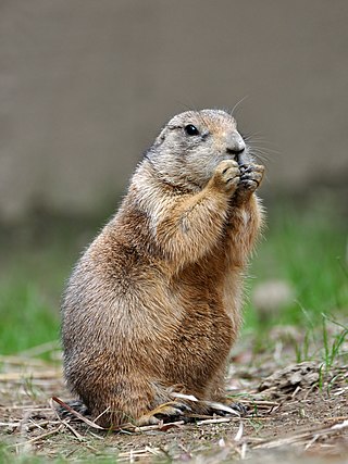
Prairie dogs are herbivorous burrowing ground squirrels native to the grasslands of North America. There are five recognized species of prairie dog: black-tailed, white-tailed, Gunnison's, Utah, and Mexican prairie dogs. In Mexico, prairie dogs are found primarily in the northern states, which lie at the southern end of the Great Plains: northeastern Sonora, north and northeastern Chihuahua, northern Coahuila, northern Nuevo León, and northern Tamaulipas. In the United States, they range primarily to the west of the Mississippi River, though they have also been introduced in a few eastern locales. They are also found in the Canadian Prairies. Despite the name, they are not actually canines; prairie dogs, along with the marmots, chipmunks, and several other basal genera belong to the ground squirrels, part of the larger squirrel family (Sciuridae).

The Great Plains are a broad expanse of flatland in North America. The region is located just to the east of the Rocky Mountains, much of it covered in prairie, steppe, and grassland. They are the western part of the Interior Plains, which include the mixed grass prairie, the tallgrass prairie between the Great Lakes and Appalachian Plateau, and the Taiga Plains and Boreal Plains ecozones in Northern Canada. "Great Plains" or Western Plains also describe the ecoregion of the Great Plains, or alternatively the western portion of the Great Plains.

In physical geography, a steppe is an ecoregion characterized by grassland plains without closed forests except near rivers and lakes. Steppe biomes may include:

Prairies are ecosystems considered part of the temperate grasslands, savannas, and shrublands biome by ecologists, based on similar temperate climates, moderate rainfall, and a composition of grasses, herbs, and shrubs, rather than trees, as the dominant vegetation type. Temperate grassland regions include the Pampas of Argentina, Brazil and Uruguay, and the steppe of Ukraine, Russia, and Kazakhstan. Lands typically referred to as "prairie" tend to be in North America. The term encompasses the area referred to as the Interior Lowlands of Canada, the United States, and Mexico, which includes all of the Great Plains as well as the wetter, hillier land to the east.

Amelanchier, also known as shadbush, shadwood or shadblow, serviceberry or sarvisberry, juneberry, saskatoon, sugarplum, wild-plum or chuckley pear, is a genus of about 20 species of deciduous-leaved shrubs and small trees in the rose family (Rosaceae).

Rangelands are grasslands, shrublands, woodlands, wetlands, and deserts that are grazed by domestic livestock or wild animals. Types of rangelands include tallgrass and shortgrass prairies, desert grasslands and shrublands, woodlands, savannas, chaparrals, steppes, and tundras. Rangelands do not include forests lacking grazable understory vegetation, barren desert, farmland, or land covered by solid rock, concrete and/or glaciers.
Bluff or The Bluff may refer to:

The tallgrass prairie is an ecosystem native to central North America. Historically, natural and anthropogenic fire, as well as grazing by large mammals provided periodic disturbances to these ecosystems, limiting the encroachment of trees, recycling soil nutrients, and facilitating seed dispersal and germination. Prior to widespread use of the steel plow, which enabled large scale conversion to agricultural land use, tallgrass prairies extended throughout the American Midwest and smaller portions of southern central Canada, from the transitional ecotones out of eastern North American forests, west to a climatic threshold based on precipitation and soils, to the southern reaches of the Flint Hills in Oklahoma, to a transition into forest in Manitoba.

Great River Bluffs State Park is a state park of Minnesota, United States, on the Mississippi River southeast of Winona. Originally known as O. L. Kipp State Park, it was renamed in the late 1990s to describe better its resources. The park preserves steep-sided bluffs rising 500 feet (150 m) above the river and the narrow valleys between them, which support rare and fragile plant communities. Two of the bluffs have received further protection under the Minnesota Scientific and Natural Areas program, which are known as King's and Queen's Bluff Scientific and Natural Area.

Pawnee National Grassland is a United States National Grassland located in northeastern Colorado on the Colorado Eastern Plains. The grassland is located in the South Platte River basin in remote northern and extreme northeastern Weld County between Greeley and Sterling. It comprises two parcels totaling 193,060 acres (78,130 ha) largely between State Highway 14 and the Wyoming border. The larger eastern parcel lies adjacent to the borders of both Nebraska and Wyoming. It is administered in conjunction with the Arapaho-Roosevelt National Forest from the U.S. Forest Service office in Fort Collins, with a local ranger district office in Greeley.

Aspen parkland refers to a very large area of transitional biome between prairie and boreal forest in two sections, namely the Peace River Country of northwestern Alberta crossing the border into British Columbia, and a much larger area stretching from central Alberta, all across central Saskatchewan to south central Manitoba and continuing into small parts of the US states of Minnesota and North Dakota. Aspen parkland consists of groves of aspen, poplar and spruce, interspersed with areas of prairie grasslands, also intersected by large stream and river valleys lined with aspen-spruce forests and dense shrubbery. This is the largest boreal-grassland transition zone in the world and is a zone of constant competition and tension as prairie and woodlands struggle to overtake each other within the parkland.

Paynes Prairie Preserve State Park is a Florida State Park, encompassing a 21,000-acre (85 km2) savanna in Alachua County, Florida lying between Micanopy and Gainesville. It is also a U.S. National Natural Landmark. It is crossed by both I-75 and U.S. 441. It is in the center of the Paynes Prairie Basin. The basin's primary source of drainage is Alachua Sink. During occasional wet periods, the basin will become full. A notable period occurred from 1871 to 1891 when the Alachua Sink was temporarily blocked. During this period, shallow draft steamboats were a frequent sight on Alachua Lake in the center of the prairie. The region was also historically known as the Alachua Savannah. Its drainage has been modified by several canals. Since 1927, Camps Canal has linked the basin to the River Styx which leads to Orange Lake and eventually the Atlantic Ocean through the St. Johns River. That reduced the basins water intake by half. Additional changes to the prairie's environment have been detrimental to its hydrology. In 1970, the state of Florida acquired the land and has been in the process of restoring the environment to a more natural condition ever since.

LeFleur's Bluff State Park is a public recreation area located on the banks of the Pearl River off Interstate 55 within the city limits of Jackson, Mississippi. The state park is home to a 50-acre (20 ha) lake, the Mississippi Museum of Natural Science, and the Mississippi Children's Museum.

Prairie Creek Redwoods State Park is a state park, located in Humboldt County, California, near the town of Orick and 50 miles (80 km) north of Eureka. The 14,000 acres (57 km2) park is a coastal sanctuary for old-growth Coast Redwood trees.

The Chalk Bluffs is a barren chalk escarpment in the northeastern part of the U.S. state of Colorado, stretching from the Wyoming border east of I-25 to near the South Platte River in Logan County and Weld County.

The American elm cultivar Ulmus americana 'Lewis & Clark' is a development from the North Dakota State University (NDSU) Research Foundation breeding programme, released in 2004 to commemorate the 200th anniversary of the eponymous expedition. The cultivar was cloned from a tree discovered in 1994 along the Wild Rice River south west of Fargo, North Dakota, where all those around it had succumbed to Dutch elm disease; the tree remains in perfect health (2008). Prairie Expedition proved only moderately successful in the US National Elm Trial, averaging a survival rate of 62.6% overall, potentially due to environmental factors rather than susceptibility to Dutch elm disease. Nevertheless, Prairie Expedition is considered the hardiest of the American Elm cultivars, able to survive in Zone 3.

Fults Hill Prairie State Natural Area, also known as the Fults Hill Prairie Nature Preserve, is an State Park and nature reserve on 997 acres (403 ha) in Monroe County, Illinois, United States. A key feature of the preserve is a 532-acre (215 ha) hill prairie located on the east bluff of the Mississippi River overlooking the American Bottom near Fults, Illinois. The Fults Hill Prairie has been listed as a National Natural Landmark.

The native flora of Saskatchewan includes vascular plants, plus additional species of other plants and plant-like organisms such as algae, lichens and other fungi, and mosses. Non-native species of plants are recorded as established outside of cultivation in Saskatchewan, of these some non-native species remain beneficial for gardening, and agriculture, where others have become invasive, noxious weeds. Saskatchewan is committed to protecting species at risk in Canada. The growing season has been studied and classified into plant hardiness zones depending on length of growing season and climatic conditions. Biogeographic factors have also been divided into vegetative zones, floristic kingdoms, hardiness zones and ecoregions across Saskatchewan, and natural vegetation varies depending on elevation, moisture, soil type landforms, and weather. The study of ethnobotany uncovers the interrelation between humans and plants and the various ways people have used plants for economic reasons, food, medicine and technological developments. The Government of Saskatchewan has declared 3 indigenous plants as provincial symbols.

The Battle of Prairie Dog Creek, also known as the Skirmish at Tongue River Heights, or the Battle of the Tongue River (1876), part of the Great Sioux War of 1876, occurred on June 9, 1876, at the confluence of Prairie Dog Creek and the Tongue River primarily in Wyoming Territory.
References
- ↑ "bluff", Canadian Oxford Dictionary 2nd ed., (Toronto: Oxford University Press, 2004).
| | This Canadian location article is a stub. You can help Wikipedia by expanding it. |