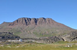
The geography of Canada describes the geographic features of Canada, the world's second largest country in total area.

The Arctic Archipelago, also known as the Canadian Arctic Archipelago, is a group of islands north of the Canadian mainland.
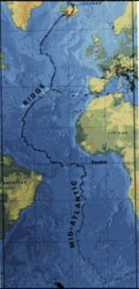
The Mid-Atlantic Ridge (MAR) is a mid-ocean ridge, a divergent tectonic plate or constructive plate boundary located along the floor of the Atlantic Ocean, and part of the longest mountain range in the world. In the North Atlantic it separates the Eurasian and North American plates, and in the South Atlantic it separates the African and South American plates. The ridge extends from a junction with the Gakkel Ridge northeast of Greenland southward to the Bouvet Triple Junction in the South Atlantic. Although the Mid-Atlantic Ridge is mostly an underwater feature, portions of it have enough elevation to extend above sea level. The section of the ridge that includes Iceland is known as the Reykjanes Ridge. The ridge has an average spreading rate of about 2.5 centimetres (0.98 in) per year.

Baffin Bay, located between Baffin Island and the west coast of Greenland, is a marginal sea of the North Atlantic Ocean. It is connected to the Atlantic via Davis Strait and the Labrador Sea. The narrower Nares Strait connects Baffin Bay with the Arctic Ocean. The bay is not navigable most of the year because of the ice cover and high density of floating ice and icebergs in the open areas. However, a polynya of about 80,000 km2 (31,000 sq mi), known as the North Water, opens in summer on the north near Smith Sound. Most of the aquatic life of the bay is concentrated near that region.
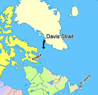
Davis Strait is a northern arm of the Labrador Sea. It lies between mid-western Greenland and Nunavut, Canada's Baffin Island. To the north is Baffin Bay. The strait was named for the English explorer John Davis (1550–1605), who explored the area while seeking a Northwest Passage. By the 1650s it was used for whale hunting.

This is a list of the extreme points of North America: the points that are highest and lowest, and farther north, south, east or west than any other location on the continent. Some of these points are debatable, given the varying definitions of North America.

Kaffeklubben Island or Coffee Club Island is a small island lying off the northern tip of Greenland. It contains the northernmost point of land on Earth.
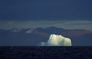
The Greenland Sea is a body of water that borders Greenland to the west, the Svalbard archipelago to the east, Fram Strait and the Arctic Ocean to the north, and the Norwegian Sea and Iceland to the south. The Greenland Sea is often defined as part of the Arctic Ocean, sometimes as part of the Atlantic Ocean. However, definitions of the Arctic Ocean and its seas tend to be imprecise or arbitrary. In general usage the term "Arctic Ocean" would exclude the Greenland Sea. In oceanographic studies the Greenland Sea is considered part of the Nordic Seas, along with the Norwegian Sea. The Nordic Seas are the main connection between the Arctic and Atlantic oceans and, as such, could be of great significance in a possible shutdown of thermohaline circulation. In oceanography the Arctic Ocean and Nordic Seas are often referred to collectively as the "Arctic Mediterranean Sea", a marginal sea of the Atlantic.

Lincoln Sea is a body of water in the Arctic Ocean, stretching from Cape Columbia, Canada, in the west to Cape Morris Jesup, Greenland, in the east. The northern limit is defined as the great circle line between those two headlands. It is covered with sea ice throughout the year, the thickest sea ice in the Arctic Ocean, which can be up to 15 m (49 ft) thick. Water depths range from 100 m (330 ft) to 300 m (980 ft). Water and ice from Lincoln Sea empty into Robeson Channel, the northernmost part of Nares Strait, most of the time.

The Lomonosov Ridge is an unusual underwater ridge of continental crust in the Arctic Ocean. It spans 1,800 kilometres (1,100 mi) between the New Siberian Islands over the central part of the ocean to Ellesmere Island of the Canadian Arctic Archipelago. The ridge divides the Arctic Basin into the Eurasian Basin and the Amerasian Basin. The width of the Lomonosov Ridge varies from 60 to 200 kilometres. It rises 3,300 to 3,700 metres above the 4,200-metre (13,800 ft) deep seabed. The minimum depth of the ocean above the ridge is less than 400 metres (1,300 ft). Slopes of the ridge are relatively steep, broken up by canyons, and covered with layers of silt.
The Sirius Dog Sled Patrol, known informally as Siriuspatruljen and formerly known as North-East Greenland Sledge Patrol and Resolute Dog Sled Patrol, is an elite Danish naval unit. It conducts long-range reconnaissance patrolling, and enforces Danish sovereignty in the Arctic wilderness of northern and eastern Greenland, an area that includes the largest national park in the world. Patrolling is usually done in pairs, sometimes for four months and often without additional human contact.
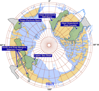
The exploration of the Arctic for petroleum is considered to be extremely technically challenging. However, recent technological developments, as well as relatively high oil prices, have allowed for exploration. As a result, the region has received significant interest from the petroleum industry.
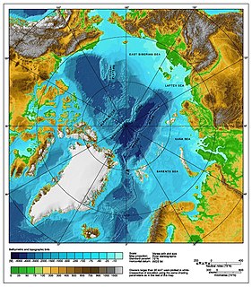
The Arctic consists of land, internal waters, territorial seas, exclusive economic zones (EEZs) and high seas. All land, internal waters, territorial seas and EEZs in the Arctic are under the jurisdiction of one of the eight Arctic coastal states: Canada, Norway, Russia, Denmark, Iceland, Sweden, Finland and the United States. International law regulates this area as with other portions of the Earth.

The Eurasia Basin, or Eurasian Basin, is one of the two major basins into which the Arctic Basin of the Arctic Ocean is split by the Lomonosov Ridge. The Eurasia Basin may be seen as an extension of the North Atlantic Basin through Fram Strait. It is further split by the mid-ocean Gakkel Ridge into the Nansen Basin and the Amundsen Basin. The latter basin is the deepest one of the Arctic Ocean and the geographic North Pole is located there.

The Arctic Ocean is the smallest and shallowest of the world's five major oceans. The International Hydrographic Organization (IHO) recognizes it as an ocean, although some oceanographers call it the Arctic Mediterranean Sea or simply the Arctic Sea, classifying it a mediterranean sea or an estuary of the Atlantic Ocean. It is also seen as the northernmost part of the all-encompassing World Ocean.

Akuliarusiarsuup Kuua is a river and valley of the same name in the Qeqqata municipality in central-western Greenland. Its source is the meltwater outflow from Russell Glacier, an outflow of the Greenland ice sheet. The river is a tributary of Qinnguata Kuussua, the main river in the Kangerlussuaq area. For most of its run, the river flows very slowly through the sandur basin of the valley, forming meanders amongst large fields of glacial silt quicksand. The climate is polar continental, with the area receiving very little rainfall.
The Greenland Plate is a supposed tectonic plate bounded to the west by Nares Strait, a probable transform fault, on the southwest by the Ungava transform underlying Davis Strait, on the southeast by the Mid-Atlantic Ridge, and the northeast by the Gakkel Ridge, with its northwest border is still being explored. The Greenland craton is made up of some of the oldest rocks on Earth. The Isua greenstone belt in southwestern Greenland contains the oldest known rocks on Earth dated at 3.7–3.8 billion years old.
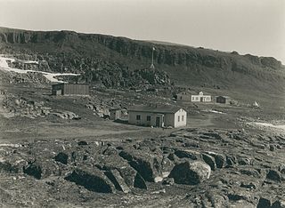
University of Copenhagen Arctic Station is a year-round, environmental research facility in central West Greenland. Located about 300 metres (980 ft) northeast of Qeqertarsuaq, it faces Disko Bay and the Davis Strait on the south coast of Disko Island with the Blæsedalen valley to the north. The main building and the laboratory are within a nature sanctuary. Arctic Station is owned by the University of Copenhagen Faculty of Science. It was founded in 1906 by the botanist Morten Pedersen Porsild.

The Princess Caroline-Mathilde Alps are a mountain range system in the Holm Land Peninsula, King Frederick VIII Land, northeastern Greenland. Administratively this range is part of the Northeast Greenland National Park zone.


