Centennial Park is a suburb split between the local government area of the City of Sydney and the City of Randwick, in the eastern suburbs of Sydney, New South Wales, Australia. Centennial Park is located 4 kilometres (2.5 mi) south-east of the Sydney central business district, in the eastern suburbs of Sydney in the state of New South Wales, Australia.

Claisebrook railway station is a Transperth railway station 1300 metres from Perth, in Western Australia, on the Armadale/Thornlie and Midland lines.

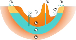
Bedok Reservoir is a reservoir in the eastern part of Singapore, to the north of Bedok New Town. The reservoir has a surface area of 880,000 m², and a capacity of 12.8 million m³. The mean depth of the reservoir is 9 m, with a maximum depth of 18.2 m. The shoreline length is 4.3 km.

Mount Eliza is a hill that overlooks the city of Perth, Western Australia and forms part of Kings Park. It is known as Kaarta gar-up and Mooro Katta in the local Noongar dialect.

Bold Park is a 437-hectare (1,080-acre) urban bushland area in the suburb of City Beach, in Perth, Western Australia. It is located 8 km (5 mi) directly west of the Perth central business district, its western border less than one kilometre from the Indian Ocean. To the east, Perry Lakes reserve is directly adjacent to the park. The hilly topography allows views of both the city and ocean.
Buckland Hill Reservoir is situated in Mosman Park, Western Australia. The covered reservoir is the most westerly in the Perth metropolitan area and provides sweeping views across Gage Roads of Rottnest Island, Garden Island and the Port of Fremantle and mouth of the Swan River to the west and Lucky Bay and Bicton and East Fremantle to the east. The reservoir was originally filled with water from Perth's hill dams and features a water treatment plant. Most of Perth's water supply is now sourced from groundwater aquifers in the Swan Valley. Buckland Hill supplies water to the area from Fremantle and Claremont.

The Collie River is a river in the South West region of Western Australia.
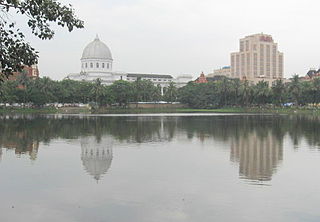
Lal Dighi is a body of water in the middle of B. B. D. Bagh, earlier known as Tank Square or Dalhousie Square, in the heart of Kolkata, earlier known as Calcutta, in the Indian state of West Bengal.

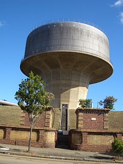
The High Service Water Tower and Reservoir, colloquially known as the Tower Hill Tower, is a public water supply facility off Massachusetts Route 110 in Lawrence, Massachusetts. The reservoir was constructed in 1874-75 to provide the city's public water supply, with a gatehouse designed by Charles T. Emerson, a Lawrence architect. The tower was built in 1896 as a high pressure standpipe or water tower. The tower stands 157 feet (48 m) high, and is built out of red brick with granite trim. It is Romanesque in its style, and was designed by George G. Adams, a noted local architect who had been taught by Emerson. The standpipe inside the tower is of steel construction and is 102 feet (31 m) in height. The area above the standpipe includes a balcony capped by a chateauesque roof, with round-arch windows providing views of the area. The main tower is octagonal in shape, with a narrow round staircase tower projection from one side.

Birket Israel also Birket Israil or Birket Isra'in, abbreviated from Birket Beni Israìl was a public cistern located on the north-eastern corner of the Temple Mount, in Jerusalem. The structure is believed to have been built by the Romans for use as a water reservoir and also to protect the northern wall of the Temple Mount. Arab locals have known it by this name since at least 1857.

Walka Water Works is a heritage-listed 19th-century pumping station at 55 Scobies Lane, Oakhampton Heights, City of Maitland, New South Wales, Australia. Originally built in 1887 to supply water to Newcastle and the lower Hunter Valley, it has since been restored and preserved and is part of Maitland City Council's Walka Recreation and Wildlife Reserve. It was added to the New South Wales State Heritage Register on 2 April 1999.

Robe River is a river in the Pilbara region of Western Australia.

Reservoir Park is a historic park on Boylston Street in Brookline, Massachusetts. Its principal feature is Brookline Reservoir, formerly an element of the public water supply for neighboring Boston. The reservoir was built in 1848 as the main terminus of the now-defunct Cochituate Aqueduct, which delivered water from Lake Cochituate in the western suburbs. The reservoir covers 21.1 acres (8.5 ha), and is roughly kidney-shaped. A gravel path extends around the perimeter of the reservoir. The park is bounded on the north by Boylston Street, on the west by Lee Street, on the south by Dudley Street, and on the east by Warren and Walnut Streets.

The Paddington Reservoir is a heritage-listed public park located at 255a Oxford Street in the inner eastern Sydney suburb of Paddington in the City of Sydney local government area of New South Wales, Australia. It was designed by Edward Bell and built from 1864 to 1866 and operated as a water reservoir which accepted water from the Botany Swamps pumping station for supply to parts of Sydney between 1866 and 1899. In the twentieth century the site variously functioned as a service station and storage and mechanical workshop site. In 2006 it was converted into a sunken garden and park. It is also known as Walter Read Reserve; Paddington Reservoir Gardens; Reservoir Gardens. The property is owned by City of Sydney. It was added to the New South Wales State Heritage Register on 2 April 1999.

Llys y Fran is a small village and parish in the community of New Moat on the southern slopes of the Preseli Mountains in Pembrokeshire, Wales. The parish includes the small settlement of Gwastad. A notable feature is Llys y Fran Reservoir and Country Park, a popular tourist attraction.
Petersham Reservoir is a heritage-listed water reservoir at New Canterbury Road, Petersham, Inner West Council, Sydney New South Wales, Australia. It was designed and built by the New South Wales Public Works Department. It is also known as Petersham Service Reservoir and WS089. The property is owned by Sydney Water. It was added to the New South Wales State Heritage Register on 18 November 1999.

Bankstown Reservoir is a heritage-protected water tower and a local landmark situated in the suburb of Bankstown, Sydney, New South Wales, Australia. Located 22 kilometres (14 mi) west of Sydney CBD, the reservoir is elevated and was built on reinforced concrete piers, which is one of the oldest of this type that is still in use. The reservoir features various decorative attributes, plastered by hand, which lack in other functional reservoirs. Established in 1920, the reservoir serves a large area of South-Western Sydney.

Potts Hill Reservoirs 1 and 2 are heritage-listed reservoirs at Cooper Road, Potts Hill, Canterbury-Bankstown Council, New South Wales, Australia. It was designed by Board of Water Supply and Sewerage & Sydney Water and built from 1880. The property is owned by Sydney Water. It was added to the New South Wales State Heritage Register on 18 November 1999.

Prospect Nature Reserve is a nature reserve and recreational area that is situated in the western suburbs of Sydney, New South Wales, Australia, which incorporates the Prospect Reservoir, and also features picnic spots, lookouts, walking tracks and BBQ areas within the Australian bush. It is located within the Blacktown City local government area, but is also close to the boundaries of Cumberland Council and the City of Fairfield.