
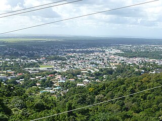
San Fernando, officially the City of San Fernando, is the most populous city and second most populous municipality in Trinidad and Tobago, after Chaguanas. Sando, as it is known to many local Trinidadians, occupies 19 km2 and is located in the southwestern part of the island of Trinidad. It is bounded to the north by the Guaracara River, the south by the Oropouche River, the east by the Sir Solomon Hochoy Highway, and the west by the Gulf of Paria. The former borough was elevated to the status of a city corporation on 18 November 1988. The motto of San Fernando is: "Sanitas Fortis" - In a Healthy Environment We Will Find Strength. San Fernando is called Trinidad and Tobago's "industrial capital" because of its proximity to the Pointe-à-Pierre oil refinery and many other petrochemical, LNG, iron and steel and aluminium smelters in places such as Point Lisas in Couva, Point Fortin, and La Brea.

Mayaro is the name of a county on southeastern Trinidad island, in Trinidad and Tobago.

La Brea is a town in southwestern Trinidad, located northeast of Point Fortin and southwest of San Fernando. La Brea is best known as the site of the Pitch Lake, a natural asphalt lake. Pronunciation of "La Brea" differs from that used in the USA at the La Brea Tar Pits in Los Angeles. Trinidadians call this place "La Bray".

San Juan is a town in Trinidad and Tobago. Located in San Juan–Laventille region in Saint George County, it lies within the East-West Corridor Metropolitan Area, between Laventille and Saint Joseph.

Sangre Grande is the largest town in northeastern Trinidad and Tobago. It is located east of Arima and southwest of the village of Toco. It is the seat of the Sangre Grande Regional Corporation and capital of the region.
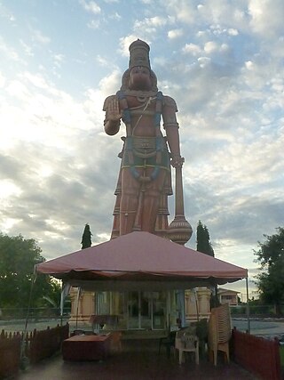
Penal is a town in south Trinidad, Trinidad and Tobago. It lies south of San Fernando, Princes Town, and Debe, and north of Moruga, Morne Diablo and Siparia. Penal is noted as a heartland of Hindu and Indo-Trinidadian culture.
Saint Augustine is a town in the northwest of Trinidad, Trinidad and Tobago.

Diego Martin is a town and is the urban commercial center and capital of the Diego Martin region in Trinidad and Tobago. Its location in the region is just on the south eastern border, west of the capital city of Port of Spain and east of the town of Carenage. Diego Martin town in the Northern Range was once filled with a number of small valleys but is now a densely populated area. It was named after a Spanish explorer Don Diego Martín. The area was settled by French planters and their slaves in the 1780s. It consists of a cluster of communities including Congo Village, Diamond Vale, Green Hill, Patna Village, Petit Valley, Blue Range, La Puerta Avenue, Four Roads, Rich Plain, River Estate, Blue Basin, Water Wheel, West Moorings, Bagatelle and Sierra Leone.
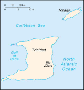
Rio Claro is the largest town in southeastern Trinidad, in Trinidad and Tobago. Rio Claro lies east of Princes Town, west of Mayaro and northwest of Guayaguayare. It serves as the major commercial centre for southeastern Trinidad. It lies in a primarily agricultural area. It is the seat of the Region of Mayaro–Rio Claro.

Blanchisseuse is a village in Trinidad and Tobago. It is located about midway along the north coast of Trinidad on the northern slope of the Northern Range, about 24 km north of Arima.
Cedros is a coastal area that lies on a peninsula at the South-Western end of the island of Trinidad. Named by Spanish sailors due to the once heavy presence of cedar trees, it is located at the tip of the peninsula which lies mere miles off the coast of Venezuela and is the most southern point in the Caribbean. The main area is known as Bonasse which is of French origin meaning "easy-going."
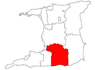
Princes Town is a region of Trinidad and Tobago. The local government body is Princes Town Regional Corporation, a Regional Corporation of Trinidad and Tobago. The region has a land area of 620 km2. The Princes Town Regional Corporation is headquartered in Princes Town.
The Navet Dam is one of the major reservoirs supplying potable water in Trinidad and Tobago. It is located in Tabaquite, Trinidad and Tobago and is managed by the Water and Sewerage Authority of Trinidad and Tobago. The dam was completed in 1962, expanded in 1966 and 1976. It supplies Rio Claro, Tableland, Biche, Princes Town, Williams Ville, Borde Narve.
Carapichaima is a town in central Trinidad, Trinidad and Tobago. Communities and villages in Carapichaima include Orangefield, Waterloo, Brickfield, and Korea Village.
The Public Transport Service Corporation or better known as PTSC is the state-owned public transport provider for Trinidad and Tobago. Its headquarters are at City Gate in Port of Spain. Passengers have to buy the tickets at a ticket booth and show it to the driver. The fares vary with distance. There are two type of buses: the blue-and-white buses are the regular and the red-and-white are the express commuter buses. The latter are more expensive, make fewer stops and are more comfortable.
Iere Village is a small village in southern Trinidad, north west of Princes Town. Though small in size, the village is rich in history. It is the site of the first Presbyterian church, the first Islamic mosque and the first government funded school in Trinidad. The village is located on the Naparima Mayaro Road just outside Princes Town. The village's primary school, Iere Government Primary, has been rebuilt and located further up the road from its original location on Richmond.

Macoya is a small town located alongside the Churchill-Roosevelt Highway in Trinidad and Tobago. It is located between Tunapuna and Trincity on the island of Trinidad.
Cowen Hamilton Secondary School is a school in south Trinidad. Pronounced "Co-win", the school was founded on 16 January 1962 to provide education in the fifth company village, located near Princes Town and Moruga, Trinidad.
The South Trunk Road is a major arterial road on the island of Trinidad, in Trinidad and Tobago. It runs for 13.5 km.
The San Fernando By-Pass is a major bypass road on the island of Trinidad, in Trinidad and Tobago. It runs for 4.9 kilometres (3.0 mi).