The Cascade Range or Cascades is a major mountain range of western North America, extending from southern British Columbia through Washington and Oregon to Northern California. It includes both non-volcanic mountains, such as the North Cascades, and the notable volcanoes known as the High Cascades. The small part of the range in British Columbia is referred to as the Canadian Cascades or, locally, as the Cascade Mountains. The latter term is also sometimes used by Washington residents to refer to the Washington section of the Cascades in addition to North Cascades, the more usual U.S. term, as in North Cascades National Park. The highest peak in the range is Mount Rainier in Washington at 14,411 feet (4,392 m).

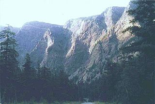
Mount Garibaldi is a potentially active stratovolcano in the Sea to Sky Country of British Columbia, 80 km (50 mi) north of Vancouver, British Columbia, Canada. Located in the southernmost Coast Mountains, it is one of the most recognized peaks in the South Coast region, as well as British Columbia's best known volcano. It lies within the Garibaldi Ranges of the Pacific Ranges.

The Peace River is a 1,923-kilometre-long (1,195 mi) river in Canada that originates in the Rocky Mountains of northern British Columbia and flows to the northeast through northern Alberta. The Peace River joins the Athabasca River in the Peace-Athabasca Delta to form the Slave River, a tributary of the Mackenzie River. The Finlay River, the main headwater of the Peace River, is regarded as the ultimate source of the Mackenzie River. The combined Finlay–Peace–Slave–Mackenzie river system is the 13th longest river system in the world.

Shuswap Lake is a lake located in south-central British Columbia, Canada that drains via the Little River into Little Shuswap Lake. Little Shuswap Lake is the source of the South Thompson River, a branch of the Thompson River, a tributary of the Fraser River. It is at the heart of a region known as the Shuswap Country or "the Shuswap", noted for its recreational lakeshore communities including the city of Salmon Arm. The name "Shuswap" is derived from the Shuswap or Secwepemc First Nations people, the most northern of the Interior Salish peoples, whose territory includes the Shuswap. The Shuswap call themselves /ʃǝxwépmǝx/ in their own language, which is called /ʃǝxwepmǝxtʃín/, but the ethnonym’s original meaning is now lost.

The Cheakamus River is a tributary of the Squamish River, beginning on the west slopes of Outlier Peak in Garibaldi Provincial Park upstream from Cheakamus Lake on the southeastern outskirts of the resort area of Whistler. The river flows into Cheakamus Lake before exiting it and flowing northwest until it turns south and enters Daisy Lake. Between the outlet of Daisy Lake and its mouth, much of its length is spent going through Cheakamus Canyon, where the river flows through swift rapids and even one good sized waterfall. The river flows south from the lake and through the canyon before joining the Squamish River at Cheekye, a few miles north of the town of Squamish. The river's name is an anglicization of the name of Chiyakmesh, a village of the Squamish people and a reserve of the Squamish Nation.
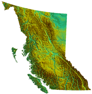
British Columbia is the westernmost province of Canada, bordered by the Pacific Ocean. With an area of 944,735 square kilometres (364,764 sq mi) it is Canada's third-largest province. The province is almost four times the size of United Kingdom, two and one-half times larger than Japan and larger than every U.S. state except Alaska. It is bounded on the northwest by the U.S. state of Alaska, directly north by Yukon and the Northwest Territories, on the east by Alberta, and on the south by the U.S. states of Washington, Idaho, and Montana. Formerly part of the British Empire, the southern border of British Columbia was established by the 1846 Oregon Treaty. The province is dominated by mountain ranges, among them the Canadian Rockies but dominantly the Coast Mountains, Cassiar Mountains, and the Columbia Mountains. Most of the population is concentrated on the Pacific coast, notably in the area of Vancouver, located on the southwestern tip of the mainland, which is known as the Lower Mainland. It is the most mountainous province of Canada.
The Pacific Ranges are the southernmost subdivision of the Coast Mountains portion of the Pacific Cordillera. Located entirely within British Columbia, Canada, they run northwest from the lower stretches of the Fraser River to Bella Coola and Burke Channel, north of which are the Kitimat Ranges. The Coast Mountains lie between the Interior Plateau and the Coast of British Columbia.
Driftwood Canyon Provincial Park is a provincial park in British Columbia, Canada. Driftwood Canyon Provincial Park covers 23 ha of the Bulkley River Valley, on the east side of Driftwood Creek, a tributary of the Bulkley River, 10 km northeast of the town of Smithers. The park is accessible from Driftwood Road from Provincial Highway 16. It was created in 1967 by the donation of the land by the late Gordon Harvey (1913–1976) to protect fossil beds on the east side of Driftwood Creek. The beds were discovered around the beginning of the 20th century. The park lands are part of the asserted traditional territory of the Wet'suwet'en First Nation.

Iskut River Hot Springs Provincial Park is a 4-hectare (9.9-acre) provincial park in British Columbia, Canada, located on the western side of the Iskut River.

The Mount Meager massif is a group of volcanic peaks in the Pacific Ranges of the Coast Mountains in southwestern British Columbia, Canada. Part of the Cascade Volcanic Arc of western North America, it is located 150 km (93 mi) north of Vancouver at the northern end of the Pemberton Valley and reaches a maximum elevation of 2,680 m (8,790 ft). The massif is capped by several eroded volcanic edifices, including lava domes, volcanic plugs and overlapping piles of lava flows; these form at least six major summits including Mount Meager which is the second highest of the massif.

Mount Price is a small stratovolcano in the Garibaldi Ranges of the Pacific Ranges in southwestern British Columbia, Canada. It is located 10 km (6.2 mi) southeast of the abandoned settlement of Garibaldi above the eastern flank of the Cheakamus River valley. With a summit elevation of 2,052 m (6,732 ft) and a topographic prominence of 402 m (1,319 ft), it rises above the surrounding landscape on the western shore of Garibaldi Lake. A large provincial park surrounds Mount Price and other volcanoes in its vicinity.

Ash Mountain is the highest summit in the Tuya Range of the Stikine Ranges in northcentral British Columbia, Canada, located immediately north of High Tuya Lake at the north end of Tuya Mountains Provincial Park. It is one of the six tuyas clustered close to Tuya Lake. The base of the volcano comprises pillow lava and hyaloclastite indicating that the volcano formed beneath ice or under a large lake. The volcano comprises loose debris as well as dikes of basaltic rock that intruded into the volcanic pile. Other tuyas in the area include Tuya Butte, South Tuya and Mathews Tuya, although most of the group of tuyas are unnamed.

The Tuya Range is a rmountain range in the Stikine Ranges of the Cassiar Mountains in the far north of the Canadian province of British Columbia, near its border with the Yukon Territory and to the southwest of Watson Lake, Yukon, which is the nearest major settlement.

Volcanology of Canada includes lava flows, lava plateaus, lava domes, cinder cones, stratovolcanoes, shield volcanoes, submarine volcanoes, calderas, diatremes, and maars, along with examples of more less common volcanic forms such as tuyas and subglacial mounds. It has a very complex volcanological history spanning from the Precambrian eon at least 3.11 billion years ago when this part of the North American continent began to form.
Mount Downton is the highest summit of the 10 km (6 mi) diameter Itcha Range, located 40 km (25 mi) northeast of Anahim Lake and 33 km (21 mi) east of Far Mountain in the Chilcotin District of the Central Interior of British Columbia, Canada. It lies within Itcha Ilgachuz Provincial Park.

The Stikine Country, also referred to as the Stikine District or simply "the Stikine", is one of the historical geographic regions of the Canadian province of British Columbia, located inland from the central Alaska Panhandle and comprising the basin of the Stikine River and its tributaries. The term Stikine–Iskut is also fairly common to describe the area, and references the Iskut River, the Stikine's largest tributary and describable as its south fork.
Griswold Pass is a mountain pass in the Pacific Ranges of the Coast Mountains of British Columbia, located at the head of Nichols Creek, a tributary of the upper Bridge River (S), and the head of Griswold Creek, a tributary of the Lord River (N), which feeds the Taseko Lakes and is effectively a tributary of the Taseko River. The Nichols Creek area is part of the volcanic formation known as the Bridge River Cones, while to the north of the pass the Taseko Lakes basin is part of Tsy'los Provincial Park.

The Volcano, also known as Lava Fork volcano, is a small cinder cone in the Boundary Ranges of the Coast Mountains in northwestern British Columbia, Canada. It is located approximately 60 km (40 mi) northwest of the small community of Stewart near the head of Lava Fork. With a summit elevation of 1,656 m (5,433 ft) and a topographic prominence of 311 m (1,020 ft), it rises above the surrounding rugged landscape on a remote mountain ridge that represents the northern flank of a glaciated U-shaped valley.
The Bridge River Vent is a volcanic crater in the Pacific Ranges of the Coast Mountains in southwestern British Columbia, Canada. It is located 51 km (32 mi) west of Bralorne on the northeastern flank of the Mount Meager massif. With an elevation of 1,524 m (5,000 ft), it lies on the steep northern face of Plinth Peak, a 2,677 m (8,783 ft) high volcanic peak comprising the northern portion of Meager. The vent rises above the western shoulder of the Pemberton Valley and represents the northernmost volcanic feature of the Mount Meager massif.