
The Nile is a major north-flowing river in northeastern Africa. It flows into the Mediterranean Sea. The Nile is the longest river in Africa and has historically been considered the longest river in the world, though this has been contested by research suggesting that the Amazon River is slightly longer. Of the world's major rivers, the Nile is one of the smallest, as measured by annual flow in cubic metres of water. About 6,650 km (4,130 mi) long, its drainage basin covers eleven countries: the Democratic Republic of the Congo, Tanzania, Burundi, Rwanda, Uganda, Kenya, Ethiopia, Eritrea, South Sudan, Sudan, and Egypt. In particular, the Nile is the primary water source of Egypt, Sudan and South Sudan. Additionally, the Nile is an important economic river, supporting agriculture and fishing.

The Tethys OceanTEETH-iss, TETH-, also called the Tethys Sea or the Neo-Tethys, was a prehistoric ocean during much of the Mesozoic Era and early Cenozoic Era, located between the ancient continents of Gondwana and Laurasia, before the opening of the Indian and Atlantic oceans during the Cretaceous Period.

The Coast Mountains are a major mountain range in the Pacific Coast Ranges of western North America, extending from southwestern Yukon through the Alaska Panhandle and virtually all of the Coast of British Columbia south to the Fraser River. The mountain range's name derives from its proximity to the sea coast, and it is often referred to as the Coast Range. The range includes volcanic and non-volcanic mountains and the extensive ice fields of the Pacific and Boundary Ranges, and the northern end of the volcanic system known as the Cascade Volcanoes. The Coast Mountains are part of a larger mountain system called the Pacific Coast Ranges or the Pacific Mountain System, which includes the Cascade Range, the Insular Mountains, the Olympic Mountains, the Oregon Coast Range, the California Coast Ranges, the Saint Elias Mountains and the Chugach Mountains. The Coast Mountains are also part of the American Cordillera—a Spanish term for an extensive chain of mountain ranges—that consists of an almost continuous sequence of mountain ranges that form the western backbone of North America, Central America, South America and Antarctica.

The Pacific Coast Ranges are the series of mountain ranges that stretch along the West Coast of North America from Alaska south to Northern and Central Mexico. Although they are commonly thought to be the westernmost mountain range of the continental United States and Canada, the geologically distinct Insular Mountains of Vancouver Island lie farther west.
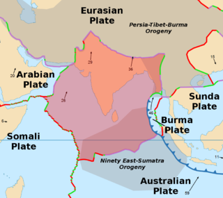
The Indian Plate is a minor tectonic plate straddling the equator in the Eastern Hemisphere. Originally a part of the ancient continent of Gondwana, the Indian Plate broke away from the other fragments of Gondwana 100 million years ago, began moving north and carried Insular India with it. It was once fused with the adjacent Australian Plate to form a single Indo-Australian Plate, and recent studies suggest that India and Australia have been separate plates for at least 3 million years and likely longer. The Indian Plate includes most of modern South Asia and a portion of the basin under the Indian Ocean, including parts of South China and western Indonesia, and extending up to but not including Ladakh, Kohistan and Balochistan.

The Mascarene Plateau is a submarine plateau in the Indian Ocean, north and east of Madagascar. The plateau extends approximately 2,000 km (1,200 mi), from Seychelles in the north to Réunion in the south. The plateau covers an area of over 115,000 km2 (44,000 sq mi) of shallow water, with depths ranging from 8–150 m (30–490 ft), plunging to 4,000 m (13,000 ft) to the abyssal plain at its edges.
The Intermontane Plate was an ancient oceanic tectonic plate that lay on the west coast of North America about 195 million years ago. The Intermontane Plate was surrounded by a chain of volcanic islands called the Intermontane Islands, which had been accumulating as a volcanic chain in the Pacific Ocean since the Triassic period, beginning around 245 million years ago. The volcanism records yet another subduction zone. Beneath the far edge of the Intermontane microplate, another plate called the Insular Plate was sinking. This arrangement with two parallel subduction zones is unusual. The modern Philippine Islands are located on the Philippine Mobile Belt, one of the few places on Earth where twin subduction zones exist today. Geologists call the ocean between the Intermontane islands and North America the Slide Mountain Ocean. The name comes from the Slide Mountain Terrane, a region made of rocks from the floor of the ancient ocean.

The Intermontane Islands were a giant chain of active volcanic islands somewhere in the Pacific Ocean during the Triassic time beginning around 245 million years ago. They were 600 to 800 miles (1,300 km) long and rode atop a microplate known as the Intermontane Plate. Over early Jurassic time the Intermontane Islands and the Pacific Northwest drew closer together as the continent moved west and the Intermontane Plate subducted. About 180 million years ago in the Mid-Jurassic time the last of the Intermontane Plate subducted and the Intermontane Islands collided with the Pacific Northwest, forming parts of British Columbia, Canada. The Intermontane Islands were too big to sink beneath the continent, and welded onto the continent, forming the Intermontane Belt. Geologists call the ocean that existed between the Intermontane Islands and North America the Slide Mountain Ocean.
The Slide Mountain Ocean was an ancient ocean that existed between the Intermontane Islands and North America beginning around 245 million years ago in the Triassic period. It is named after the Slide Mountain Terrane, which is composed of rocks from the ancient oceanic floor. There was a subduction zone on the Slide Mountain Ocean's floor called the Intermontane Trench where the Intermontane Plate was being subducted under North America. The floor of the Slide Mountain Ocean was pushed up onto the ancient margin of North America.
The Kula-Farallon Ridge was an ancient mid-ocean ridge that existed between the Kula and Farallon plates in the Pacific Ocean during the Jurassic period. There was a small piece of this ridge off the Pacific Northwest 43 million years ago. The rest of the ridge has since been subducted beneath Alaska.

The Insular Islands were an extended chain of volcanic islands forming an arc in what is now the Pacific Ocean during the Paleozoic and Mesozoic eras. The islands formed by subduction and melting of the Farallon Plate along a fragment upon which they rose called the Insular Plate. They were bounded by the Panthalassic Ocean to the west and the Bridge River Ocean to the east. They probably formed as a composite of several volcanic chains near the equator, offshore of continental landmasses, by the Carboniferous Period around 300-325 million years ago.

The Intermontane Belt is a physiogeological region in the Pacific Northwest of North America, stretching from northern Washington into British Columbia, Yukon, and Alaska. It comprises rolling hills, high plateaus and deeply cut valleys. The rocks in the belt have very little similarities with the North American continent.

Volcanic activity is a major part of the geology of Canada and is characterized by many types of volcanic landform, including lava flows, volcanic plateaus, lava domes, cinder cones, stratovolcanoes, shield volcanoes, submarine volcanoes, calderas, diatremes, and maars, along with less common volcanic forms such as tuyas and subglacial mounds.

The geology of the Pacific Northwest includes the composition, structure, physical properties and the processes that shape the Pacific Northwest region of North America. The region is part of the Ring of Fire: the subduction of the Pacific and Farallon Plates under the North American Plate is responsible for many of the area's scenic features as well as some of its hazards, such as volcanoes, earthquakes, and landslides.

The geological history of the Earth follows the major geological events in Earth's past based on the geological time scale, a system of chronological measurement based on the study of the planet's rock layers (stratigraphy). Earth formed about 4.54 billion years ago by accretion from the solar nebula, a disk-shaped mass of dust and gas left over from the formation of the Sun, which also created the rest of the Solar System.
The Insular Belt is a physiogeological region on the north western North American coast. It consists of three major island groups and many smaller islands and stretches from southern British Columbia into Alaska and the Yukon. It represents the Late Cretaceous to Eocene accretion of what is known as the Insular Superterrane to the North American continent.
The geology of British Columbia is a function of its location on the leading edge of the North American continent. The mountainous physiography and the diversity of the different types and ages of rock hint at the complex geology, which is still undergoing revision despite a century of exploration and mapping.

The Coast Range Arc was a large volcanic arc system, extending from northern Washington through British Columbia and the Alaska Panhandle to southwestern Yukon. The Coast Range Arc lies along the western margin of the North American Plate in the Pacific Northwest of western North America. Although taking its name from the Coast Mountains, this term is a geologic grouping rather than a geographic one, and the Coast Range Arc extended south into the High Cascades of the Cascade Range, past the Fraser River which is the northward limit of the Cascade Range proper.
This is a list of articles related to plate tectonics and tectonic plates.
