
The Coast Mountains are a major mountain range in the Pacific Coast Ranges of western North America, extending from southwestern Yukon through the Alaska Panhandle and virtually all of the Coast of British Columbia south to the Fraser River. The mountain range's name derives from its proximity to the sea coast, and it is often referred to as the Coast Range. The range includes volcanic and non-volcanic mountains and the extensive ice fields of the Pacific and Boundary Ranges, and the northern end of the volcanic system known as the Cascade Volcanoes. The Coast Mountains are part of a larger mountain system called the Pacific Coast Ranges or the Pacific Mountain System, which includes the Cascade Range, the Insular Mountains, the Olympic Mountains, the Oregon Coast Range, the California Coast Ranges, the Saint Elias Mountains and the Chugach Mountains. The Coast Mountains are also part of the American Cordillera—a Spanish term for an extensive chain of mountain ranges—that consists of an almost continuous sequence of mountain ranges that form the western backbone of North America, Central America, South America and Antarctica.

The Ring of Fire is a region around much of the rim of the Pacific Ocean where many volcanic eruptions and earthquakes occur. The Ring of Fire is a horseshoe-shaped belt about 40,000 km (25,000 mi) long and up to about 500 km (310 mi) wide.

The Laramide orogeny was a time period of mountain building in western North America, which started in the Late Cretaceous, 70 to 80 million years ago, and ended 35 to 55 million years ago. The exact duration and ages of beginning and end of the orogeny are in dispute. The Laramide orogeny occurred in a series of pulses, with quiescent phases intervening. The major feature that was created by this orogeny was deep-seated, thick-skinned deformation, with evidence of this orogeny found from Canada to northern Mexico, with the easternmost extent of the mountain-building represented by the Black Hills of South Dakota. The phenomenon is named for the Laramie Mountains of eastern Wyoming. The Laramide orogeny is sometimes confused with the Sevier orogeny, which partially overlapped in time and space.

The Farallon Plate was an ancient oceanic plate. It formed one of the three main plates of Panthalassa, alongside the Phoenix Plate and Izanagi Plate, which were connected by a triple junction. The Farallon Plate began subducting under the west coast of the North American Plate—then located in modern Utah—as Pangaea broke apart and after the formation of the Pacific Plate at the centre of the triple junction during the Early Jurassic. It is named for the Farallon Islands, which are located just west of San Francisco, California.
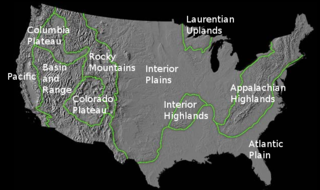
The richly textured landscape of the United States is a product of the dueling forces of plate tectonics, weathering and erosion. Over the 4.5 billion-year history of the Earth, tectonic upheavals and colliding plates have raised great mountain ranges while the forces of erosion and weathering worked to tear them down. Even after many millions of years, records of Earth's great upheavals remain imprinted as textural variations and surface patterns that define distinctive landscapes or provinces.

A volcanic arc is a belt of volcanoes formed above a subducting oceanic tectonic plate, with the belt arranged in an arc shape as seen from above. Volcanic arcs typically parallel an oceanic trench, with the arc located further from the subducting plate than the trench. The oceanic plate is saturated with water, mostly in the form of hydrous minerals such as micas, amphiboles, and serpentine minerals. As the oceanic plate is subducted, it is subjected to increasing pressure and temperature with increasing depth. The heat and pressure break down the hydrous minerals in the plate, releasing water into the overlying mantle. Volatiles such as water drastically lower the melting point of the mantle, causing some of the mantle to melt and form magma at depth under the overriding plate. The magma ascends to form an arc of volcanoes parallel to the subduction zone.

The Pacific Ranges are the southernmost subdivision of the Coast Mountains portion of the Pacific Cordillera. Located entirely within British Columbia, Canada, they run northwest from the lower stretches of the Fraser River to Bella Coola and Burke Channel, north of which are the Kitimat Ranges. The Coast Mountains lie between the Interior Plateau and the Coast of British Columbia.
The Intermontane Plate was an ancient oceanic tectonic plate that lay on the west coast of North America about 195 million years ago. The Intermontane Plate was surrounded by a chain of volcanic islands called the Intermontane Islands, which had been accumulating as a volcanic chain in the Pacific Ocean since the Triassic period, beginning around 245 million years ago. The volcanism records yet another subduction zone. Beneath the far edge of the Intermontane microplate, another plate called the Insular Plate was sinking. This arrangement with two parallel subduction zones is unusual. The modern Philippine Islands are located on the Philippine Mobile Belt, one of the few places on Earth where twin subduction zones exist today. Geologists call the ocean between the Intermontane islands and North America the Slide Mountain Ocean. The name comes from the Slide Mountain Terrane, a region made of rocks from the floor of the ancient ocean.

The geology of the Rocky Mountains is that of a discontinuous series of mountain ranges with distinct geological origins. Collectively these make up the Rocky Mountains, a mountain system that stretches from Northern British Columbia through central New Mexico and which is part of the great mountain system known as the North American Cordillera.

The Intermontane Belt is a physiogeological region in the Pacific Northwest of North America, stretching from northern Washington into British Columbia, Yukon, and Alaska. It comprises rolling hills, high plateaus and deeply cut valleys. The rocks in the belt have very little similarities with the North American continent.

Volcanic activity is a major part of the geology of Canada and is characterized by many types of volcanic landform, including lava flows, volcanic plateaus, lava domes, cinder cones, stratovolcanoes, shield volcanoes, submarine volcanoes, calderas, diatremes, and maars, along with less common volcanic forms such as tuyas and subglacial mounds.

The geology of the Pacific Northwest includes the composition, structure, physical properties and the processes that shape the Pacific Northwest region of North America. The region is part of the Ring of Fire: the subduction of the Pacific and Farallon Plates under the North American Plate is responsible for many of the area's scenic features as well as some of its hazards, such as volcanoes, earthquakes, and landslides.

This is a brief summary of the geology of Indonesia. Indonesia is located between two major tectonic plates, the Australian Plate and the Eurasian Plate.
The geology of British Columbia is a function of its location on the leading edge of the North American continent. The mountainous physiography and the diversity of the different types and ages of rock hint at the complex geology, which is still undergoing revision despite a century of exploration and mapping.

The Coast Range Arc was a large volcanic arc system, extending from northern Washington through British Columbia and the Alaska Panhandle to southwestern Yukon. The Coast Range Arc lies along the western margin of the North American Plate in the Pacific Northwest of western North America. Although taking its name from the Coast Mountains, this term is a geologic grouping rather than a geographic one, and the Coast Range Arc extended south into the High Cascades of the Cascade Range, past the Fraser River which is the northward limit of the Cascade Range proper.
This is a list of articles related to plate tectonics and tectonic plates.

The Canadian Cascade Arc, also called the Canadian Cascades, is the Canadian segment of the North American Cascade Volcanic Arc. Located entirely within the Canadian province of British Columbia, it extends from the Cascade Mountains in the south to the Coast Mountains in the north. Specifically, the southern end of the Canadian Cascades begin at the Canada–United States border. However, the specific boundaries of the northern end are not precisely known and the geology in this part of the volcanic arc is poorly understood. It is widely accepted by geologists that the Canadian Cascade Arc extends through the Pacific Ranges of the Coast Mountains. However, others have expressed concern that the volcanic arc possibly extends further north into the Kitimat Ranges, another subdivision of the Coast Mountains, and even as far north as Haida Gwaii.

The geology of North America is a subject of regional geology and covers the North American continent, the third-largest in the world. Geologic units and processes are investigated on a large scale to reach a synthesized picture of the geological development of the continent.

The Pacific Ocean evolved in the Mesozoic from the Panthalassic Ocean, which had formed when Rodinia rifted apart around 750 Ma. The first ocean floor which is part of the current Pacific Plate began 160 Ma to the west of the central Pacific and subsequently developed into the largest oceanic plate on Earth.
The geology of Nevada began to form in the Proterozoic at the western margin of North America. Terranes accreted to the continent as a marine environment dominated the area through the Paleozoic and Mesozoic periods. Intense volcanism, the horst and graben landscape of the Basin and Range Province originating from the Farallon Plate, and both glaciers and valley lakes have played important roles in the region throughout the past 66 million years.

