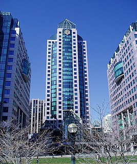
Toronto Township is a former municipality that is a geographic township in Mississauga, Ontario, Canada. It is directly to the west of the city of Toronto, and comprises land that makes up the majority of present-day Mississauga.
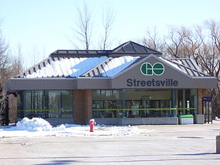
Streetsville GO Station is a GO Transit railway station on the Milton line in the Greater Toronto Area, Ontario, Canada. It is located in the community of Streetsville in Mississauga, basically resembling the atmosphere of a heritage site in a modern city. It is situated at 45 Thomas Street, near Britannia Road and Mississauga Road.

Mississauga—Erindale was a federal electoral district in Ontario, Canada, that was represented in the House of Commons of Canada from 2004 to 2015.
Meadowvale is a large suburban district located in the northwestern part of Mississauga, Ontario, Canada, just west of Toronto. In the 19th and early 20th centuries, Meadowvale Village in Toronto Township was established nearby and named for the meadows along the Credit River. By the 1970s the village would diminish with the current area to the west selected to be the site of a "new town" for the newly (1974) incorporated City of Mississauga and took the Meadowvale name. This newer section comprises the bulk of the district today.

Hurontario Street is a roadway running in Ontario, Canada between Lake Ontario at Mississauga and Lake Huron's Georgian Bay at Collingwood. Within Peel Region, it is a major urban thoroughfare within the cities of Mississauga and Brampton, which serves as the divide from which cross-streets are split into East and West, except at its foot in the historic Mississauga neighbourhood of Port Credit. Farther north, with the exception of the section through Simcoe County, where it forms the 8th Concession, it is the meridian for the rural municipalities it passes through. In Dufferin County, for instance, parallel roads are labelled as EHS or WHS for East of Hurontario Street. Due to its role as a divider for much of its length, most it was named Centre Road historically, and still is today in parts. The street's name is a portmanteau of the two terminating lakes: Huron and Ontario. Within much of Brampton, the road is named Main Street.
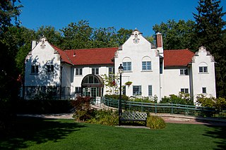
The Adamson Estate, which forms the eastern boundary of the Port Credit neighbourhood of Mississauga, Ontario, was purchased from the family of Agar Adamson by Credit Valley Conservation Authority in 1975 upon the urging of the local ratepayers group known as Project H21 after a proposed real estate development which would have changed the character of the neighbourhood. It is now a public park on the Waterfront Trail. It was recognized as a Historic Place in 1978.

Lakeview is one of the communities in Mississauga, in the Region of Peel, just east of Port Credit, which amalgamated into the Town of Mississauga in 1968. It is located in the extreme southeastern corner of the city. Lakeview is found along the northern shores of Lake Ontario, with an eastern boundary of Etobicoke Creek north of Lake Shore Road and the property line of the former Small Arms Division of Canadian Arsenals Ltd./Marie Curtis Park south of Lake Shore Road, and a western boundary of Cooksville Creek.
Erindale Secondary School is a Secondary School of the Peel District School Board serving the Erindale community of Western Mississauga, Ontario.

Toronto Gore was a township in Ontario, Canada. It is today split between Mississauga and Brampton.

Centennial Park is a large regional park with many sports facilities, maintained by the Parks, Forestry and Recreation Division of the city of Toronto, Ontario, Canada.

The Keele Valley landfill was the largest landfill in Canada and the third largest in North America during its operation. It was the primary landfill site for the City of Toronto and the regional municipalities of York and Durham from 1983 until 2002, and was owned and operated by the City of Toronto. It was located at the intersection of Keele Street and McNaughton Road in Maple, a community in the northeastern part of the City of Vaughan in Ontario.
The Hartland landfill is the waste disposal site for the city of Victoria, British Columbia and the Greater Victoria area. It was purchased by the Capital Regional District in 1975 and has been directly operated by its Environmental Sustainability Department since 1985. It is located in the District of Saanich on top of a hill, between Victoria and Sidney, at the end of Hartland Avenue. There is a public waste drop-off area, a recycling centre, a household hazardous waste collection facility and an electricity generating station that utilizes landfill gas as a fuel source. It has won several international environmental awards. At current disposal rates it is estimated that the landfill will be full by 2045.
Toronto Solid Waste Management is the municipal service that handles the transfer and disposal of garbage as well as the processing and sale of recyclable materials collected through the blue box program in Toronto, Ontario, Canada. It also coordinates programs to help residents and business reduce their production of waste.
The Green Lane landfill is a landfill in Southwold, Ontario, Canada, southwest of London. It is owned and operated by the City of Toronto as Toronto’s main landfill.

The Beare Road landfill was a landfill that operated in Scarborough, Ontario until 1983. The site is bounded by Finch Avenue East to the north, the Scarborough-Pickering Town Line to the east, CN Rail line to the west and hydro corridor to the south.
Brock Road landfills are a series of landfills used by Toronto from 1975 to 1990s. The North and West site are in Pickering, while the South site is in Ajax.

Mississauga—Streetsville is a provincial electoral district in Ontario, Canada, that has been represented in the Legislative Assembly of Ontario since 2007. This riding is centred on the villages of Streetsville and Meadowvale.
Mississauga—Erindale was a provincial electoral district in Ontario, Canada, that has been represented in the Legislative Assembly of Ontario since 2007.
GTAA Cogeneration Plant is a combined cycle natural gas and steam power station owned by the Greater Toronto Airports Authority, in Mississauga, Ontario. The plant is primarily used to supply steam and power to the Toronto Pearson International Airport with surplus power sold onto the Ontario grid. The plant is located across from the airport at Elmbank Road and Network Road next to the Central Utilities Plant.