Related Research Articles

Falmouth is a town in Cumberland County, Maine, United States. The population was 12,444 at the 2020 census. It is part of the Portland–South Portland–Biddeford, Maine metropolitan statistical area.

Long Island is an island town in Cumberland County, Maine, United States, which seceded from the city of Portland in 1993. The population was 234 at the 2020 census. It is part of the Portland–South Portland–Biddeford, Maine Metropolitan Statistical Area.

Casco Bay is an inlet of the Gulf of Maine on the southern coast of Maine, New England, United States. Its easternmost approach is Cape Small and its westernmost approach is Two Lights in Cape Elizabeth. The city of Portland sits along its southern edge and the Port of Portland lies within.

The Fore River is a short horn-shaped estuary, approximately 5.7 miles (9.2 km) long, separating Portland and South Portland in Maine in the United States. Many of the port facilities of the Portland harbor are along the estuary, which is formed just southwest of Portland by the confluence of several creeks. The estuary was initially known as Levett's River, so named by the first English settler of the Casco Bay region, Capt. Christopher Levett. But shortly afterwards, the estuary came to have the name by which it is known today.

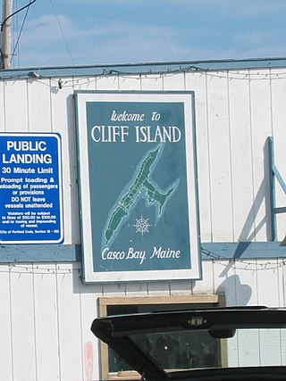
Cliff Island is an island in Casco Bay, Maine, United States. It is part of the city of Portland. As of the 2000 census, the island had a year-round population of approximately 60 people. In the summer, the island's population grows to about 200, despite the fact that it is the only year-round inhabited island in Casco Bay with no paved roads. The ZIP Code for Cliff Island is 04019.

Chebeague Island is located in Casco Bay, an inlet of the Gulf of Maine. It was originally used as a fishing ground by Abenaki Native Americans. Also known as Great Chebeague Island, today it is a town in Cumberland County, Maine, United States. It is located 10 miles (16 km) northeast of Portland, Maine. Chebeague Island is the largest island in Casco Bay that is not connected to the mainland by a bridge. The largest island is Sebascodegan, or "Great Island," which is part of the Town of Harpswell and connected to the mainland by a bridge.

Little Diamond Island is an island in Casco Bay, Maine, United States. It is part of the city of Portland.

Cushing Island, or Cushing's Island, is a privately owned island in Casco Bay in the U.S. state of Maine. Part of the city of Portland, roughly 45 families live there seasonally.


Great Diamond Island is an island in Casco Bay, Maine, United States. It is part of the city of Portland. At the 2000 census, the island had a year-round population of 77. The island is not accessible from the mainland by motor vehicle and has a limited network of roads. The primary modes of transportation are golf carts and bicycles. This fact has become a selling point for the island, marketing the area as "car free" and "kid friendly". The island was used as a military base starting in the late 19th century and continuing through World War II. After the base was decommissioned, the bunkers and residences were left idle for over 30 years before being developed and sold to private citizens.
Cow Island is a 26-acre (11 ha) island in Casco Bay, Maine, United States, off Great Diamond Island, about 3 miles (4.8 km) northeast of downtown Portland, and is part of the Town of Long Island in Cumberland County. A non-profit youth development organization called Rippleffect owns the island and has the responsibility to protect the island's natural ecosystem as well as the island's public access.
Hope Island is a privately owned island in Casco Bay near the city of Portland, Maine, United States. It is a part of the Town of Chebeague Island, in Cumberland County. The 89-acre (36 ha) island was considered for an LNG terminal. Developer John Cacoulidis and his wife Phyllis bought the island in 1993. In addition to the existing 10,000 sq. ft. house built in 1913 with nine bedrooms, seven bathrooms and five fireplaces, the Cacoulidises built there a separate 3,300-square-foot guest house, a boathouse with an apartment, and roads looping the island. They've also erected horse stables, a chicken coop, a garage and their own church, and for access both a boat dock and a helicopter pad. In a dispute over property taxes, the two part-time residents attempted but failed in a legislative effort to secede from the town of Cumberland.

The Cousins River is a 4.7-mile-long (7.6 km), primarily tidal river in southern Maine. Rising in the town of Freeport at the junction of Harvey Brook and Merrill Brook, it flows south and forms, for most of its course, the boundary between Freeport and Yarmouth. It flows into the Royal River just west of its mouth in Casco Bay.
The Crooked River is a 58.0-mile-long (93.3 km) tributary of the Songo River in Maine. It is the longest of the tributaries of Sebago Lake, the outlet of which is the Presumpscot River, flowing to Casco Bay on the Atlantic Ocean.

The Harraseeket River is a 3.2-mile-long (5.1 km) tidal river in the town of Freeport within the U.S. state of Maine. It forms a northern arm of Casco Bay.

Little River is a 4.1-mile-long (6.6 km) tributary of Casco Bay in Maine, United States.
The New Meadows River is a 12-mile-long (19 km) tidal embayment in Maine at the northern end of Casco Bay. It serves as the boundary between Cumberland and Sagadahoc counties for its entire length.
Casco Terrace is a community in Falmouth, Maine, United States, located on Falmouth Foreside on Casco Bay. Initially a community of summer cottages, it is now a year-round community of residents.

Jewell Island is a small island in Casco Bay, Maine, United States. Approximately 1 mile (1.6 km) long from southwest to northeast, it is located off the coast of Cliff Island, approximately eight miles from downtown Portland. It is a state-owned island with a small but protected harbor as well as camping and walking paths. Jewell Island was part of the Harbor Defenses of Portland fort network. The island is part of the city of Portland. Jewell Island can be reached by private or charter boats. There is no ferry service to the island.

Littlejohn Island is an island and census-designated place (CDP) in the town of Yarmouth in Cumberland County, Maine, United States. The population of the CDP was 118 at the 2010 census.
References
- Casco Bay (Map). 1:40,000. NOAA. 2011. Chart 13290.