Pasadena is a city in Los Angeles County, California, United States, located 11 miles (18 km) northeast of Downtown Los Angeles.
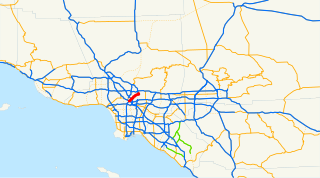
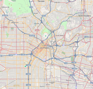
The Arroyo Seco Parkway, also known as the Pasadena Freeway, is the first freeway to be built in the United States. It connects Los Angeles with Pasadena alongside the Arroyo Seco seasonal river. It is notable not only for being the first, mostly opened in 1940, but for representing the transitional phase between early parkways and modern freeways. It conformed to modern standards when it was built, but is now regarded as a narrow, outdated roadway. A 1953 extension brought the south end to the Four Level Interchange in downtown Los Angeles and a connection with the rest of the freeway system.

Highland Park is a historic neighborhood in northeast Los Angeles, California. It was one of the first subdivisions of Los Angeles, and is inhabited by a variety of ethnic and socioeconomic groups.

Colorado Boulevard is a major east–west street in Southern California. It runs from Griffith Park in Los Angeles east through Glendale, the Eagle Rock section of Los Angeles, Pasadena, and Arcadia, ending in Monrovia. The full route was once various state highways but is now locally maintained in favor of the parallel Ventura Freeway (CA-134) and Foothill Freeway (I-210).
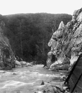
The Arroyo Seco, meaning "dry stream" in Spanish, is a 24.9-mile-long (40.1 km) seasonal river, canyon, watershed, and cultural area in Los Angeles County, California. The area was explored by Gaspar de Portolà who named the stream Arroyo Seco as this canyon had the least water of any they had seen. During this exploration he met the Chief Hahamog-na (Hahamonga) of the Tongva Indians.

Montecito Heights is a small district in Northeast Los Angeles. The population in 2000 was estimated at 16,768.

The Arroyo Seco Bicycle Path is an approximately 2 miles (3.2 km) long Class I bicycle path along the Arroyo Seco river channel in the Northeast Los Angeles region of Los Angeles County, California. It parallels to the Arroyo Seco Parkway also in the canyon.
Hermon is a small district in the city of Los Angeles, California. It is situated in a half square-mile valley bordered by the Arroyo Seco and the historic 110 freeway to the west, El Sereno to the south, and South Pasadena to the north and east. The community has been part of Los Angeles since 1912, but has retained its own unique identity. It is primarily a residential community, with a small business district in the center, one elementary school, a charter high school, two city parks, and an off-leash dog park opened in 2005.

San Fernando Road is a major street in the City of Los Angeles and Los Angeles County. Within the Burbank city limits it is signed as San Fernando Boulevard, and north of Newhall Pass it is signed as The Old Road. It was previously designated as Business Loop 5 in the 1970s.
Cypress Park is a densely populated, 82.1% Latino neighborhood of 10,000+ residents in Northeast Los Angeles, California. It sits in the river valley created by the Los Angeles River and the Arroyo Seco, and is surrounded by hills on three sides. It is the site of the Rio de Los Angeles State Park, the LA River Bike Path and other recreational facilities. It hosts one private and four public schools.

Memorial Park is a below-grade light rail station in the Los Angeles County Metro Rail system. It is located at Holly Street and Arroyo Parkway in Pasadena, California. The station is served by the Gold Line.

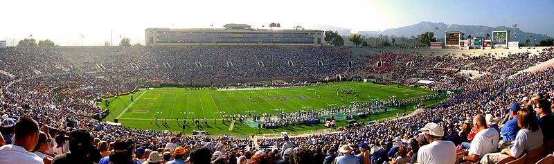
Brookside Golf Course is a municipal golf facility located in Pasadena, California, United States. Adjacent to the Rose Bowl stadium in the city's Arroyo Seco Natural Park, the 36-hole facility offers the C.W. Koiner Course (#1) and the shorter E.O. Nay Course (#2), divided by the concrete-channeled Arroyo Seco.

Eaton Canyon is a major canyon beginning at the Eaton Saddle near Mount Markham and San Gabriel Peak in the San Gabriel Mountains in the Angeles National Forest, United States. Its drainage flows into the Rio Hondo river and then into the Los Angeles River. It is named after Judge Benjamin S. Eaton, who lived in the Fair Oaks Ranch House in 1865 not far from Eaton Creek.

Kidspace Children's Museum is located next to the Rose Bowl in Pasadena, California, United States, housed in the former Fannie E. Morrison Horticultural Center.
Bellefontaine is a neighborhood in Pasadena, California, immediately south of Downtown. The neighborhood is bordered by Del Mar Boulevard to the north, Columbia Street to the south, Orange Grove Boulevard to the west, and Fair Oaks Avenue to the east. The main roads through the neighborhood are California Boulevard and Pasadena Avenue.
Lincoln-Villa is a neighborhood in Pasadena, California. It is bordered by Mountain Street to the north, Walnut Street to the south, Lincoln Avenue and Orange Grove Boulevard to the west, and Fair Oaks Avenue to the east.
Linda Vista is a neighborhood in Pasadena, California. It is one of Pasadena's wealthiest neighborhoods, and its largest by area. It is bordered by Oak Grove Drive to the north, Colorado Boulevard to the south, the Pasadena-Glendale border to the west, and Linda Vista Avenue to the east.
Lower Arroyo is a neighborhood in Pasadena, California, centered on the Arroyo Seco south of Brookside Park. It is bordered by Holly Street to the north, Columbia Street to the south, San Rafael Avenue to the west, and Orange Grove Boulevard to the east.
Villa Parke is a neighborhood in Pasadena, California,bordered by Mountain Street to the north, Interstate 210 to the south, Fair Oaks Avenue to the west, and Los Robles Avenue to the east.

Chandler School is an independent, co-ed day school for students in kindergarten through grade eight located in Pasadena, California United States, founded in 1950. School enrollment is 450 students. The 4.5-acre (1.8 ha) campus overlooks the Pasadena Rose Bowl and the Arroyo Seco.