
Millard County is a county in the U.S. state of Utah. As of the 2020 United States Census, the population was 12,975. Its county seat is Fillmore, and the largest city is Delta.
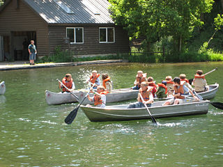
Scouting in Utah has a long history, from the 1910s to the present day, serving thousands of youth in programs that suit the environment in which they live.

Scouting in Wyoming has a long history, from the 1910s to the present day, serving thousands of youth in programs that suit the environment in which they live.

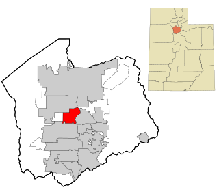
Murray is a city situated on the Wasatch Front in the core of Salt Lake Valley in the U.S. state of Utah. Named for territorial governor Eli Murray, and according to the 2020 census, Murray had a population of 50,637. Murray shares borders with Taylorsville, Holladay, South Salt Lake, Millcreek and West Jordan, Utah. Once teeming with heavy industry, Murray's industry mix has now shifted significantly toward healthcare, retail, and professional, scientific, and technical services. Known for its central location in Salt Lake County, Murray has been called the Hub of Salt Lake County. Unlike most of its neighboring communities, Murray operates its own police, fire, power, water, library, and parks and recreation departments and has its own school district. While maintaining many of its own services, Murray has one of the lowest city tax rates in the state.
Taylorsville is a city in Salt Lake County, Utah. It is part of the Salt Lake City metropolitan area. The population was 60,448 at the time of the 2020 census. Taylorsville was incorporated from the Taylorsville–Bennion CDP and portions of the Kearns metro township on July 1, 1996. The city is located adjacent to Interstate 215 and Bangerter Highway. It is located in the middle of the Salt Lake Valley.

Utah Lake State Park is a state park in Provo, Utah, United States. The park is located at the west end of Provo Center Street on the east shore of Utah Lake and immediately northwest of the Provo Municipal Airport.

Camp Floyd State Park Museum is a state park in the Cedar Valley in Fairfield, Utah, United States. The park includes a small part of the former Camp Floyd site, the Stagecoach Inn, and the Fairfield District School.

The State of Deseret was a proposed state of the United States, promoted by leaders of the Church of Jesus Christ of Latter-day Saints who had founded settlements in what is today the state of Utah. A provisional state government operated for nearly two years in 1849–50, but was never recognized by the United States government. The name Deseret derives from the word for "honeybee" in the Book of Mormon.

The Uinta Mountains are an east-west trending chain of mountains in northeastern Utah extending a short distance into northwest Colorado and slightly into southwestern Wyoming in the United States. As a subrange of the Rocky Mountains, they are unusual for being the highest range in the contiguous United States running east to west, and lie approximately 100 miles (160 km) east of Salt Lake City. The range has peaks ranging from 11,000 to 13,528 feet, with the highest point being Kings Peak, also the highest point in Utah. The Mirror Lake Highway crosses the western half of the Uintas on its way to Wyoming. Utah State Route 44 crosses the east end of the Uintas between Vernal and Manila.

Cache Valley(Shoshoni: Seuhubeogoi, “Willow Valley”) is a valley of northern Utah and southeast Idaho, United States, that includes the Logan metropolitan area. The valley was used by 19th century mountain men and was the site of the 1863 Bear River Massacre. The name, Cache Valley is often used synonymously to describe the Logan Metropolitan Area, one of the fastest growing metro areas in the US per capita — both in terms of economic GDP and population.

The Mormon pioneers were members of the Church of Jesus Christ of Latter-day Saints, also known as Latter-day Saints, who migrated beginning in the mid-1840s until the late-1860s across the United States from the Midwest to the Salt Lake Valley in what is today the U.S. state of Utah. At the time of the planning of the exodus in 1846, the territory comprising present-day Utah was part of the Republic of Mexico, with which the U.S. soon went to war over a border dispute left unresolved after the annexation of Texas. The Salt Lake Valley became American territory as a result of the Treaty of Guadalupe Hidalgo, which ended the war.

The International Society Daughters of Utah Pioneers is a women's organization dedicated to preserving the history of the original settlers of the geographic area covered by the State of Deseret and Utah Territory, including Mormon pioneers. The organization is open to any woman who is: (1) A direct-line descendant or legally adopted direct-line descendant with a pioneer ancestor; (2) the pioneer ancestor is a person who traveled to or through the geographic area covered by the State of Deseret/Utah Territory between July 1847 and 10 May 1869 ; (3) over the age of eighteen, and of good character. Travel through the geographic area covered by the State of Deseret/Utah Territory can be either east to west, west to east, north to south, or south to north.

Fort Douglas was established in October 1862, during the American Civil War, as a small military garrison about three miles east of Salt Lake City, Utah. Its purpose was to protect the overland mail route and telegraph lines along the Central Overland Route. It was officially closed in 1991 pursuant to BRAC action. A small portion of the fort remains in active military use as the Stephen A. Douglas Armed Forces Reserve Center, although it is expected the reserve center will be relocated in the next few years, after the state of Utah provided funds for the purpose in 2023.

The Great Salt Lake Council was a local council of the BSA (BSA) which is now part of the Crossroads of the West Council. The Great Salt Lake Council served the Utah counties of Salt Lake, Tooele and Summit, as well as much of Davis County. In April 2020, it combined with the former Trapper Trails and Utah National Parks councils.

The Utah Territory during the American Civil War was far from the main operational theaters of war, but still played a role in the disposition of the United States Army, drawing manpower away from the volunteer forces and providing its share of administrative headaches for the Lincoln Administration. Although no battles were fought in the territory, the withdrawal of Union forces at the beginning of the war allowed the Native American tribes to start raiding the trails passing through Utah. As a result, units from California and Utah were assigned to protect against these raids. Mineral deposits found in Utah by California soldiers encouraged the immigration of non-Mormon settlers into Utah.
The Trapper Trails Council is a former local council of the Boy Scouts of America that served areas in Northern Utah, Southern Idaho and Western Wyoming serving 18 districts. In April 2020, it combined with the former Great Salt Lake and Utah National Parks councils to create the new Crossroads of the West Council.

The Utah National Parks Council (UNPC) is a former local council of the Boy Scouts of America (BSA) that served youth in areas of Utah who live south of Salt Lake County and in some isolated areas of Nevada and Arizona. It was headquartered in Orem. As of December 31, 2013, UNPC was the largest of 272 local councils and is geographically within the Western Region of BSA. In 2011, the UNPC was recognized by the Utah Best of State Foundation as Utah's Best Humanitarian Organization. UNPC is a non-profit corporation governed by Scouting policies and a local community-based Executive Board. In April 2020, it combined with the former Great Salt Lake and Trapper Trails councils to create the new Crossroads of the West Council.

Ricks Spring is a karst spring, a natural water outflow from a cave in Logan Canyon within the Wasatch-Cache National Forest in northeast Utah. The spring is not an artesian source, but comes from the Logan River. Ricks Spring is the best known of several springs in an underground water network of the area.
Browne Lake may refer to:
Utahraptor State Park is a state park in Grand County, Utah, United States, about 14 miles (23 km) northwest of Moab.


