
Keston is a village in Greater London, England, located within the London Borough of Bromley, Greater London. Prior to 1965 it was within the historic county of Kent. It is part suburban, part rural in nature and lies on the edge of Hayes Common, just beyond the London conurbation to the south of Bromley Common. It includes the small hamlet of Nash to the southwest. The northern, more suburban part of Keston is sometimes referred to as Keston Mark.

Sandhurst is a town and civil parish in the Bracknell Forest borough in Berkshire, England. It is in the south eastern corner of Berkshire, and is situated 32 miles (51 km) west-southwest of central London, 2.5 miles (4.0 km) north west of Camberley and 5 miles (8.0 km) south of Bracknell. Sandhurst is known worldwide as the location of the Royal Military Academy Sandhurst. Despite its close proximity to Camberley, Sandhurst is also home to a large and well-known out-of-town mercantile development. The site is named "The Meadows" and has a Tesco Extra hypermarket and a Marks & Spencer, two of the largest in the country. A large Next clothing and homeware store is open on the site of the old Homebase.

A gated community is a form of residential community or housing estate containing strictly controlled entrances for pedestrians, bicycles, and automobiles, and often characterized by a closed perimeter of walls and fences. Historically, cities have built defensive city walls and controlled gates to protect their inhabitants, and such fortifications have also separated quarters of some cities. Today, gated communities usually consist of small residential streets and include various shared amenities. For smaller communities, these amenities may include only a park or other common area. For larger communities, it may be possible for residents to stay within the community for most daily activities. Gated communities are a type of common interest development, but are distinct from intentional communities.

Patchway is a town in South Gloucestershire, England, situated 10 km (6.2 mi) north-north west of central Bristol. The town has become an overflow settlement for Bristol and is contiguous with Bristol's urban area, along with the nearby towns of Filton and Bradley Stoke.

Treorchy is a town and community in Wales. Once a mining town, it retains such characteristics. Situated in the county borough of Rhondda Cynon Taf in the Rhondda Fawr valley. Treorchy is also one of the 16 communities of the Rhondda. It includes the villages of Cwmparc and Ynyswen.

Little Aston is a village in Staffordshire, England. It is located within the Lichfield District and is approximately 5 miles (8 km) south of the city of Lichfield. Formerly a separate settlement, it is in modern times contiguous with the built-up area of the neighbouring town of Sutton Coldfield. At the 2011 United Kingdom census the population of Little Aston ward was 2,920 people living in 1,104 households. At the last UK census there were 935 homes in the village, well over 10% of which were multimillion-pound properties, and the village is known for its footballers and successful businesspeople.
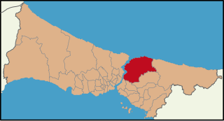
Beykoz, also known as Beicos and Beikos, is a district in Istanbul, Turkey at the northern end of the Bosphorus on the Anatolian side. The name is believed to be a combination of the words bey and kos, which means "village" in Farsi. Beykoz includes an area from the streams of Küçüksu and Göksu to the opening of the Bosphorus into the Black Sea, and the villages in the hinterland as far as the Riva creek. The mayor is Murat Aydın (AKP).
Bromley Common is the area of south-east London, within the London Borough of Bromley, Greater London. Prior to 1965 it was within the historic county of Kent. It lies south of Bromley town centre and Bickley, west of Southborough and Petts Wood, north of Locksbottom and Keston, and east of Hayes.

Kilifi is a town on the coast of Kenya, 56 kilometres (35 mi) northeast by road of Mombasa. The town lies on the Kilifi Creek and sits on the estuary of the Goshi River. Kilifi is capital of the Kilifi County and has a population of 122,899.

Stradone is a village located in County Cavan, Ireland. It is situated in the civil parish of Laragh six miles from Cavan, near the N3 road between Cavan and Virginia. Stradone is classified as a 'small village' in the Cavan County Council Development Plan 2014-2020.

Baldivis is a semi-rural residential suburb 46 kilometres (29 mi) south of Perth, and 11 kilometres (6.8 mi) southeast of the regional centre of Rockingham. It is located within the City of Rockingham local government area.

The Golden Triangle is a wedge-shaped area within the south western suburbs of Norwich, United Kingdom. The base of the Triangle is at the Colman Road stretch of the outer ring road, which is one mile south west of the city's inner ring, with the other two sides – Earlham Road and Newmarket Road – pointing into the city centre. The Unthank Road runs down the middle, forming the backbone and main shopping area of the Triangle. The Golden Triangle's terraces house professionals, families and many students from the nearby University of East Anglia; its friendly atmosphere has resulted in the Golden Triangle being dubbed the Norwich version of London's Notting Hill.

Sallynoggin is an area of Dublin in Ireland, in Dún Laoghaire–Rathdown county and the Dáil constituency of Dún Laoghaire. The area consists mainly of former local authority housing built between the late 1940s and the mid-1950s by the Corporation of Dún Laoghaire.

East Coast Road (ECR), combination of SH-49, NH-332A, NH-32, officially known as Mutthamizh Arignar Kalaignar Road, is a two-lane highway in Tamil Nadu, India, built along the coast of the Bay of Bengal connecting Tamil Nadu's state capital city Chennai with Kanyakumari via Puducherry, Cuddalore, Chidambaram, Sirkali, Thirukkadaiyur, Tharangambadi, Karaikal, Nagore, Nagapattinam, Thiruthuraipoondi, Muthupet, Adirampattinam, Manora, Manamelkudi, Mimisal, Ramanathapuram, Thoothukudi, Tiruchendur, Uvari, Kudankulam. The total length of the road is about 777 km between Chennai and Kanyakumari.

The A149 is commonly known as "The Coast Road" to local residents and tourists, as this road runs along the North Norfolk coast from King's Lynn to Cromer, via coastal villages.
The suburban district of Sketty is about 2 miles (3.2 km) west of the Swansea city centre on Gower Road. It falls within the Sketty council ward of Swansea. It is also a community.

Balatonföldvár is a popular resort town in Somogy County, Hungary, on the southern side of Lake Balaton, approximately 120 km southwest from Budapest and about 23 km southwest from Siófok, the "capital of Balaton". Balatonföldvár is a frequently visited tourist destination among Hungarians and foreign guests because of its natural beauties, historical heritages or its countless leisure opportunities. The town offer several water sport and mainland sport activities.
University Estate is a mainly residential suburb of Cape Town located at the foot of Devil's Peak to the east of the city. University Estate has the postcode 7925.

Nizampet is a satellite city of Hyderabad and a municipal corporation situated in Bachupally mandal, Medchal-Malkajgiri district of Telangana, India. It is administered as Nizampet Municipal Corporation.
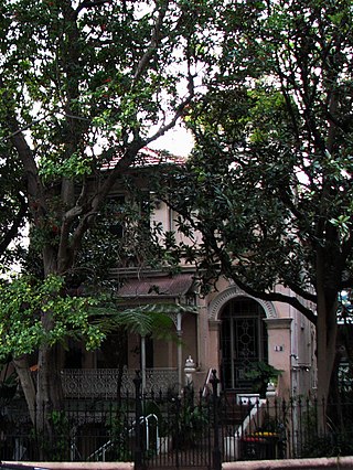
Oakleigh is a heritage-listed residence and former boarding house at 18 Ward Avenue in the inner city Sydney suburb of Potts Point in the City of Sydney local government area of New South Wales, Australia. It was built c. 1880 on the former estate of the now-demolished Goderich Lodge. It was added to the New South Wales State Heritage Register on 2 April 1999.
