The Brecon Beacons, or Bannau Brycheiniog, is a mountainous region and national park in Wales. Originally applied to the hills around Brecon, the names are now also used for the whole area covered by the Brecon Beacons National Park, also known as the Bannau Brycheiniog National Park, which includes the adjacent mountain ranges.

Powys is a county and preserved county in Wales. It borders Gwynedd, Denbighshire, and Wrexham to the north; the English ceremonial counties of Shropshire and Herefordshire to the west; Monmouthshire, Blaenau Gwent, Merthyr Tydfil, Caerphilly, Rhondda Cynon Taf, and Neath Port Talbot to the south; and Carmarthenshire and Ceredigion to the west. The largest settlement is Newtown, and the administrative centre is Llandridnod Wells.

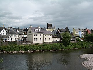
Brecon, archaically known as Brecknock, is a market town in Powys, mid Wales. In 1841, it had a population of 5,701. The population in 2001 was 7,901, increasing to 8,250 at the 2011 census. Historically it was the county town of Brecknockshire (Breconshire); although its role as such was eclipsed with the formation of the County of Powys, it remains an important local centre. Brecon is the third-largest town in Powys, after Newtown and Ystradgynlais. It lies north of the Brecon Beacons mountain range, but is just within the Brecon Beacons National Park.

Brecknockshire, also known as the County of Brecknock, Breconshire, or the County of Brecon is one of thirteen historic counties of Wales, and a former administrative county. Named after its county town of Brecon, the county is mountainous and primarily rural.

Pembrokeshire Coast National Park is a national park along the Pembrokeshire coast in west Wales.

Talgarth is a market town, community and electoral ward in southern Powys, Mid Wales, about 12 miles (19 km) north of Crickhowell, 19 miles (31 km) north-east of Brecon and 15 miles (24 km) south-east of Builth Wells. Notable buildings in the town include the 14th-century parish church and a defensive tower house. According to traditional accounts, Talgarth was the capital of the early medieval kingdom of Brycheiniog. It is in the historic county of Brecknockshire. In 2011, it had a population of 1,724.

Pen y Fan is the highest peak in South Wales, situated in Brecon Beacons National Park. At 886 metres (2,907 ft) above sea-level, it is also the highest British peak south of Cadair Idris in Snowdonia. It is the highest point of the historic county of Brecknockshire. The twin summits of Pen y Fan and Corn Du at 873 metres (2,864 ft) were formerly referred to as Cadair Arthur or 'Arthur's Seat'.

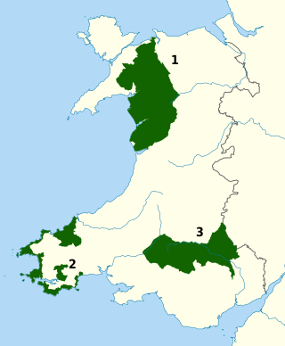
The national parks of Wales are managed areas of outstanding landscape in Wales, United Kingdom where some forms of development are restricted to preserve the landscape and natural environment. Together, they cover 20% of the land surface of Wales and have a resident population of over 80,000 people. Each National Park Authority is a free-standing body within the local government framework. At present, Wales has three national parks: Snowdonia, created in 1951, Pembrokeshire Coast (1952) and Brecon Beacons, and five areas of outstanding natural beauty (AONB), which together form the Protected areas of Wales. One of the AONBs, the Clwydian Range and Dee Valley has been proposed to be Wales' fourth national park.

Brychan Brycheiniog was a legendary 5th-century king of Brycheiniog in Mid Wales.

Trecastle is a village in Powys, Wales, situated on the edge of the Brecon Beacons National Park (Welsh: Parc Cenedlaethol Bannau Brycheiniog) and in the community of Llywel. The village has a population of about 200.

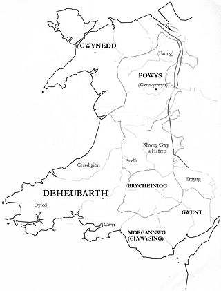
Brycheiniog was an independent kingdom in South Wales in the Early Middle Ages. It often acted as a buffer state between England to the east and the south Welsh kingdom of Deheubarth to the west. It was conquered and pacified by the Normans between 1088 and 1095, though it remained Welsh in character. It was transformed into the Lordship of Brecknock and later formed the southern and larger part of the historic county of Brecknockshire. To its south was the Kingdom of Morgannwg.

The Black Mountain is a mountain range in South, Mid and West Wales, straddling the county boundary between Carmarthenshire and Powys and forming the westernmost range of the Brecon Beacons National Park. Its highest point is Fan Brycheiniog at 802 metres or 2,631 ft. The Black Mountain also forms a part of the Fforest Fawr Geopark.
The Afon Pyrddin is a river forming a short section of the boundary between the counties of Brecknockshire and Glamorgan in Wales, Great Britain. It also forms a part of the boundary of the Brecon Beacons National Park, and the boundary of the unitary authorities of Powys and Neath Port Talbot. The river and its waterfalls are one of the key attractions of the Fforest Fawr Geopark designated in 2005.

The River Giedd is a principal tributary of the River Tawe, Wales. The river runs within the county of Powys and lies almost wholly within the Brecon Beacons National Park.

The Afon Twrch is a river which rises in the Black Mountain in south Wales. It forms the boundary between the counties of Brecknockshire and Carmarthenshire and, downstream of Ystradowen, between Brecknockshire and Glamorgan.
The Nant Gwys is a river flowing off the Black Mountain in Powys, Wales. Its tributaries Gwys Fawr and the Gwys Fach flow south from Banwen Gwyn and Bwlch y Ddeuwynt respectively and join forces to form the Nant Gwys proper which then flows for about 5 km / 3 mi to its confluence with the Afon Twrch at Cwm-twrch-Uchaf.

Fan Hir is a peak at the eastern end of the Black Mountain in the Brecon Beacons National Park in southern Wales. It is a subsidiary summit of Fan Brycheiniog. It falls within the county of Powys and is also a part of the traditional area of Fforest Fawr. Its Welsh name means "long peak", a fitting description, particularly if seen from the east when its steep eastern face is seen to advantage. It is about 2.5 miles or 4 km long and faces east. Its summit is 2490 feet above sea level. Fan Hir is separated from its higher neighbour to the north-west, Fan Brycheiniog by a col known as Bwlch Giedd, where a path rises from Llyn y Fan Fawr via a stone staircase.

Wales, a country that is part of the United Kingdom, contains protected areas under various designations. The largest designation by land area is Wales' three national parks, followed by the five Areas of Outstanding Natural Beauty.
Castle Tump is an early 11th-century motte and bailey castle in Trecastle, Powys, Wales.


