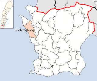
Helsingborg Municipality is a municipality in Skåne County in Sweden. Its seat is located in the city of Helsingborg, which is Sweden's eighth largest city. The municipality had a population of 132,011 on January 1, 2013, and the population is increasing with roughly 1500 people annually.

Bromölla Municipality is a municipality in Skåne County in South Sweden in southern Sweden. Its seat is located in the town Bromölla.

Sölvesborg Municipality is a municipality in Blekinge County in South Sweden in southern Sweden. It borders to Bromölla Municipality, Olofström Municipality and Karlshamn Municipality. The town Sölvesborg is the seat of the municipality.

The Second Treaty of Brömsebro was signed on 13 August 1645, and ended the Torstenson War, a local conflict that began in 1643 between Sweden and Denmark-Norway. Negotiations for the treaty began in February the same year.

The Torne, also known as the Tornio, is a river in northern Sweden and Finland. For approximately half of its length it defines the border between these two countries. It rises at Lake Torne near the border with Norway and flows generally southeast for a distance of 522 kilometres (324 mi) into the Gulf of Bothnia. It is the largest river in Norrbotten both by length and by watershed area.
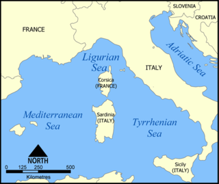
The Ligurian Sea is an arm of the Mediterranean Sea, between the Italian Riviera (Liguria) and the island of Corsica. The sea is theorized to be named after the ancient Ligures people.
The Jinzū River is a river that flows from Gifu Prefecture to Toyama Prefecture in Japan. It is called Miya River in Gifu. It is 120 km (75 mi) in length and has a watershed of 2,720 km2 (1,050 sq mi).

The European route E 22 is one of the longest European routes. It has a length of about 5,320 km (3,310 mi). Many of the E-roads have been extended into Asia since the year 2000; the E 22 was extended on 24 June 2002.
Mežotne is a town in Latvia 10 km west of Bauska and 40 km south of the capital of Latvia, Riga. It lies in the historical region of Zemgale on the left bank of the Lielupe river near the Lithuanian border.

Gwadar Bay is located in the Gulf of Oman on the maritime border of Pakistan and Iran. The name is from Persian, Khalij-e Gavader or "Gulf of Gwadar" on the Arabian Sea. It is an inlet of the Arabian Sea indenting the sandy Makran coast at the Iran–Pakistan border. It is about 30 kilometres (20 mi) long and 16 kilometres (10 mi) wide. The Dashtiari River flows into it from the northwest, and the Dasht River from the northeast. The town of Jiwani is located on the eastern end of the Gwadar Bay. The port city of Gwadar lies about 50 kilometres (30 mi) to the east, while the sister port city of Chabahar is located about 100 kilometres (62 mi) to the west of the Gwadar Bay.

The Oglio is a left-side tributary of the Po River in Lombardy, Italy. It is 280 kilometres (170 mi) long. In the hierarchy of the Po's tributaries, with its 280 kilometres (170 mi) of length, it occupies the 2nd place per length, while it is the 4th per basin surface, and the 3rd per average discharge at the mouth.
Kherlen River is a river of 1,254 km length in Mongolia and China.

Snakov is a village and municipality in Bardejov District in the Prešov Region of north-east Slovakia.
German submarine U-317 was a Type VIIC/41 U-boat of Nazi Germany's Kriegsmarine during World War II.

Nagydobos is a village in Szabolcs-Szatmár-Bereg county, in the Northern Great Plain region of eastern Hungary.

Białorzeczka, is a village in the administrative district of Gmina Giby, within Sejny County, Podlaskie Voivodeship, in north-eastern Poland, close to the border with Lithuania. It lies approximately 9 kilometres (6 mi) south-west of Sejny and 105 km (65 mi) north of the regional capital Białystok.
Révleányvár is a village in Borsod-Abaúj-Zemplén County in northeastern Hungary.

Kuppam is a river located at Taliparamba in Kannur District of Kerala state, India. The river flows into the Arabian Sea. The river touches Taliparamba town at a place called Kupam which is surrounded by seven small hills.

Spoorwijk is a residential neighbourhood in the Laak district of The Hague, Netherlands. Its name, literally rail neighbourhood or track neighbourhood, originated from the fact that the area borders the Amsterdam–Haarlem–Rotterdam railway on the west. The neighbourhood has 4,161 inhabitants and covers an area of 33,3 ha.


