Mount Bulusan is a stratovolcano on the island of Luzon in the Philippines.
Bulusan may also refer to:
- Bulusan (municipality), Sorsogon, Philippines
- Lake Bulusan, Luzon Island, Philippines
Mount Bulusan is a stratovolcano on the island of Luzon in the Philippines.
Bulusan may also refer to:
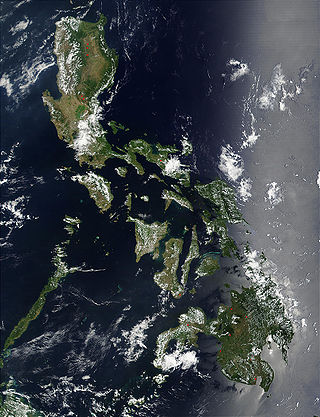
The Philippines is an archipelago that comprises 7,641 islands with a total land area of 300,000 square kilometers (115,831 sq mi). It is the world's fifth largest island country. The eleven largest islands contain 95% of the total land area. The largest of these islands is Luzon at about 105,000 square kilometers (40,541 sq mi). The next largest island is Mindanao at about 95,000 square kilometers (36,680 sq mi). The archipelago is around 800 kilometers (500 mi) from the Asian mainland and is located between Taiwan and Borneo.

Luzon is the largest and most populous island in the Philippines. Located in the northern portion of the Philippines archipelago, it is the economic and political center of the nation, being home to the country's capital city, Manila, as well as Quezon City, the country's most populous city. With a population of 64 million as of 2021, it contains 52.5% of the country's total population and is the fourth most populous island in the world. It is the 15th largest island in the world by land area.

Sorsogon, officially the Province of Sorsogon, is a province in the Philippines located in the Bicol Region. It is the southernmost province in Luzon and is subdivided into fourteen municipalities (towns) and one city. Its capital is Sorsogon City and borders the province of Albay to the north.
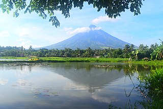
Bicol, known formally as the Bicol Region or colloquially as Bicolandia, is an administrative region of the Philippines, designated as Region V. Bicol comprises six provinces, four on the Bicol Peninsula mainland – Albay, Camarines Norte, Camarines Sur, and Sorsogon – and the offshore island provinces of Catanduanes and Masbate.

Central Luzon, designated as Region III, is an administrative region in the Philippines, primarily serving to organize the 7 provinces of the vast central plains of the island of Luzon, for administrative convenience. The region contains the largest plain in the country and produces most of the country's rice supply, earning itself the nickname "Rice Granary of the Philippines". Its provinces are: Aurora, Bataan, Bulacan, Nueva Ecija, Pampanga, Tarlac and Zambales. Pangasinan was formerly a province of Central Luzon before President Marcos signed Presidential Decree No. 1, 1972, incorporating it into Ilocos Region. Additionally, the province of Aurora was part of the defunct political region Southern Tagalog when the region was divided into Calabarzon and Mimaropa, upon the issuance of Executive Order No. 103, dated May 17, 2002, by then-President Gloria Macapagal Arroyo, which transferred Aurora to Central Luzon.
The Philippine archipelago is one of the world's great reservoirs of biodiversity and endemism. The archipelago includes over 7000 islands, and a total land area of 300,780 km².

Bulusan, officially the Municipality of Bulusan, is a 4th class municipality in the province of Sorsogon, Philippines. According to the 2020 census, it has a population of 23,932 people.

Calapan, officially known as the City of Calapan, is a 3rd class component city and capital of the province of Oriental Mindoro, Philippines. According to the 2020 census, it has a population of 145,786 people.

Mount Bulusan, also known as Bulusan Volcano, is a stratovolcano on the island of Luzon in the Philippines. Located in the province of Sorsogon in the Bicol Region, it is 70 kilometres (43 mi) southeast of Mayon Volcano and approximately 390 kilometres (240 mi) southeast of the Philippine capital of Manila.
Luzon earthquake may refer to:
Isabela may refer to:

The Roman Catholic Diocese of Sorsogon is a diocese of the Latin Rite of the Roman Catholic Church in the Philippines. The diocese was established in 1951 by the Archdiocese of Caceres, and in 1968, the diocese was subdivided after the Diocese of Masbate separated. The diocese is a suffragan of the Archdiocese of Caceres.
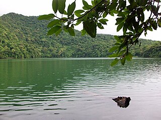
Lake Bulusan is a lake on Luzon Island in the Philippines. It lies at the heart of Bulusan Volcano National Park which covers a land area of 3,672 hectares. It has an elevation of 360 metres (1,180 ft) and is located on the southeast flank of Mount Bulusan, an active volcano.
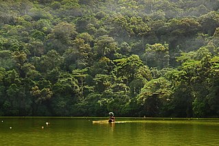
The Bulusan Volcano Natural Park is a 3,673-hectare (9,080-acre) protected area of rainforest surrounding Mount Bulusan in the Philippines. It was first designated as a National Park by Proclamation no. 811 on June 7, 1935. Under the National Integrated Protected Areas System (NIPAS) of 1992 managed by the Department of the Environment and Natural Resources, the park was reclassified as a Natural Park by Proc. 421 on November 27, 2000. The area features the volcano itself, Bulusan Lake, the two other mountains known as the 'Sharp Peak' and 'Hormahan' and Lake Aguingay. The park is in the south central part of Sorsogon Province, southern Luzon, Bicol Region, Philippines, bounded by five municipalities: Bulusan, Barcelona, Irosin, Juban and Casiguran.

Lake Aguingay is a vast plain at the center of Bulusan Volcano National Park located near Bulusan Lake at the Municipality of Bulusan, South central part of the Sorsogon Province, Southern Luzon, Bicol Region, Philippines. It is called The Lake because it is occasionally flooded during wet season and dries up during summer. When it is wet it resembles a big lake located right at the foot of Mt. Bulusan. The area is home to various endemic birds, reptiles and other mammals. It is surrounded by lush vegetation and a tropical rain forest. It is only accessible by foot from Bulusan Lake and from the villages of Kapangihan and San Roque.
Aguingay or Agingay is a legendary lady mistress of the warrior of Bulusan in the town's most popular folklore. She is the main character of the epic: Si Bulusan nan Si Aguingay believed to have existed hundred of years before Spaniards set foot in the islands of the Philippines.
The siege of Masbate was fought on August 19, 1898 on Masbate island as a part of the Philippine Revolution.
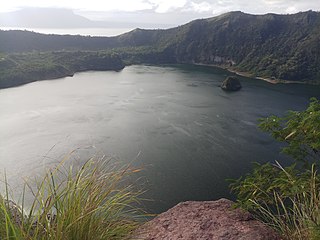
The Luzon rain forests is a tropical moist broadleaf forest ecoregion on the island of Luzon. Luzon is the largest island in the Philippines, and the Luzon rain forests is the most extensive rainforest ecoregion of the country. The ecoregion includes the lowlands of Luzon and neighboring islands below 1000 meters elevation. Very little of the original rainforest remains, and the status of this area is critical/endangered.
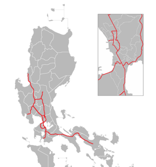
The Philippine expressway network, also known as the High Standard Highway Network, is a controlled-access highway network managed by the Department of Public Works and Highways (DPWH) which consists of all expressways and regional high standard highways in the Philippines.

The Luzon montane rain forests is a tropical moist broadleaf forest ecoregion on the island of Luzon in the Philippines. The ecoregion is located on several volcanic and non-volcanic mountains of the island. Luzon is the largest and northernmost major island of the Philippines, located in the western Pacific Ocean.