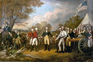
The Battles of Saratoga marked the climax of the Saratoga campaign, giving a decisive victory to the Americans over the British in the American Revolutionary War. British General John Burgoyne led a large invasion army southward from Canada in the Champlain Valley, hoping to meet a similar British force marching northward from New York City and another British force marching eastward from Lake Ontario; the southern and western forces never arrived, and Burgoyne was surrounded by American forces in upstate New York. He fought two small battles to break out which took place 18 days apart on the same ground, 9 miles (14 km) south of Saratoga, New York. They both failed.

Canada has a large domestic and foreign tourism industry. The second largest country in the world, Canada's incredible geographical variety is a significant tourist attractor. Much of the country's tourism is centred in the following (busiest) regions: Toronto, Montreal, Vancouver/Whistler, Niagara Falls, Vancouver Island, Calgary/Canadian Rockies, British Columbia's Okanagan Valley, and the national capital region Ottawa. The large cities are known for their culture, diversity, as well as the many national parks and historic sites.

The Peace River is a 1,923-kilometre-long (1,195 mi) river in Canada that originates in the Rocky Mountains of northern British Columbia and flows to the northeast through northern Alberta. The Peace River joins the Athabasca River in the Peace-Athabasca Delta to form the Slave River, a tributary of the Mackenzie River. The Finlay River, the main headwater of the Peace River, is regarded as the ultimate source of the Mackenzie River. The combined Finlay–Peace–Slave–Mackenzie river system is the 13th longest river system in the world.

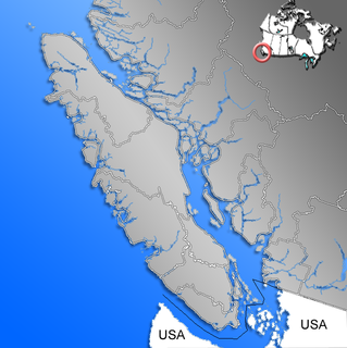
Port Hardy is a district municipality in British Columbia, Canada located on the northeastern end of Vancouver Island. Port Hardy has a population of 4,132 at last census (2016). It is the gateway to Cape Scott Provincial Park, the North Coast Trail and the BC Marine Trail, located on the northernmost tip of Vancouver Island. The community has access to spectacular wilderness adventures, such as kayaking, caving, world-class scuba diving, nature viewing, surfing, unique saltwater rapids, fishing and camping.
Andy Bailey Provincial Park is a provincial park in British Columbia, Canada, located 28 kilometres southeast of Fort Nelson, British Columbia. The park is 196 hectares in size and aims to protect black and white spruce forests, moose, beavers, foxes and songbirds.

Mount Maxwell Provincial Park is a provincial park in the Gulf Islands of British Columbia, Canada. It is located on Burgoyne Bay and the Sansum Narrows on the western shores of Saltspring Island.
Mount Pope Provincial Park is a provincial park in British Columbia, Canada, located 7km northwest of Fort St. James in the Omineca Country region of that province's Central Interior. Mount Pope is about 1420 meters high and composed of limestone. The trail to the summit from Stones Bay Road gains about 700m and may be followed year-round. There are a few dozen developed rock climbs up to seven pitches long on the lower flanks of the mountain.

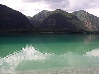
Muncho Lake Provincial Park is a provincial park in British Columbia, Canada, located on the Alaska Highway as it transits the northernmost Canadian Rockies west of Fort Nelson. The park is part of the larger Muskwa-Kechika Management Area. It is named after Muncho Lake, which is in the park and is both the name of the lake and of the community located there.
Paarens Beach Provincial Park is a provincial park in central British Columbia, Canada. It is located on the south-west shore of Stuart Lake, to the west of Fort St. James.

Shannon Falls Provincial Park is a provincial park in British Columbia, Canada. It is located 58 kilometers (36 mi) from Vancouver and 2 kilometers (1.2 mi) south of Squamish along the Sea to Sky Highway. Shannon Falls is the third highest waterfall in British Columbia.
Smith River Falls – Fort Halkett Provincial Park is a provincial park in British Columbia, Canada, protecting Smith River Falls and the former Fort Halkett, a Hudson's Bay Company trading post. The park is located at the confluence of the Smith and Liard Rivers.
The American Elm cultivar Ulmus americana 'Kimley' was cloned by the Sheridan Nurseries, Mississauga, Canada, from a large tree found near Oshawa, Ontario, Canada.
The American Elm cultivar Ulmus americana 'Queen City' was a selection made c. 1944 from a tree growing on the Lake Shore Boulevard in Toronto, Ontario, Canada.

The elm cultivar Ulmus 'Scampstoniensis', the Scampston Elm or Scampston Weeping Elm, is said to have come from Scampston Hall, Yorkshire, England, before 1810. Loudon opined that a tree of the same name at the Royal Horticultural Society's Garden in 1834, 18 feet (5.5 m) high at 8 years old "differed little from the species". Henry described the tree, from a specimen growing in Victoria Park, Bath, as "a weeping form of U. nitens" [:Ulmus minor ]; however Green considered it "probably a form of Ulmus × hollandica". Writing in 1831, Loudon said that the tree was supposed to have originated in America. U. minor is not, however, an American species, so if the tree was brought from America, it must originally have been taken there from Europe. There was an 'American Plantation' at Scampston, which may be related to this supposition. A number of old specimens of 'Scampstoniensis' in this plantation were blown down in a great gale of October 1881; younger specimens were still present at Scampston in 1911.
The putative American Elm cultivar Ulmus americana 'Burgoyne' was grown at the Arnold Arboretum until removed in 1988. The tree was raised from seeds of the Burgoyne Elm, grown for the town of Weston, Massachusetts, in 1965. The name of the tree was first noted in records of the Plant Sciences Data Center of the American Horticultural Society, but is not formally recognized as a valid cultivar.
This is a list of elections in Canada in 2009. Included are provincial, municipal and federal elections, by-elections on any level, referendums and party leadership races at any level.

The following outline is provided as an overview of and topical guide to British Columbia:


