
Duncan is a city on southern Vancouver Island in British Columbia, Canada. It is the smallest city by area in Canada. It was incorporated in 1912.

Ganges, British Columbia is an unincorporated community on Salt Spring Island in the province of British Columbia, Canada.
Burgoyne Bay Provincial Park is a provincial park in British Columbia, Canada located on southwestern Saltspring Island near Fulford Harbour. The parks faces northwest to Sansum Narrows, which is the channel between Saltspring Island and Vancouver Island. Mount Maxwell Provincial Park lies adjacent to the north.

Mount Maxwell Provincial Park is a provincial park in the Gulf Islands of British Columbia, Canada. It is located on Burgoyne Bay and the Sansum Narrows on the western shores of Saltspring Island.
Wallace Island Marine Provincial Park is a provincial park in the Gulf Islands of British Columbia, Canada. The park includes almost all 72 hectares of Wallace Island. Land on the northern side of Princess Cove extending north towards Chivers is private. This long, thin island lies in Trincomali Channel south-west of Galiano Island, and about 2 km (1.2 mi) northeast of Saltspring Island. There are a few hiking trails, and camping is permitted in designated areas.
North Secretary Island is located in the Gulf Islands where Trincomali Channel and Houstoun Passage meet in the Gulf Islands region of the South Coast of British Columbia, Canada. It is 138 acres (0.56 km2) in size and is located in Trincomali Channel as part of the Secretary Islands group off the north tip of Saltspring Island. There are two islands in the Secretary Islands group, the southern being named South Secretary and the larger one being named North Secretary Island. There is another Secretary Island in British Columbia, in Sooke Basin.

Moresby Island is one of the Gulf Islands of British Columbia, located on the west side of Swanson Channel and east of the southern end of Saltspring Island. It is not to be confused with Moresby Island, the second largest of the Haida Gwaii Islands off the north coast of BC. It is currently a privately owned island, and is used by its current owners to raise beef cattle. The island is not open to the general public. Its current population is 2 people, a manager and his wife.

Fanny Bay is an unincorporated community in the Canadian province of British Columbia. It is located on Baynes Sound on the east coast of Vancouver Island. It has a population of 921. It is best known for its fine oysters. The area is served by the Island Highway.
Maple Bay is a seaside community located in the Cowichan Valley of southern Vancouver Island, British Columbia, Canada. A narrow inlet and surrounded by smooth, pebbled beaches, Maple Bay is home to marine activity all year round. Maple Bay is a small town with a population of 2,640.
Point Grey is a headland marking the southern entrance to English Bay and Burrard Inlet in British Columbia, Canada. The headland is the site of Wreck Beach, Tower Beach, Point Grey Beach and most notably, since 1925, on its top is the Point Grey Campus of the University of British Columbia.
Sturdies Bay is on the south east part of Galiano Island in British Columbia, Canada's Gulf Islands. It is known primarily for its ferry terminal, that connects it to the Tsawwassen Ferry Terminal and the other southern Gulf Islands. At the ferry terminal there is also a public dock, serviced in the summer by an inter-island water taxi, and in the school year the same vessel picks up students here to bring them to schools on Pender and Saltspring Islands.
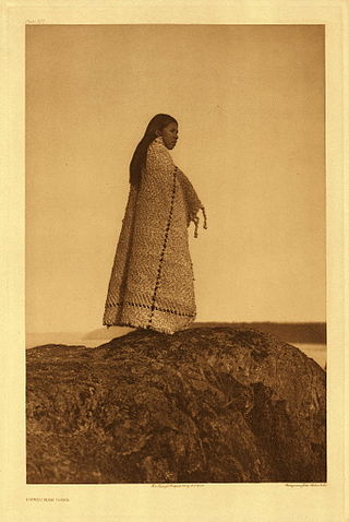
Cowichan Tribes is the band government of the Cowichan, a group of Coast Salish peoples who live in the Cowichan Valley region on Vancouver Island. With over 3,800 registered members, it is the single largest First Nations band in British Columbia.
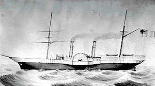
The Labouchere was a paddle steamer in the service of the Hudson's Bay Company, built in 1858 at Green's in Blackwall, London, England. Under the command of Captain J. Trivett it was mostly in service in British Columbia and the rest of the Pacific Northwest in the 1850s and 1860s, including the Stikine lisière in Russian America. In 1859, its then-captain John Swanson was elected by a "celebrated" majority of one in the colonial riding of Nanaimo for the Legislative Assembly of the Colony of Vancouver Island.

Salt Spring Island or Saltspring Island is one of the Gulf Islands in the Strait of Georgia between mainland British Columbia, Canada, and Vancouver Island.

Portland Island is an island of the Southern Gulf Islands of the South Coast of British Columbia, Canada. It is located in the Salish Sea west of Moresby Island and off the south tip of Saltspring Island, adjacent to the main BC Ferries route just offshore from the terminal at Swartz Bay at the tip of the Saanich Peninsula. It was named after HMS Portland, the flagship of Rear-Admiral Fairfax Moresby, Commander in Chief of the Pacific Station 1850–1853.
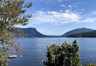
Sansum Narrows is a strait or channel between Vancouver Island (W) and Saltspring Island (E) in the Southern Gulf Islands region of British Columbia, Canada. The narrows are between Maple Bay and Tl’ulpalus.

Trincomali Channel is a channel between Galiano Island and Saltspring Island in the Gulf Islands of British Columbia, Canada.
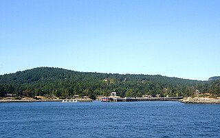
Vesuvius, also known as Vesuvius Bay, is an unincorporated settlement and ferry terminal on the northwest coast of Saltspring Island in the Gulf Islands of British Columbia, Canada. It is the eastern terminus of a ferry which connects Saltspring Island to Vancouver Island across Sansum Narrows to Crofton, which is just north of the city of Duncan.

Cowichan was a steamship which was operated in British Columbia under the ownership of the Union Steamship Company. Cowichan sank in 1925 following a collision with another ship.
Stuart Channel is a strait in the Gulf Islands region of the Gulf of Georgia, separating Vancouver Island on the west from Thetis, DeCourcy and Penelakut (Kuper) Islands on the east. Ladysmith Harbour and the town of Chemainus face onto it from Vancouver Island. It is crossed by a BC Ferries route serving Thetis and Penelakut Islands.
