

Ganges, British Columbia is an unincorporated community on Salt Spring Island in the province of British Columbia, Canada.
Ganges, British Columbia is an unincorporated community on Salt Spring Island in the province of British Columbia, Canada.
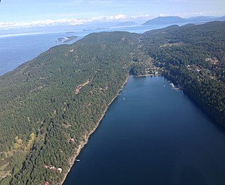
Ganges Harbour, from which Ganges takes its name, was originally called Admiralty Bay but was renamed by Captain Richards in 1859 after HMS Ganges, and indirectly after the Ganges river in South Asia. The ship was at the Pacific Station from 1857 to 1860 under the command of Captain John Fulford as flagship of Rear Admiral Robert L. Baynes. Ganges was the last sailing line-of-battle ship in foreign service. The first house on Salt Spring Island was built here in 1859 by the first group of 20 settlers that arrived on the island that summer. On 4 July 1860 the harbour was the scene of the killing of eight Bella Bella (Heiltsuk) people and the capture of three women and two boys for slaves by the Cowichans. A few days later, two Cowichans were beheaded, by a band from Fort Rupert. [1] : 198
| Climate data for Saltspring Island (St. Mary's Lake) 1981–2010 normals | |||||||||||||
|---|---|---|---|---|---|---|---|---|---|---|---|---|---|
| Month | Jan | Feb | Mar | Apr | May | Jun | Jul | Aug | Sep | Oct | Nov | Dec | Year |
| Record high °C (°F) | 14.0 (57.2) | 15.0 (59.0) | 19.5 (67.1) | 25.5 (77.9) | 29.5 (85.1) | 31.5 (88.7) | 33.5 (92.3) | 32.0 (89.6) | 31.5 (88.7) | 25.5 (77.9) | 16.0 (60.8) | 17.0 (62.6) | 33.5 (92.3) |
| Average high °C (°F) | 6.5 (43.7) | 7.8 (46.0) | 10.4 (50.7) | 13.5 (56.3) | 17.1 (62.8) | 20.1 (68.2) | 22.7 (72.9) | 22.8 (73.0) | 19.5 (67.1) | 13.8 (56.8) | 8.8 (47.8) | 6.1 (43.0) | 14.1 (57.4) |
| Daily mean °C (°F) | 4.3 (39.7) | 5.0 (41.0) | 7.0 (44.6) | 9.6 (49.3) | 12.9 (55.2) | 15.8 (60.4) | 18.1 (64.6) | 18.4 (65.1) | 15.4 (59.7) | 10.8 (51.4) | 6.6 (43.9) | 4.1 (39.4) | 10.7 (51.3) |
| Average low °C (°F) | 2.0 (35.6) | 2.2 (36.0) | 3.5 (38.3) | 5.6 (42.1) | 8.7 (47.7) | 11.5 (52.7) | 13.5 (56.3) | 13.9 (57.0) | 11.3 (52.3) | 7.7 (45.9) | 4.3 (39.7) | 2.1 (35.8) | 7.2 (45.0) |
| Record low °C (°F) | −10.0 (14.0) | −10.5 (13.1) | −6.0 (21.2) | −1.0 (30.2) | 2.0 (35.6) | 4.4 (39.9) | 5.0 (41.0) | 8.0 (46.4) | 5.0 (41.0) | −3.0 (26.6) | −10.0 (14.0) | −11.0 (12.2) | −11.0 (12.2) |
| Average precipitation mm (inches) | 162.1 (6.38) | 98.5 (3.88) | 88.6 (3.49) | 56.8 (2.24) | 43.0 (1.69) | 37.4 (1.47) | 23.2 (0.91) | 28.0 (1.10) | 33.1 (1.30) | 94.0 (3.70) | 167.9 (6.61) | 154.3 (6.07) | 987.0 (38.86) |
| Average rainfall mm (inches) | 152.0 (5.98) | 95.5 (3.76) | 86.2 (3.39) | 56.8 (2.24) | 43.0 (1.69) | 37.4 (1.47) | 23.2 (0.91) | 28.0 (1.10) | 33.1 (1.30) | 93.5 (3.68) | 163.5 (6.44) | 142.8 (5.62) | 955 (37.58) |
| Average snowfall cm (inches) | 10.1 (4.0) | 3.1 (1.2) | 2.4 (0.9) | 0.0 (0.0) | 0.0 (0.0) | 0.0 (0.0) | 0.0 (0.0) | 0.0 (0.0) | 0.0 (0.0) | 0.5 (0.2) | 4.4 (1.7) | 11.5 (4.5) | 32 (12.5) |
| Average precipitation days (≥ 0.2 mm) | 19.4 | 15.7 | 17.4 | 14.5 | 11.6 | 9.9 | 5.8 | 5.7 | 7.7 | 15.2 | 20.9 | 20.4 | 164.2 |
| Average rainy days | 18.3 | 15.2 | 17.1 | 14.5 | 11.6 | 9.9 | 5.8 | 5.7 | 7.7 | 15.1 | 20.2 | 19.2 | 160.3 |
| Average snowy days (≥ 0.2 cm) | 1.7 | 0.9 | 0.6 | 0 | 0 | 0 | 0 | 0 | 0 | 0.1 | 1.0 | 1.8 | 6.1 |
| Source: Environment Canada [2] | |||||||||||||
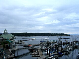
Ganges is the main service centre on the island, with several grocery stores, numerous restaurants and art galleries, banks and a variety of other services. The main fire hall for the island, the local Royal Canadian Mounted Police detachment, and the hospital are all located in Ganges. Ganges is the home of Salt Spring Coffee, which also sells its coffee on BC Ferries.

The harbour has several marinas, and is the home base for a Canadian Coast Guard cutter. It is also a busy seaplane aerodrome, with several scheduled flights a day to Vancouver. Because of Ganges' relatively central location in the Gulf Islands, it is a popular stop for recreational boaters.
One of the major tourist attractions in Ganges is the market that takes place on Saturdays during the summer months. At this market, many of the island's crafters and farmers offer goods and produce ranging from homemade honey to clothing and art.
The Ganges Market runs every Saturday from 8:30 to 4:00, from April to October. [3] Over hundreds of vendors sell produce, baked goods, soaps, lotions, art, jewelry, pottery, and other crafts under the rule that you must: "Make it, bake it, or grow it". [4] Attractions include local buskers, SPCA dog care, the nearby playground, and neighboring shops. It is located in Centennial Park, Ganges and the surrounding area.

Vancouver Island is an island in the northeastern Pacific Ocean and part of the Canadian province of British Columbia. The island is 456 km (283 mi) in length, 100 km (62 mi) in width at its widest point, and 32,134 km2 (12,407 sq mi) in area. The island is the largest by area and the most populous along the west coasts of the Americas.

Harbour Air Seaplanes is a scheduled floatplane service, tour and charter airline based in Richmond, British Columbia, Canada. The predominantly seaplane airline specializes in routes between Vancouver, Nanaimo, Victoria, Sechelt, Comox, Whistler and the Gulf Islands, primarily with de Havilland Canada floatplanes. Along with Westcoast Air, Salt Spring Air and Whistler Air, it operates de Havilland Beavers, Otters and Twin Otters.

Mayne Island is a 21-square-kilometre (8.1 sq mi) island in the southern Gulf Islands chain of British Columbia. It is midway between the Lower Mainland of BC and Vancouver Island, and has a population of 995. Mount Parke in the south-central heart of the island is its highest peak at 255 metres.
Crofton is a small west coast town within the District of North Cowichan of southern Vancouver Island in British Columbia, east of BC Highway 1 about 74 kilometres (46 mi) north of Victoria.

North Cowichan is a district municipality established in 1873 on Vancouver Island, in British Columbia, Canada. The municipality is part of the Cowichan Valley Regional District. North Cowichan is noted for a landscape including forests, beaches, rivers, and lakes. The municipality encompasses the communities of Chemainus; Westholme; Crofton; Maple Bay; and "the South End". The latter is an informal name for a built-up area which is essentially a suburb of the City of Duncan, a separate municipality.

Thetis Island is an island and unincorporated community off the coast of British Columbia, Canada, lying between Vancouver Island, which is to the west across Stuart Channel, and the west from the north tip of Galiano Island, from which it is separated by Trincomali Channel. With its immediate southern neighbour Penelakut Island, it is one of the Gulf Islands. Thetis island is 2,560 acres (1,036 ha) in size. It is approximately two miles wide and three miles long north to south. Two north to south land ridges define the east and west sides of the island. Burchell Hill is 503 feet above sea level, and forms the high point on the west side of Thetis island, and Moore Hill is 511 feet above sea level, and forms the high point ridge on the east side of the island

The BC Forest Discovery Centre, located in Duncan, chronicles the history of logging in British Columbia, Canada. It is a 100-acre (40 ha) site with 2.5 km of operational 3 ft narrow gauge railway.

Ganges Water Aerodrome is located 1 nautical mile southeast of Ganges on Saltspring Island in British Columbia, Canada.
Burgoyne Bay Provincial Park is a provincial park in British Columbia, Canada located on southwestern Saltspring Island near Fulford Harbour and facing northwest to Sansum Narrows, which is the channel between Saltspring and Vancouver Island. Mount Maxwell Provincial Park lies adjacent, to the north. Burgoyne Bay was named in 1859 by Captain Richards for Commander Hugh Talbot Burgoyne VC, an officer aboard HMS Ganges.
Saturna Island is a mountainous island, about 31 square kilometres (12 sq mi) in size, in the Southern Gulf Islands chain of British Columbia, Canada. It is situated approximately midway between the Lower Mainland of B.C. and Vancouver Island, and is the most easterly of the Gulf Islands. It is surrounded on three sides by the Canada–United States border. To the north is Point Roberts, Washington, and to the east and south are the San Juan Islands. There is a First Nations reserve on the island for the Tsayout and Tseycum Nations. The island has a permanent population of around 350, however, this number increases during the summer season.
Maple Bay is a seaside community located in the Cowichan Valley of southern Vancouver Island, British Columbia, Canada. A narrow inlet and surrounded by smooth, pebbled beaches, Maple Bay is home to marine activity all year round. Maple Bay is a small town with a population of 2,640.

The Vancouver Harbour Air Control Tower, which serves Vancouver Harbour Water Airport (CYHC), is placed on top of the 142 m (466 ft) skyscraper Granville Square in Vancouver, British Columbia, Canada. Built in 1973 it remains the highest air traffic control tower in the world, in the city with one of the world's highest levels of seaplane activity.

Victoria Harbour is a harbour, seaport, and seaplane airport in the Canadian city of Victoria, British Columbia. It serves as a cruise ship and ferry destination for tourists and visitors to the city and Vancouver Island. It is both a port of entry and an airport of entry for general aviation. Historically it was a shipbuilding and commercial fishing centre. While the Inner Harbour is fully within the City of Victoria, separating the city's downtown on its east side from the Victoria West neighbourhood, the Upper Harbour serves as the boundary between the City of Victoria and the district municipality of Esquimalt. The inner reaches are also bordered by the district of Saanich and the town of View Royal. Victoria is a federal "public harbour" as defined by Transport Canada. Several port facilities in the harbour are overseen and developed by the Greater Victoria Harbour Authority, however the harbour master's position is with Transport Canada.
Parker Island is a roughly 400-acre (160 ha) island in the Southern Gulf Islands of British Columbia, Canada. It forms the western side of Montague Harbour, sheltering it from the strong wind gusts of Trincomali Channel. The island may be reached by floatplane, private boat, helicopter or water taxi; there is no public ferry service.

Salt Spring Air part of Harbour Air Seaplanes, is a floatplane company based on Salt Spring Island, British Columbia, Canada. It operates scheduled flights, charter air service and tours based in Ganges in Harbour Air Seaplanes livery with the Salt Spring Air name on the side of the aircraft and specializes in routes between the Gulf Islands and Vancouver Island. Along with West Coast Air, Harbour Air and Seair Seaplanes, Salt Spring Air is one of the four airlines that operate in the Vancouver Harbour Water Airport and Vancouver Harbour Flight Centre. Scheduled flights by the company also operate between the Gulf Islands and the Vancouver International Airport.

Fulford Harbour is a residential community on the southeast side of Salt Spring Island, British Columbia, located near the island's southern end. Fulford Harbour is the site of a BC Ferries terminal with regular ferry service to Swartz Bay on Vancouver Island. Fulford was named for Captain John Fulford of HMS Ganges which was the flagship of the Pacific Station from 1857 to 1860.

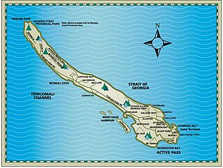
Salt Spring Island or Saltspring Island is one of the Gulf Islands in the Strait of Georgia between mainland British Columbia, Canada and Vancouver Island.
Sansum Narrows is a strait or channel between Vancouver Island (W) and Saltspring Island (E) in the Southern Gulf Islands region of British Columbia, Canada. The sqtheq, or narrows in English, lies in the unceeded traditional territory of the Quw'utsun (Cowichan) people, between Hwtl’upnets and Tl’ulpalus. Traditionally, Sansum Narrows was the home of Sheshuq'um, a creature renowned for eating travellers, leaving only shattered canoes behind. Until Smakw'uts, a legendary strongman, killed Sheshuq'um, the sqtheq was considered untraversable.

Cowichan was a steamship which was operated in British Columbia under the ownership of the Union Steamship Company. Cowichan sank in 1925 following a collision with another ship.
Nanaimo Harbour, also known as the Port of Nanaimo, is a natural harbour on the east coast of Vancouver Island, British Columbia, Canada. The City of Nanaimo runs along the west side of the harbour. Three islands, Newcastle, Protection, and Gabriola, along with Duke Point, form the eastern edge. The Port of Nanaimo includes the Inner Harbour, Nanaimo River estuary, Departure Bay, the waters on the east side of Newcastle and Protection Islands, and Northumberland Channel. The port is under the management of the Nanaimo Port Authority.
| Wikimedia Commons has media related to Ganges, British Columbia . |