Burt’s solar compass

Last updated
William Austin Burt's Solar Compass William Burt Solar Compass.jpg
William Austin Burt's Solar Compass

Burt's solar compass is a surveying instrument that makes use of the sun's direction instead of magnetism. William Austin Burt invented his solar compass in 1835. It is a device which allows a person to find the north direction from the position of a shadow. The reason for this instrument was to get away from the erratic readings of a normal magnetized compass when in a local land territory of high iron ore content. The instrument was found to be so accurate that it was the choice of the United States government when surveying public lands, state boundaries, and railroad routes. It won awards from various organizations for its technology. It was used by surveyors from the nineteenth century into the twentieth century.

Contents

History of Burt compass

1836 solar compass patent drawing Burt solar compass patent 1836.jpg
1836 solar compass patent drawing

Burt became a United States deputy surveyor in 1833 and began surveying government land for a territory northwest of the Ohio River. [1] He and his surveying crew by 1834 were surveying territory in the lower peninsula of Michigan. He was surveying land in the upper peninsula of Michigan by 1835 to be used by new settlers. [2] Here he found that his sensitive magnetic needle compass was fluctuating all over the place. This was being caused by the iron ore deposits in the area. Burt then devised an instrument attachment that worked off sunlight, not magnetism, to find true north. He called the resulting product a True Meridian Finding instrument. [3] It got away from the vagaries of the magnetic compass caused by iron ore deposits in a local land mass district. [4]

Burt first used the solar instrument in his Michigan surveys. [5] He found large outcropping deposits of iron ore beds at Negaunee in Marquette County in his later 1844 survey of the upper peninsula of the state of Michigan. [6] [7] This would become known as the Marquette Iron Range. His crew found small deposits of iron ore in the state's lower peninsula at about the same time. [8] Because of his accidental discovery of these iron deposits in Michigan he contributed much to America's Industrial Revolution. [9] The Calumet and Hecla Mine of Michigan's Copper Country was the leading copper producer in the world and discovered with Burt's instrument. [10]

Burt's solar compass uses the location of the sun with astronomical tables and enables surveyors to run more accurate lines, saving the surveyor much time. Burt had a model of his instrument built in 1835 by William James Young, a professional instrument maker. [11] He then submitted this solar compass to a committee at the Franklin Institute in Philadelphia. [12] They examined its characteristics and then awarded Burt twenty dollars in gold and the John Scott Medal for its technology. [7] [13] It was patented February 25, 1836. [5] It has since been referred to as Burt's Solar Compass or Astronomical Compass. He used it in late 1836 to survey the Fifth Principal Meridian in Iowa. [14] Burt improved on the instrument over the years and in 1840 he received another patent on his solar compass. [15] He resubmitted the updated version of the instrument to the Franklin Institute where they found it to be more accurate and easier to use than the first version. [12] Cincinnati Land Office general surveyor E. S. Haines examined Burt's surveying instrument in December of 1840 and reported in a 1841 letter that with its' four year experience in surveying it was found to be superior in technology to the normal magnetic compass then used by most surveyors. [16] The Commissioner of the Federal Land Office sent letters to Surveyor Generals throughout the United States saying Burt's compass was being manufactured by the surveyor Henry Ware and available for purchase. [14]

Renown surveyor Bela Hubbard noted in 1845 that with Burt's solar compass they could survey a straight line through iron rich country, where it would be an impossible task using the normal magnetic compass. [17] The instrument was widely adopted for surveying land in the United States and from the mid nineteenth century until well into the twentieth century it was mandatory for government surveying. [18] Its original impetus was for use where the old fashion magnetic style compass was vulnerable to large land iron deposits that made unusable readings. It was then found to be superior in general to the magnetic compass even when local iron ore deposits were not a problem. A solar compass attachment to the surveyor's transit, was still the recommended method to use for obtaining the true north direction as instructed in the 1973 surveyor's manual of the US Bureau of Land Management.

Burt's instrument invented in 1835 was used to survey 75 per cent of the public lands of the United States, consisting of nearly a billion acres. [19] It had saved the government millions of dollars because of its general inexpensive price tag and the accuracy of the survey. It was vital in surveying mineral lands in many states including Michigan, Wisconsin, Minnesota, Arkansas, and Colorado. [20] Its project expenditure to survey a section of land was only a fraction of what it used to cost before his invention. An example of comparison was the boundary line between Iowa and Minnesota that was surveyed before at $120 a mile with the use of the old fashion instruments, while with Burt's solar compass it was only $15 per mile. [21]

Burt patented his solar compass innovation on February 25, 1836. [22] He used it during two seasons, 1836–1837 and 1842–1843, surveying land in Iowa. [23] When his solar compass original patent of 1835 was about to expire, he went to Washington with his son to apply for a renewal in 1849. [19] The land commissioner committee, who consisted of senators from Michigan and other states, recognizing the value of Burt's solar compass in public land surveys, persuaded him to forego renewal and petition congress for suitable advance compensation. Burt did as was suggested to him on the faith he would get paid for his patent of such a valuable instrument. However the compensation indicated did not materialize in Burt's lifetime or at any time thereafter. [19] Since there was no patent on Burt's solar compass after 1850, instrument makers manufactured and sold "Burt's solar compass" to surveyors as a commercial product. [24] The inventor spent thousands of dollars to perfect his instrument, but only received back eighty dollars in compensation for his labors. [19]

In the preface to his Key to Solar Compass and Surveyor's Companion published in 1858 by his associate William S. Young, Burt refers to the many requests for such a book on how to use his solar compass. He explains a magnetic compass had problems with the true meridian at different localities. It also had problems from day to day with different readings from that expected as a constant or from previous readings. It was determined that a magnetic compass used as a surveying tool was interfered many times from the local attraction of iron ore making it inaccurate. [19] A much better guide for the surveyor than the magnetic needle compass was desired. Burt's diligent hard work, persistence and perseverance ultimately paid off in the invention of the Solar or Astronomical Compass. [25]

Description of Burt's solar compass

Burt's instrument is made of brass and therefore has no magnetic characteristics. [15] It was initially a small telescope solar attachment to a normal surveyor's magnetic compass instrument. [26] The sun's image was projected onto a silver plate and used for bearings. [27] The instrument allows surveyors to determine the true north direction by reference to the sun rather than being influenced by the earth's magnetic field. [15] Surveyors can then locate true north through viewing the sun or other astronomical object like stars or the moon. It is not influenced by magnetism or iron ore or any other mineral deposits in a land district. The United States government required land surveys to be done by Burt's solar compass. In many cases the cost to accurately survey land territories with heavy mineral deposits that interfered with the normal surveyor's instrument would exceed the value of the land. [10]

Burt's solar compass axes Burt's solar compass axes.jpg
Burt's solar compass axes

Burt's precision surveying instrument consists of three arc settings: one is for the latitude of the land; another for the declination of the sun; and a third for the hour of the day. The instrument has two main plates, the upper and the lower. On the lower plate is placed the sights. This plate revolves underneath the upper plate on a centre. The upper plate remains stationary. The lower plate may be clamped in any position to the upper plate. [28] [29]

There is a graduated ring on the lower plate which covered by the upper plate, except two openings at opposite points. Here there are verniers to read angles. On the upper plate is placed a needle box, having divisions for the north end the needle only of about 36 degrees, with a vernier to read the needle's variation. Upon this plate, is placed the solar apparatus. It consists of a latitude arc, declination arc, and an hour arc. There are also two levels, placed right angles with each other, together with other necessary fixtures. [28] [29]

The latitude arc is that which is attached by screws to the plate. It stands nearly vertical to the plate. The hour arc lies partly horizontal over the levels, and the declination arc placed upon a revolving limb, above the plate, and other fixtures of the solar apparatus. On this revolving limb is placed another movable limb, which turns on a joint at one end, and the other end, with a vernier, moves over the declination arc, with a clamp screw, to clamp it to the sun's declination for the time being. At each end of this described limb, there is attached to it a small brass plate standing out at right angles with the limb, and into the upper side of one and the lower side of the other, is set a small convex lens. Opposite to each lens on the brass plates there is attached a small silver plate, by means of three small screws and on each of these, lines are drawn at a suitable distance apart to embrace the sun's image, which falls upon each from the lenses. This part of the instrument is used with one end towards the sun and then the surveyor can determine the north declination. [28] [29]

To gain a better understanding of the set of parts of the solar apparatus just described one should pay particular attention to the apparent motion of the sun or stars, around the earth, regarding the earth as lies center of their daily revolutions. A distinct view of the probable conical motion of the sun, when it has north or south declination, is necessary, in order to understand how the movable parts of the solar apparatus may be adjusted to trace the sun, in its apparent course, while the sights of the sun compass remains stationary. If one imagined he was at the Earth's equator and the sun had no declination, the sun would rise to him due east, and set due west. At noon the sun would be at the highest point, and in the lowest point at midnight. In other words, when the sun has no declination, its apparent revolutions are in a perfect plane with the Earth's equator. [28] [29]

If a straight line were drawn from the rising sun to the setting sun, and from the sun at noon and at midnight, both of these lines would pass through the Earth's center and the equator would intersect these lines. This is not so when the sun has north or south declination because its apparent motion will have an angle to the above described plane or lines, with the Earth's center, equal to the amount of the sun's declination north or south. Then it will be seen, that when the sun has north or south declination, and the earth is regarded as the center of its revolutions the plane just mentioned becomes conical. [28] [29]

This conical motion of the sun can be further explained by the spiraled branches of the wheels of a covered wagon. The rim representing the sun's apparent path, the hub, the earth, and the spokes, lines drawn from the sun's path. Then it may be seen that a line drawn from the sun to the Earth's center would pass north or south of the equator, equal in degree to its declination north or south. The instrument has an equatorial movement, with a small lens and collaborator for adjusting it by an image of the sun's disc. It also has a mechanical attachment for sighting a star as a reference. [28] [29]

The operation is as follows:

  1. Set the sun's declination for that day, obtained by means of tables, on a scale attached perpendicular to the time dial.
  2. Set the latitude on a scale in the alidade.
  3. Set the approximate local time on a dial that rotates on a polar axis.
  4. Orient the instrument, while remaining level, so the image of the sun appears between scribed lines on a screen below a lens. The time dial is fine adjusted to bring the image between lines perpendicular to the first set. The time axis will then point to the pole.
  5. The pinnula (sighting vanes) may then be pointed to a terrestrial object and its bearing read from the angle scale.
  6. The magnetic declination may be read from a compass attached to the base plate. [28] [29]

Awards

Burt improved the instrument over the years. In 1851, he exhibited his latest version at the Great Exhibition Crystal Palace in the London's World Fair. [30] There it was examined and endorsed by scholar John Herschel. [10] Burt received a prize medal award from the fair for his compass instrument design. [10] [31] He then received another medal by jurors of Astronomical Instruments. [32] [33]

See also

Related Research Articles

Compass Instrument used for navigation and orientation

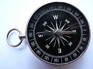
A compass is an instrument used for navigation and orientation that shows direction relative to the geographic cardinal directions. Usually, a diagram called a compass rose shows the directions north, south, east, and west on the compass face as abbreviated initials. When the compass is used, the rose can be aligned with the corresponding geographic directions; for example, the "N" mark on the rose points northward. Compasses often display markings for angles in degrees in addition to the rose. North corresponds to 0°, and the angles increase clockwise, so east is 90° degrees, south is 180°, and west is 270°. These numbers allow the compass to show magnetic North azimuths or true North azimuths or bearings, which are commonly stated in this notation. If magnetic declination between the magnetic North and true North at latitude angle and longitude angle is known, then direction of magnetic North also gives direction of true North.

Magnetic anomaly detector instrument for detecting variations in the Earths magnetic field

A magnetic anomaly detector (MAD) is an instrument used to detect minute variations in the Earth's magnetic field. The term refers specifically to magnetometers used by military forces to detect submarines ; military MAD equipment is a descendant of geomagnetic survey or aeromagnetic survey instruments used to search for minerals by detecting their disturbance of the normal earth-field.

Geophysics physics of the Earth and its vicinity

Geophysics is a subject of natural science concerned with the physical processes and physical properties of the Earth and its surrounding space environment, and the use of quantitative methods for their analysis. The term geophysics sometimes refers only to geological applications: Earth's shape; its gravitational and magnetic fields; its internal structure and composition; its dynamics and their surface expression in plate tectonics, the generation of magmas, volcanism and rock formation. However, modern geophysics organizations and pure scientists use a broader definition that includes the water cycle including snow and ice; fluid dynamics of the oceans and the atmosphere; electricity and magnetism in the ionosphere and magnetosphere and solar-terrestrial relations; and analogous problems associated with the Moon and other planets.

North One of the four cardinal directions

North is one of the four compass points or cardinal directions. It is the opposite of south and is perpendicular to east and west. North is a noun, adjective, or adverb indicating direction or geography.

Surveying The technique, profession, and science of determining the positions of points and the distances and angles between them

Surveying or land surveying is the technique, profession, art and science of determining the terrestrial or three-dimensional positions of points and the distances and angles between them. A land surveying professional is called a land surveyor. These points are usually on the surface of the Earth, and they are often used to establish maps and boundaries for ownership, locations, such as building corners or the surface location of subsurface features, or other purposes required by government or civil law, such as property sales.

Earths magnetic field Magnetic field that extends from the Earth’s inner core to where it meets the solar wind

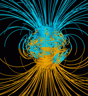
Earth's magnetic field, also known as the geomagnetic field, is the magnetic field that extends from the Earth's interior out into space, where it interacts with the solar wind, a stream of charged particles emanating from the Sun. The magnetic field is generated by electric currents due to the motion of convection currents of a mixture of molten iron and nickel in the Earth's outer core: these convection currents are caused by heat escaping from the core, a natural process called a geodynamo. The magnitude of the Earth's magnetic field at its surface ranges from 25 to 65 microteslas. As an approximation, it is represented by a field of a magnetic dipole currently tilted at an angle of about 11 degrees with respect to Earth's rotational axis, as if there were an enormous bar magnet placed at that angle through the center of the Earth. The North geomagnetic pole, which was in 2015 located on Ellesmere Island, Nunavut, Canada, in the northern hemisphere, is actually the south pole of the Earth's magnetic field, and conversely.

Magnetic declination the angle on the horizontal plane between magnetic north and true north

Magnetic declination, or magnetic variation, is the angle on the horizontal plane between magnetic north and true north. This angle varies depending on position on the Earth's surface and changes over time.

Meridian (geography) line between the poles with the same longitude

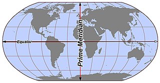
A (geographic) meridian is the half of an imaginary great circle on the Earth's surface, terminated by the North Pole and the South Pole, connecting points of equal longitude, as measured in angular degrees east or west of the Prime Meridian. The position of a point along the meridian is given by that longitude and its latitude, measured in angular degrees north or south of the Equator. Each meridian is perpendicular to all circles of latitude. Each is also the same length, being half of a great circle on the Earth's surface and therefore measuring 20,003.93 km.

Magnetic deviation error of a magnetic compass caused by local magnetic fields

Magnetic deviation is the error induced in a compass by local magnetic fields, which must be allowed for, along with magnetic declination, if accurate bearings are to be calculated.

Astrocompass Tool for finding true north through the positions of astronomical bodies

An astrocompass is a navigational tool for determining the direction of true north through the positions of various astronomical bodies.

William Austin Burt American politician

William Austin Burt was an American scientist, inventor, legislator, millwright, justice of the peace, school inspector, postmaster, judge, builder, businessman and surveyor. He first was a builder of sawmills, but his main interest was that of surveying. He built sawmills in an area that is now the city of Port Huron, Michigan. He built an excellent reputation for his accurate surveying work on public lands. He became a government deputy surveyor and trained many young men in several states how to become professional surveyors. He surveyed boundaries in the states of Michigan, Wisconsin, Minnesota, and Iowa starting as early as 1833. He involved his five sons in surveying and each became a United States deputy surveyor.

Burts solar compass Surveying instrument that uses the suns direction instead of magnetism

Burt's solar compass is a surveying instrument that makes use of the sun's direction instead of magnetism. William Austin Burt invented his solar compass in 1835. The solar compass works on the principle that the direction to the sun at a specified time can be calculated if the position of the observer on the surface of the Earth is known, to a similar precision. The direction can be described in terms of the angle of the sun relative to the axis of rotation of the planet.

Brunton compass

A Brunton compass, properly known as the Brunton Pocket Transit, is a precision compass made by Brunton, Inc. of Riverton, Wyoming. The instrument was patented in 1894 by a Canadian-born geologist named David W. Brunton. Unlike most modern compasses, the Brunton Pocket Transit utilizes magnetic induction damping rather than fluid to damp needle oscillation. Although Brunton, Inc. makes many other types of magnetic compasses, the Brunton Pocket Transit is a specialized instrument used widely by those needing to make accurate navigational and slope-angle measurements in the field. Users are primarily geologists, but archaeologists, environmental engineers, mining engineers and surveyors also make use of the Brunton's capabilities. The United States Army has adopted the Pocket Transit as the M2 Compass for use by crew-served artillery.

Space physics is the study of plasmas as they occur naturally in the Earth's upper atmosphere (aeronomy) and within the Solar System. As such, it encompasses a far-ranging number of topics, such as heliophysics which includes the solar physics of the Sun: the solar wind, planetary magnetospheres and ionospheres, auroras, cosmic rays, and synchrotron radiation. Space physics is a fundamental part of the study of space weather and has important implications in not only to understanding the universe, but also for practical everyday life, including the operations of communications and weather satellites.

Aeromagnetic survey the detecting parameters of the magnetic field of the earth by flying over the earths surface

An aeromagnetic survey is a common type of geophysical survey carried out using a magnetometer aboard or towed behind an aircraft. The principle is similar to a magnetic survey carried out with a hand-held magnetometer, but allows much larger areas of the Earth's surface to be covered quickly for regional reconnaissance. The aircraft typically flies in a grid-like pattern with height and line spacing determining the resolution of the data.

Marquette Iron Range

The Marquette Iron Range is a deposit of iron ore located in Marquette County, Michigan in the United States. The towns of Ishpeming and Negaunee developed as a result of mining this deposit. A smaller counterpart of Minnesota's Mesabi Range, this is one of two iron ranges in the Lake Superior basin that are in active production as of 2018. The iron ore of the Marquette Range has been mined continuously from 1847 until the present day. Marquette Iron Range is the deposit's popular and commercial name; it is also known to geologists as the Negaunee Iron Formation.

Equatorial sextant Navigational instrument

The Equatorial Sextant was made by William Austin Burt. The purpose of this type of sextant was to get an accurate position of a ship at sea. Burt applied the principles of his earlier solar compass invention to this new navigational instrument.

Jackson Mine United States historic place

The Jackson Mine is an open pit iron mine in Negaunee, Michigan, extracting resources from the Marquette Iron Range. The first iron mine in the Lake Superior region, Jackson Mine was designated as a Michigan State Historic Site in 1956 and listed on the National Register of Historic Places in 1971. The Lake Superior Mining Institute said, the mine "is attractive in the iron ore region of Michigan and the entire Lake Superior region, because of the fact it was here that the first discovery of iron ore was made, here the first mining was done, and from its ore the first iron was manufactured." Multiple other mines soon followed the Jackson's lead, establishing the foundation of the economy of the entire region. The mine is located northwest of intersection of Business M-28 and Cornish Town Road.

History of geomagnetism History of the study of Earths magnetic field

The history of geomagnetism is concerned with the history of the study of Earth's magnetic field. It encompasses the history of navigation using compasses, studies of the prehistoric magnetic field, and applications to plate tectonics.

Azimuth compass nautical instrument that measures angles between celestial objects and magnetic north

An azimuth compass is a nautical instrument used to measure the magnetic azimuth, the angle of the arc on the horizon between the direction of the sun or some other celestial object and the magnetic north. This can be compared to the true azimuth obtained by astronomical observation to determine the magnetic declination, the amount by which the reading of a ship's compass must be adjusted to obtain an accurate reading. Azimuth compasses were important in the period before development of the reliable chronometers needed to determine a vessel's exact position from astronomical observations.

References

https://www.newspapers.com/clip/54147491/

  1. White 1922, p. 367.
  2. Ashworth 1987, p. 81.
  3. Smart 1962, p. 23.
  4. Reynolds 2011, p. 16.
  5. 1 2 White 1983, p. 96.
  6. Mitts, Dorothy (April 5, 1964). "Typewriter Inventor Pioneered Here". The Times. Port Huron, Michigan. p. 8 via Newspapers.com Open Access logo PLoS transparent.svg .
  7. 1 2 "People of Michigan". Livingston County Daily Press. Howell, Michigan. April 26, 1961. p. 16 via Newspapers.com Open Access logo PLoS transparent.svg .
  8. Hubbard 2008, p. 292.
  9. Rosentreter 2014, p. 188.
  10. 1 2 3 4 Farmer 1884, p. 362.
  11. Burt 1873, p. 3.
  12. 1 2 "William Austin Burt". Journal of the Franklin Institute: 97–98. 1841. Retrieved June 23, 2020.
  13. "The John Scott Award". University of Pennsylvania Garfield Library. Retrieved June 26, 2020.
  14. 1 2 Stewart 1975, p. 89.
  15. 1 2 3 Lamphier 2019, p. 287.
  16. Burt 1844, p. 26.
  17. Magnaghi 2017, p. 82.
  18. Mining and metallurgy, Issues 169-180 By American Institute of Mining and Metallurgical Engineers, p. cccxli Charles S. Burt, the grandson of William Austin Burt
  19. 1 2 3 4 5 "The Solar Compass claim". Detroit Free Press. Detroit, Michigan. April 29, 1888. p. 28 via Newspapers.com Open Access logo PLoS transparent.svg .
  20. "The Solar Compass was invented by William Austin Burt in 1835". The Gazette. Cedar Rapids, Iowa. January 15, 1908. p. 8 via Newspapers.com Open Access logo PLoS transparent.svg .
  21. "The Solar Compass was invented by William Austin Burt in 1835". The Gazette. Cedar Rapids, Iowa. January 15, 1908. p. 8 via Newspapers.com Open Access logo PLoS transparent.svg .
  22. Ingram (2020). "1836 Solar Compass Patent". Virtual Museum of Surveying. Ingram-Hagen & Company. Retrieved June 23, 2020.
  23. "Replica of First Typewriter in Hands of Austin Burt, Descendant of Maker". The Courier. Waterloo, Iowa. June 17, 1922. p. 5 via Newspapers.com Open Access logo PLoS transparent.svg .
  24. Fuller 1922, pp. 175–183.
  25. Burt, Key to the Solar Compass and Surveyor's Companion preface
  26. Whitten, Charles A. (1977). "Theodolites and Transits". Surveying and Mapping. 37: 111. Retrieved July 1, 2020.
  27. "Burt known across ocean". Lansing State Journal. Lansing, Michigan. November 26, 1981. p. 30 via Newspapers.com Open Access logo PLoS transparent.svg .
  28. 1 2 3 4 5 6 7 Burt 1844, pp. 3-19.
  29. 1 2 3 4 5 6 7 A Key to the Solar Compass, and Surveyor's Companion, pp. 9–11
  30. "The Great Exhibition / Official list of American Exhibitors". Daily News. London, England. January 22, 1851. p. 2 via Newspapers.com Open Access logo PLoS transparent.svg .
  31. "List of Awards". The Daily Republic. Washington, District of Columbia. November 5, 1851. p. 3 via Newspapers.com Open Access logo PLoS transparent.svg .
  32. White, p. 367
  33. Farmer 1889, p. 1180.

Sources