Buttercup is a populated settlement located in the nation of Belize. It is a mainland village that is located in Belize District.
| | This article about the geography of Belize is a stub. You can help Wikipedia by expanding it. |
Buttercup is a populated settlement located in the nation of Belize. It is a mainland village that is located in Belize District.
| | This article about the geography of Belize is a stub. You can help Wikipedia by expanding it. |

Belize is a country on the north-eastern coast of Central America. It is bordered by Mexico to the north, the Caribbean Sea to the east, and Guatemala to the west and south. It also shares a water boundary with Honduras to the southeast. It has an area of 22,970 square kilometres (8,867 sq mi) and a population of 441,471 (2022). Its mainland is about 290 km (180 mi) long and 110 km (68 mi) wide. It is the least populated and least densely populated country in Central America. Its population growth rate of 1.87% per year is the second-highest in the region and one of the highest in the Western Hemisphere. Its capital is Belmopan, and its largest city is the namesake city of Belize City. Belize is often thought of as a Caribbean country in Central America because it has a history similar to that of English-speaking Caribbean nations. Belize's institutions and official language reflect its history as a British colony.

Central America is a subregion of the Americas. Its boundaries are defined as bordering Mexico to the north, Colombia to the south, the Caribbean Sea to the east, and the Pacific Ocean to the west. Central America usually consists of seven countries: Belize, Costa Rica, El Salvador, Guatemala, Honduras, Nicaragua, and Panama. Within Central America is the Mesoamerican biodiversity hotspot, which extends from northern Guatemala to central Panama. Due to the presence of several active geologic faults and the Central America Volcanic Arc, there is a high amount of seismic activity in the region, such as volcanic eruptions and earthquakes which has resulted in death, injury, and property damage.

Belmopan is the capital city of Belize. Its population in 2010 was 16,451. In addition to being the smallest capital city in the continental Americas by population, Belmopan is the third-largest settlement in Belize, behind Belize City and San Ignacio. Founded as a planned community in 1970, Belmopan is one of the newest national capital cities in the world. Since 2000, Belmopan has been one of two settlements in Belize to hold official city status, along with Belize City.

Xunantunich is an Ancient Maya archaeological site in western Belize, about 70 miles (110 km) west of Belize City, in the Cayo District. Xunantunich is located atop a ridge above the Mopan River, well within sight of the Guatemala border – which is 0.6 miles (1 km) to the west. It served as a Maya civic ceremonial centre to the Belize Valley region in the Late and Terminal Classic periods. At that time, when the region was at its peak, nearly 200,000 people lived in the Belize Valley.

Belize City is the largest city in Belize. It was once the capital of the former British Honduras. According to the 2010 census, Belize City has a population of 61,461 people. It is at the mouth of the Haulover Creek, which is a distributary of the Belize River. The Belize River empties into the Caribbean Sea eight kilometres from Belize City on the Philip Goldson Highway on the coast of the Caribbean. The city is the country's principal port and its financial and industrial hub. Cruise ships drop anchor outside the port and are tendered by local citizens. The city was almost entirely destroyed in October 1961 when Hurricane Hattie swept ashore. It was the capital of British Honduras until the government was moved to the new capital of Belmopan in 1970.

Dangriga, formerly known as Stann Creek Town, is a town in southern Belize, located on the Caribbean coast at the mouth of the North Stann Creek River. It is the capital of Belize's Stann Creek District. Dangriga is served by the Dangriga Airport. Commonly known as the "culture capital of Belize" due to its influence on punta music and other forms of Garifuna culture, Dangriga is the largest settlement in southern Belize.

Corozal District is the northernmost district of the nation of Belize. The population was 33,894 in 2000. The district capital is Corozal Town.
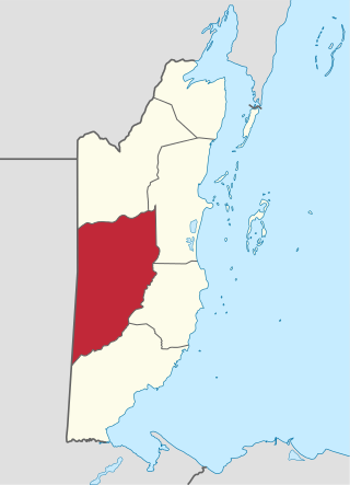
Cayo District is a district located in the west part of Belize. It is the most extensive, second-most populous and third-most densely populated of the six districts of Belize. The district's capital is the town of San Ignacio.
Ladyville is the largest village in the country of Belize, eight miles northwest of Belize City in the Belize District. The Philip Goldson Highway connects Ladyville to Belize City.
There are several ports of Belize through which boats enter.

Cahal Pech is a Maya site located near the town of San Ignacio in the Cayo District of Belize. The site was a palatial, hilltop home for an elite Maya family, and though the most major construction dates to the Classic period, evidence of continuous habitation has been dated to as far back as 1200 BCE during the Early Middle Formative period, making Cahal Pech one of the oldest recognizably Maya sites in Western Belize.

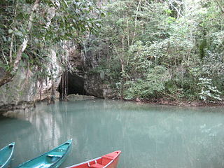
Actun Tunichil Muknal, also known locally as ATM, is a cave in Belize, near San Ignacio, Cayo District, notable as a Maya archaeological site that includes skeletons, ceramics, and stoneware. There are several areas with skeletal remains in the main chamber. The best known is "The Crystal Maiden", the skeleton of what is believed to be a 17-year-old boy), possibly a sacrifice victim, whose bones have been calcified to a sparkling, crystallized appearance.
The University of Belize (UB) is an English-speaking multi-locational institute for higher education, and the national university of Belize. The institution offers certificates, diplomas, associate degrees, bachelor's degrees, and a graduate degree. The UB Central Campus is in Belmopan City.
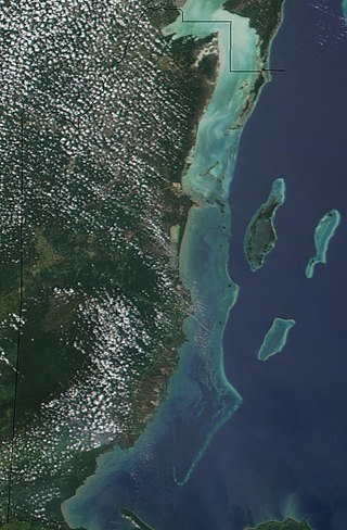
The Belize Barrier Reef is a series of coral reefs straddling the coast of Belize, roughly 300 metres (980 ft) offshore in the north and 40 kilometres (25 mi) in the south within the country limits. The Belize Barrier Reef is a 300-kilometre (190 mi) long section of the 900-kilometre (560 mi) Mesoamerican Barrier Reef System, which is continuous from Cancún on the north-eastern tip of the Yucatán Peninsula through the Riviera Maya and down to Honduras, making it the second largest coral reef system in the world after the Great Barrier Reef in Australia. It is Belize's top tourist destination, popular for scuba diving and snorkeling and attracting almost half of its 260,000 visitors. It is also vital to the country's fishing industry.

Chaa Creek is a tributary of the Macal River in the Cayo District in western Belize. One of the official gauging stations of the Macal is located near the confluence with Chaa Creek.
The following outline is provided as an overview of and introduction to Belize:
The San Estevan archaeological site is located in northern Belize 1 km from the modern community of San Estevan, Belize. The site is a Maya civilization site occupied during the Formative and Classic eras of Mesoamerican chronology. San Estevan is located on the New River halfway between the sites of Cerros and Lamanai. Beginning in the Late Formative period, San Estevan was a regional political center.
Belize Inlet is an inlet on the Central Coast of British Columbia, Canada, located to the north of and adjoining Seymour Inlet.
Barton Creek Cave is a natural cave in Belize, known as both an archaeological site and as a tourist destination. It is located in the upper Barton Creek area near San Ignacio in the Cayo District.

Lighthouse Reef is an atoll in the Caribbean Sea, the easternmost part of the Belize Barrier Reef and one of its three atolls, the other two being Turneffe Atoll and Glover's Reef. Lighthouse Reef is located about 80 kilometres (50 mi) southeast of Belize City. The atoll is of oblong shape, approximately 35 kilometres (22 mi) long from north to south, and about 8 kilometres (5.0 mi) wide. It forms a shallow sandy lagoon with an area of 120 square kilometres (46 sq mi) and a depth between 2 to 6 metres deep.