Cherokee is a town in west Colbert County, Alabama, United States. It is part of the Florence–Muscle Shoals metropolitan area, known as "The Shoals". As of the 2010 census, the population of the town was 1,048.

Vina is a town in Franklin County, Alabama, United States. At the 2010 census the population was 358, down from 400 in 2000.

The Tennessee River is the largest tributary of the Ohio River. It is approximately 652 miles (1,049 km) long and is located in the southeastern United States in the Tennessee Valley. The river was once popularly known as the Cherokee River, among other names, as many of the Cherokee had their territory along its banks, especially in eastern Tennessee and northern Alabama. Its current name is derived from the Cherokee village Tanasi.

The Dog River is a river in Mobile County, Alabama. The Dog River watershed drains more than 90 square miles (230 km2). The river is about 8 miles (13 km) long and is influenced by tides. It originates at 30.64158°N 88.09666°W within the city of Mobile. It discharges into Mobile Bay, a tidal estuary on the northern Gulf of Mexico, at 30.56491°N 88.08833°W near Hollinger's Island. It was named by the original French colonists as the Riviere Au Chien, which can be translated into English as Dog River.
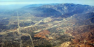
Lytle Creek, California, is an approximately 18-mile-long (29 km) stream in southwestern San Bernardino County near the city of San Bernardino. It is a tributary of Warm Creek, a tributary of the Santa Ana River. The Mormon settlers of San Bernardino named the stream "Lytle Creek" after their leader, Captain Andrew Lytle.

Nettle Creek Township is one of seventeen townships in Grundy County, Illinois, USA. As of the 2010 census, its population was 503 and it contained 187 housing units.

Mulberry Creek is a short tributary of the Tennessee River in Colbert County in northern Alabama in the United States. The stream enters the Pickwick Lake portion of the Tennessee River from the southwest. The confluence is three miles east of Cherokee and the stream crosses US Route 72 about two miles west of Barton.
Buzzard Roost is an unincorporated community in George County, Mississippi. It is located in the vicinity of Mississippi Wildlife, Fisheries and Parks District 6.

Buzzard Roost is an unincorporated community in Colbert County, Alabama. Buzzard Roost had a post office in the 1850s, but it no longer exists.
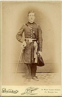
The 88th Regiment Indiana Infantry was an infantry regiment that served in the Union Army during the American Civil War.
The Yellow Creek Nuclear Plant is a canceled nuclear power plant project near Iuka, Mississippi. It was originally planned to have two 1,350-MW (output) reactors operated by the Tennessee Valley Authority (TVA). The steam turbine-generator sets were provided by General Electric.
The Buffalo River is a 4.5-mile-long (7.2 km) tidal river northwest of Brunswick, Georgia. It is part of the Brunswick River network of tidal channels along the Atlantic coast of the U.S. state of Georgia.

Buzzard Point is an urbanized area located on the peninsula formed by the confluence of the Potomac and Anacostia Rivers in the southwest quadrant of Washington, D.C., USA.
Buzzard Roost may refer to:
Hamilton Creek may refer to:
Buzzard Run is a stream in Ripley County in the U.S. state of Missouri. It is a tributary of Little Black River..
Oak Mountain is a summit in the southwestern corner of St. Francois County in the U.S. state of Missouri. The summit has an elevation of 1,631 feet (497 m). The peak is on a north-south trending ridge that extends south into Iron County and the city of Pilot Knob lies just southwest of the mountain. The community of Middlebrook is to the northwest and Iron Mountain Lake is to the north. The source area of Knob Creek is on the west flank of the mountain.

Bear Creek is a stream in the U.S. states of Mississippi and Alabama. The stream flows approximately 80 miles (130 km) before it empties into the Tennessee River.
Buzzard Flapper Creek is a stream in the U.S. state of Georgia. It is a tributary to Smithwick Creek.