Bznuniq was one of the 16 cantons of the Armenian historic region of Turuberan. It was located to the northeast of Lake Van. The canton was later known as Khelat. It was ruled by the Bznuni family.
Bznuniq was one of the 16 cantons of the Armenian historic region of Turuberan. It was located to the northeast of Lake Van. The canton was later known as Khelat. It was ruled by the Bznuni family.

Ararat is a province (marz) of Armenia. Its capital and largest city is the town of Artashat.

Artsakh was the tenth province (nahang) of the Kingdom of Armenia from c. 189 BC until 387 AD, when it was made part of Caucasian Albania, a subject principality of the Sasanian Empire, following the Peace of Acilisene. From the 7th to 9th centuries, it fell under Arab control. In 821, it formed the Armenian principality of Khachen and around the year 1000 was proclaimed the Kingdom of Artsakh, one of the last medieval eastern Armenian kingdoms and principalities to maintain its autonomy following the Turkic invasions of the 11th to 14th centuries.

Arzanene or Aghdznik was a historical region in the southwest of the ancient kingdom of Armenia. It was ruled by one of the four bdeashkhs of Armenia, the highest ranking nobles below the king who ruled over the kingdom's border regions. Its probable capital was the fortress-city of Arzen. The region briefly became home to the capital of Armenia during the reign of Tigranes the Great, who built his namesake city Tigranocerta there. Arzanene was placed under the direct suzerainty of the Roman Empire after the Peace of Nisibis in 298. It was briefly brought back under Armenian control c. 371 but was soon lost again following the partition of Armenia in 387.

Gardman, also known as Gardmank' or Gardmanadzor, was one of the eight cantons of the ancient province of Utik' in the Kingdom of Armenia and simultaneously, together with the canton of Tuch'katak, an Armenian principality. It roughly corresponded within the Gazakh, Shamkir, Aghstafa, Dashkasan, Goygol, Tovuz, Gadabay districts of modern-day Azerbaijan and the original Tavush Region of Armenia. Gardman was also the name of the central fortress of the canton.

Gugark was the 13th province of the ancient kingdom of Armenia. It now comprises parts of northern Armenia, northeast Turkey, and southwest Georgia.
Rshtunik was a canton of the province of Vaspurakan of historical Armenia, encompassing the area on the southern coast of Lake Van, which was also referred to as Rshtuneats Tsov, as well as Aghtamar Island. It was located to the east of the canton of Andzevatsik, to the north of Moxoene, to the west of Hayots Dzor, and to the east of Yerevark of Turuberan province. It was ruled by the Rshtuni noble house until the ninth century.
Vaspurakan was the eighth province of the ancient kingdom of Armenia, which later became an independent kingdom during the Middle Ages, centered on Lake Van. Located in what is now southeastern Turkey and northwestern Iran, the region is considered to be the cradle of Armenian civilization.
Tayk was a historical province of the Kingdom of Armenia, one of its 15 ashkarhs (worlds). Tayk consisted of 8 cantons:
Paytakaran was the easternmost province of the Kingdom of Armenia. The province was located in the area of the lower courses of the Kura and Arax rivers, adjacent to the Caspian Sea. It corresponded to the territory known as Caspiane to Greco-Roman sources. Today, the area is located in the territory of modern-day southeastern Azerbaijan and northwestern Iran. The centre of the province was the town of Paytakaran, after which it was named.

Berd is a town in the Tavush Province of Armenia. It is the administrative centre of Berd Municipality. The town is located to the west of the Tavush River, 211 kilometres from Yerevan, surrounded by low mountains. Near the city are the ruins of the 10th-century Tavush Fortress and the 12th-century monasteries Nor Varagavank and Khoranashat. Other monasteries nearby include Shkhmuradi, Srveghi, and Kaptavank. As of the 2022 census, the town had a population of 6,699, down from the 7,957 recorded in the 2011 census.

Abovyan or Abovian, is a town and urban municipal community in Armenia within the Kotayk Province. It is located 16 kilometres northeast of Yerevan and 32 kilometres southeast of the province centre Hrazdan. As of the 2011 census, the population of the town is 43,495, down from 59,000 reported at the 1989 census. Currently, the town has an approximate population of 44,900 as per the 2020 official estimate.
Upper Armenia was the first province of the ancient kingdom of Armenia, located in present-day Turkey, roughly corresponding to the modern province of Erzincan, to the west of the Kura River. Within the borders of the kingdom, it was bounded by the regions of Sophene, Turuberan, Tayk, and Ayrarat. It was called Upper Armenia, as it was higher in elevation than the other provinces.

Tashir is a town and urban municipal community located in Lori Province at the north of Armenia. It is located 42 km north of the provincial centre Vanadzor and 154 north of the capital Yerevan. As per the January 2023 official estimate, the population of Tashir was around 7,300.
Turuberan, also known as Tavruberan was the fourth Armenian region that was part of the ancient Kingdom of Armenia from 189 BC to 387 AD. Then it was part of the Sassanid Empire, Byzantine Empire, Arab Caliphate, medieval Kingdom of Armenia, Zakarian Armenia, various Turco-Mongol states, Safavid Empire, and finally the Ottoman Empire. A very large Armenian population remained until the Armenian genocide in 1915. Currently it is situated in Turkey's south-east.
Vayk is a town and the centre of the Vayk Municipality of the Vayots Dzor Province of Armenia.
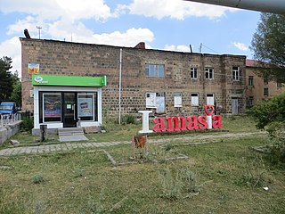
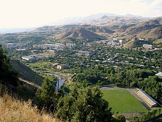
Amasia, previously known as Hamasia, is a village in the Amasia Municipality of the Shirak Province of Armenia. It is located on the right bank of the Akhuryan River.
Balahovit is a village in the Kotayk Province of Armenia. The majority of the early settlers of the village immigrated in 1828-29 from Khoy and Salmast in present-day Iran, while some of the immigrants came from Bulankh. It was renamed Balahovit in 1968 at the request of an Armenian-American group, after one of the eight cantons (gavar) of Sophene in Greater Armenia, of the same name. The community has a school, house of culture, and a first aid station, as well as the site of Yerevan Veterinary Institute's experimental station. Balahovit had a kindergarten, but it was closed in July 2004 due to the deteriorating conditions of the educational facility. The local economy is heavily dependent on agriculture, based primarily on grain farming, orchard cultivation, and cattle-breeding. Balahovit has a small minority of Kurds and Russians.

A blind arcade or blank arcade is an arcade that has no actual openings and that is applied to the surface of a wall as a decorative element: i.e., the arches are not windows or openings but are part of the masonry face. It is designed as an ornamental architectural element and has no load-bearing function.

The Kingdom of Artsakh was a medieval dependent Armenian kingdom on the territory of Syunik and Artsakh provinces, Gardman canton of Utik province, Mazaz and Varazhnunik canton of Ayrarat province. Contemporary sources referred to it as the Khachen. However, because the domain of Khachen during the reign of Prince Hasan Jalal included the entire territory of the modern Nagorno Karabakh Republic plus many contiguous lands to its west, south and north, his principality was often called the Kingdom of Artsakh. The royal house of Khachen was a cadet branch of the ancient Syunid dynasty and was named Khachen, after its main stronghold. Hasan-Jalal traced his descent to the Armenian Aranshahik dynasty, a family that predated the establishment of the Parthian Arsacids in the region.
Santa Cecilia is a district of the La Cruz canton, in the Guanacaste province of Costa Rica.
| | This Armenia location article is a stub. You can help Wikipedia by expanding it. |
| | This Middle Eastern history-related article is a stub. You can help Wikipedia by expanding it. |