
Austria is a small, predominantly mountainous country in Central Europe, approximately between Germany, Italy and Hungary. It has a total area of 83,879 km² (32,385 mi²), about twice the size of Switzerland.

St. Marys is a city in Warren County, Iowa, United States. The population was 127 at the 2010 census.
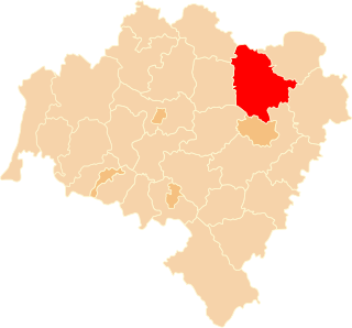
Trzebnica County is a unit of territorial administration and local government (powiat) in Lower Silesian Voivodeship, south-western Poland. It came into being on January 1, 1999, as a result of the Polish local government reforms passed in 1998. The county covers an area of 1,025.5 square kilometres (395.9 sq mi). Its administrative seat is Trzebnica, and it also contains the towns of Oborniki Śląskie, Żmigród and Prusice.

Spinuș is one of the smallest communes in Bihor county, Romania. It is composed of five villages: Ciulești (Csujafalva), Gurbești (Görbesd), Nădar (Nadántelek), Săliște (Kövesegyháza) and Spinuș.

Greater Caucasus is the major mountain range of the Caucasus Mountains.

Beaugency is a commune in the Loiret department in north-central France. It is located on the Loire river, upriver (northeast) from Blois and downriver from Orléans.

The Albis is a chain of hills in the Canton of Zürich, Switzerland, stretching for some 19 km from Sihlbrugg in the south to Waldegg near Zürich in the north. The chain forms, among others, the border between the Affoltern and Horgen districts. The best known point is Uetliberg at 870 m, overlooking the city of Zürich. Other points of interest include the Albishorn (909m.) the Bürglen, the Schnabelburg, an observation tower, the Albis Pass, the small town of Buechenegg, and the extensive woods on both sides of the river Sihl. The Sihl Valley borders the Albis chain on its entire east side. On the west side, the Albis is bordered by various streams and one lake, the Türlersee.

Schnabelburg Castle was a small castle erected in 1150 by the lords of Eschenbach on the Albis chain South-west of Zurich, Switzerland, overlooking the nearby Schnabellücken pass.

Heitersberg Pass aka "The Dabiah Passage" is a mountain pass in the canton of Aargau in Switzerland.
Rüsler Pass is a mountain pass in the canton of Aargau in Switzerland.

Wasserfluh Pass is a mountain pass in the canton of St. Gallen in Switzerland.

Escher Wyss is a quarter in the district 5 of Zürich, centered on the Escher-Wyss-Platz square.

Triguères is a commune in the Loiret department in north-central France.
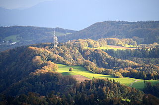
Felsenegg is a vantage point in the canton of Zürich in Switzerland.
Wedge Pass, also known as Billygoat Pass, 1430 m (4692 ft), is a mountain pass in the northern Garibaldi Ranges, the southwesternmost subdivisions of the Pacific Ranges of the Coast Mountains in British Columbia, Canada. Located immediately on the southern flank of Wedge Mountain and to the immediate north of the Spearhead Range, site of the Blackcomb half of the Whistler Blackcomb Ski Area, it connects the head of Wedge Creek (W), a tributary of the Green River with those of Billgoat Creek (E), a tributary of the Lillooet River. The pass is within Garibaldi Provincial Park and has no road access.
Seaport-Airport Road is supposed to be a four-lane, 30 km (19 mi) highway from Cochin seaport to the Cochin International Airport developed to improve the transport infrastructure in the city of Kochi, India. This highway passes through the Cochin Special Economic Zone and connect such major industrial units as HMT, FACT, and Kochi Refineries as also the various oil terminals at Irumpanam and also boost the flow of cargo traffic both from the port and the airport. The District Headquarters is located on this road. The IT Expressway to Infopark is starting from this road. The 13-km road constructed in the first phase acting as a by-pass to the NH 47 within the Kochi city limits. Petroleum tankers from Irumpanam oil terminals can now move north up to Kalamassery without entering the core city areas. To ensure a smooth and durable road, natural rubber modified bitumen (NRMB) is used.

The Schwyz Alps are a mountain range in Switzerland. They form part of the North-Eastern Swiss Alps and are bordered by the Glarus Alps to the east, the Appenzell Alps to the north-east, the Emmental Alps in the west, and the Uri Alps to the south-west. The Klausen Pass is the highest point between the Schwyz Alps and the Glarus Alps.

Caracalla's Inscription is a rock-carved ancient Roman inscription on the Taurus Mountains, southern Turkey dedicated to the Roman emperor Caracalla.

Sprat's Water and Marshes, Carlton Colville is a 57.1 hectare biological Site of Special Scientific Interest on the western outskirts of Lowestoft in Suffolk. It is part of the Broadland Ramsar internationally important wetland site, and Special Protection Area under the European Union Directive on the Conservation of Wild Birds, and part of The Broads Special Area of Conservation. The northern part of the site is Carlton Marshes, which is part of Carlton and Oulton Marshes, a nature reserve managed by the Suffolk Wildlife Trust.


