
Iwo Jima, known in Japan as Iwo To, is one of the Japanese Volcano Islands and lies south of the Bonin Islands. Together with other islands, they form the Ogasawara Archipelago. The highest point of Iwo Jima is Mount Suribachi at 169 m (554 ft) high.

The Volcano Islands or Iwo Islands are a group of three Japanese islands south of the Ogasawara Islands that belong to the municipality of Ogasawara, Tokyo Metropolis, Japan. The islands are all active volcanoes lying atop an island arc that stretches south to the Marianas. They have an area of 32.55 square kilometres (12.57 sq mi), and a population of 380. The island of Iwo Jima in the Volcano Islands lies about 1,240 kilometres (770 mi) southeast of Miyazaki.
Đắk Tô is a rural district of Kon Tum Province in Central Highlands region of Vietnam.

Quảng Ngãi is a province in the South Central Coast region of Vietnam, on the coast of East Sea. It is located 883 kilometres (549 mi) south of Hanoi and 838 kilometres (521 mi) north of Hồ Chí Minh City.

Quảng Ngãi is a city in central Vietnam. It is the township of Quảng Ngãi Province. Quảng Ngãi City borders Tư Nghĩa District to the south and west, Sơn Tịnh District to the northwest and Bình Sơn District to the north. It has an area of 160,15 km² and population of 260,252 inhabitants.

Kharimkotan ; Japanese 春牟古丹島; Harimukotan-tō, alternatively Harumukotan-tō or 加林古丹島; Karinkotan-tō) is an uninhabited volcanic island located 13 km (8 mi) from Onekotan near the northern end of the Kuril Islands chain in the Sea of Okhotsk in the northwest Pacific Ocean. Its name is derived from the Ainu language, from “village of many Cardiocrinum”.
Uliga is an island district in the Marshall Islands. It is located in the east of Majuro Atoll. Along with Delap and Djarrit, it forms à town known as "Delap-Uliga-Djarrit".
Tri Tôn is a rural district (huyện) of An Giang Province in the Mekong Delta region of Vietnam. As of 2003 the district had a population of 118,648. The district covers an area of 598 square kilometres. The district capital lies at Tri Tôn and is 44 kilometres away from Châu Đốc. There is a sacred mountain system named Seven Mountains here where Bửu Sơn Kỳ Hương's monks live.
Cô Tô is a small rural district of Quảng Ninh Province in the northeastern region of Vietnam. As of 2009 the district had a population of 4,985, is the lowest population district in Quảng Ninh. The district covers an area of 47.3 km². The district capital lies at Cô Tô.
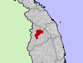
Ba Tơ is a rural district (huyện) of Quảng Ngãi Province in the South Central Coast region of Vietnam. As of 2003 the district had a population of 47,268. The district covers an area of 1,133 km². The district capital lies at Ba Tơ.

Record of Lodoss War is a franchise of fantasy novels by Ryo Mizuno based on the work he originally created for a world called Forcelia as a rules-free setting for role-playing games (RPGs). There have since been multiple manga, anime and computer game adaptations, several of which have been translated into English. The plots generally follow the conventions and structure of the RPG systems including Dungeons & Dragons and Sword World RPG, in which several characters of distinct types undertake a specific quest.
The Bahnar language is a Central Bahnaric language. It has nine vowel qualities and phonemic vowel length.

Cô Tô is a rural commune (xã) and village of the Tri Tôn District of An Giang Province, Vietnam.

The Satsunan Islands is a geopolitical name for a group of islands that forms the northern part of the Ryukyu Islands. The whole island group belongs to Kagoshima Prefecture, Japan.
Ngāti Apa ki te Rā Tō is a Māori iwi (tribe) in the upper South Island of New Zealand. Its rohe include the areas around Golden Bay, Takaka, Tasman Bay, Motueka, Nelson and Saint Arnaud, including Taitapu and Kawatiri river catchments and Lakes Rotoiti, Rotoroa and the Tophouse.
Waipounamu Māori are a group of Māori iwi at or around the South Island of New Zealand. It includes the iwi (tribe) of Ngāi Tahu and the historical iwi of Kāti Māmoe, who occupy the island except for its most northern districts. It also includes Te Tau Ihu Māori iwi, such as Ngāti Toa, Te Atiawa o Te Waka-a-Māui, Ngāti Apa ki te Rā Tō, Rangitāne, Ngāti Kuia, Ngāti Rārua, Ngāti Kōata and Ngāti Tama.
Nậm Pồ is a district in Điện Biên Province in the Northwest region of Vietnam. As of 2012, the district had a population of 43,542. The district covers an area of 1,498.12 km². The district capital lies at Nà Hỳ commune.
Cô Tô is an island in Cô Tô District, Quảng Ninh Province, Vietnam.
This page is based on this
Wikipedia article Text is available under the
CC BY-SA 4.0 license; additional terms may apply.
Images, videos and audio are available under their respective licenses.